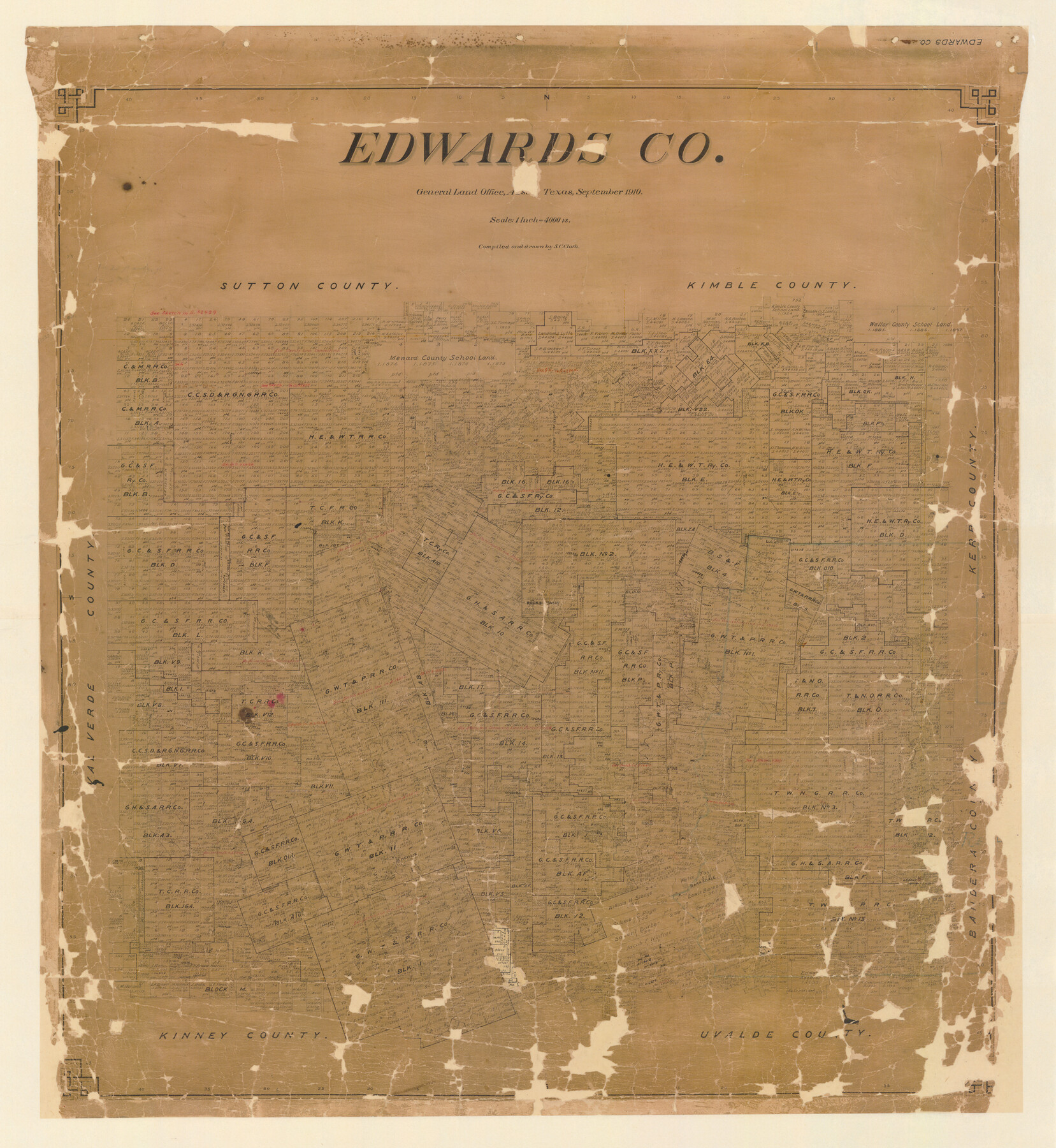
Edwards Co.
-
Map/Doc
16825
-
Collection
General Map Collection
-
Object Dates
1910 (Creation Date)
-
People and Organizations
Texas General Land Office (Publisher)
S.C. Clark (Compiler)
S.C. Clark (Draftsman)
-
Counties
Edwards
-
Subjects
County
-
Height x Width
38.8 x 35.7 inches
98.6 x 90.7 cm
-
Comments
Conservation funded in 2008 by Friends of the Texas General Land Office.
-
Features
South Llano River
Lula
Rock Springs
Brushy Creek
Colemans Ranch
Henzie
Kickapoo Springs
Leakey
Barksdale
Part of: General Map Collection
Hunt County Rolled Sketch 5

Print $20.00
- Digital $50.00
Hunt County Rolled Sketch 5
1956
Size 28.6 x 24.3 inches
Map/Doc 6268

Sterling County Sketch File 17

Print $8.00
- Digital $50.00
Sterling County Sketch File 17
1936
Size 11.2 x 8.8 inches
Map/Doc 37154
Stonewall County Working Sketch 34

Print $20.00
- Digital $50.00
Stonewall County Working Sketch 34
1985
Size 34.0 x 33.9 inches
Map/Doc 62341
Coke County Working Sketch 29

Print $20.00
- Digital $50.00
Coke County Working Sketch 29
1982
Size 19.6 x 25.4 inches
Map/Doc 68066
McMullen County

Print $20.00
- Digital $50.00
McMullen County
1967
Size 40.7 x 27.8 inches
Map/Doc 77363
Smith County Working Sketch 5

Print $20.00
- Digital $50.00
Smith County Working Sketch 5
1932
Size 32.2 x 22.4 inches
Map/Doc 63890
Wharton County Working Sketch 4

Print $20.00
- Digital $50.00
Wharton County Working Sketch 4
Size 16.3 x 21.3 inches
Map/Doc 72468
Navigation Maps of Gulf Intracoastal Waterway, Port Arthur to Brownsville, Texas

Print $20.00
- Digital $50.00
Navigation Maps of Gulf Intracoastal Waterway, Port Arthur to Brownsville, Texas
1951
Size 16.7 x 21.4 inches
Map/Doc 65417
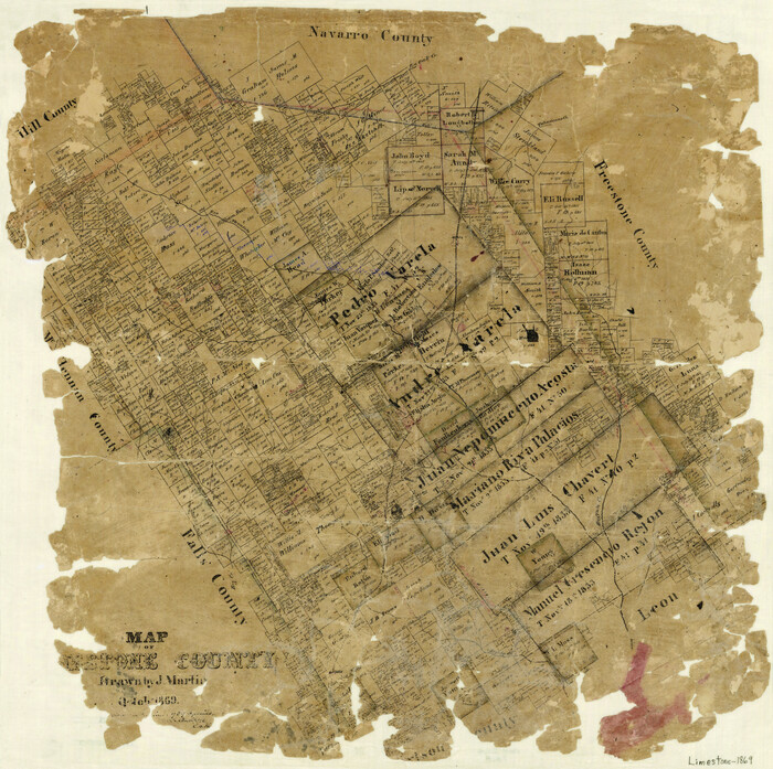
Map of Limestone County
Print $20.00
- Digital $50.00
Map of Limestone County
1869
Size 22.1 x 22.4 inches
Map/Doc 3818
Bastrop County Working Sketch 10

Print $20.00
- Digital $50.00
Bastrop County Working Sketch 10
1968
Size 31.9 x 37.7 inches
Map/Doc 67310
Clay County Sketch File 29

Print $16.00
- Digital $50.00
Clay County Sketch File 29
Size 11.3 x 8.7 inches
Map/Doc 18448
You may also like
Runnels County Sketch File 33

Print $20.00
Runnels County Sketch File 33
1892
Size 19.1 x 23.1 inches
Map/Doc 12264
Mason County Sketch File 24

Print $22.00
- Digital $50.00
Mason County Sketch File 24
1959
Size 15.0 x 15.2 inches
Map/Doc 30726
Roberts County Rolled Sketch 4

Print $52.00
- Digital $50.00
Roberts County Rolled Sketch 4
2006
Size 66.9 x 20.0 inches
Map/Doc 83620
Map of Brazoria County

Print $20.00
- Digital $50.00
Map of Brazoria County
1883
Size 26.8 x 25.6 inches
Map/Doc 861
Cameron County Aerial Photograph Index Sheet 5

Print $20.00
- Digital $50.00
Cameron County Aerial Photograph Index Sheet 5
1955
Size 18.8 x 17.8 inches
Map/Doc 83677
Chambers County Rolled Sketch 12C

Print $97.00
- Digital $50.00
Chambers County Rolled Sketch 12C
Size 10.0 x 15.2 inches
Map/Doc 43939
Harris County Sketch File 62

Print $14.00
- Digital $50.00
Harris County Sketch File 62
1930
Size 11.4 x 8.7 inches
Map/Doc 25486
General Highway Map, Milam County, Texas

Print $20.00
General Highway Map, Milam County, Texas
1940
Size 18.5 x 24.8 inches
Map/Doc 79198
Flight Mission No. DQO-2K, Frame 99, Galveston County

Print $20.00
- Digital $50.00
Flight Mission No. DQO-2K, Frame 99, Galveston County
1952
Size 18.8 x 22.5 inches
Map/Doc 85026

[Capitol Leagues in Northwest Lamb and Northeast Bailey Counties]
![91071, [Capitol Leagues in Northwest Lamb and Northeast Bailey Counties], Twichell Survey Records](https://historictexasmaps.com/wmedia_w700/maps/91071-1.tif.jpg)
Print $20.00
- Digital $50.00
[Capitol Leagues in Northwest Lamb and Northeast Bailey Counties]
Size 28.1 x 19.7 inches
Map/Doc 91071
United States - Gulf Coast Texas - Southern part of Laguna Madre

Print $20.00
- Digital $50.00
United States - Gulf Coast Texas - Southern part of Laguna Madre
1941
Size 27.0 x 18.3 inches
Map/Doc 72953