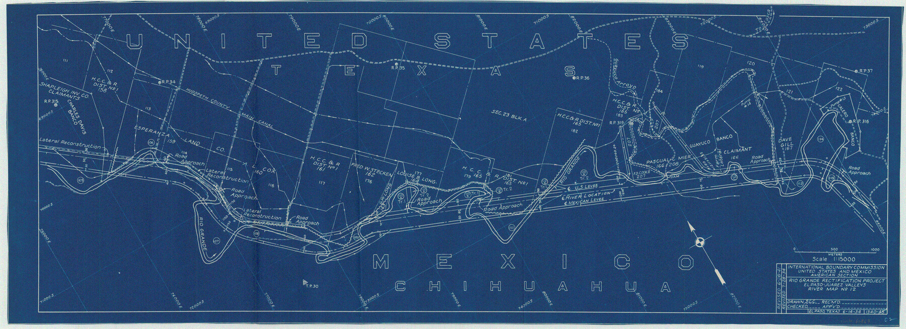
Rio Grande Rectification Project, El Paso and Juarez Valley
Rio Grande from El Paso-Hudspeth Co. line east to about Quitman Canyon
N-1-9
-
Map/Doc
60869
-
Collection
General Map Collection
-
Object Dates
1935 (Creation Date)
-
Subjects
River Surveys Texas Boundaries
-
Height x Width
10.7 x 29.5 inches
27.2 x 74.9 cm
Part of: General Map Collection
Culberson County Working Sketch 42

Print $40.00
- Digital $50.00
Culberson County Working Sketch 42
1970
Size 49.1 x 44.0 inches
Map/Doc 68496
Jeff Davis County Working Sketch 12

Print $20.00
- Digital $50.00
Jeff Davis County Working Sketch 12
1948
Size 21.5 x 29.0 inches
Map/Doc 66507
Red River County Working Sketch 77

Print $20.00
- Digital $50.00
Red River County Working Sketch 77
1981
Size 34.9 x 23.8 inches
Map/Doc 72060
Glasscock County Working Sketch 9

Print $40.00
- Digital $50.00
Glasscock County Working Sketch 9
1957
Size 77.9 x 25.5 inches
Map/Doc 63182
Hockley County Working Sketch 1

Print $40.00
- Digital $50.00
Hockley County Working Sketch 1
1946
Size 26.0 x 60.9 inches
Map/Doc 66191
Liberty County Sketch File 50

Print $42.00
- Digital $50.00
Liberty County Sketch File 50
1879
Size 12.6 x 8.4 inches
Map/Doc 30014
Flight Mission No. BRA-16M, Frame 144, Jefferson County

Print $20.00
- Digital $50.00
Flight Mission No. BRA-16M, Frame 144, Jefferson County
1953
Size 18.6 x 22.5 inches
Map/Doc 85750
Anderson County Working Sketch 33

Print $20.00
- Digital $50.00
Anderson County Working Sketch 33
1966
Size 30.8 x 29.9 inches
Map/Doc 67033
Kimble County Rolled Sketch 25

Print $20.00
- Digital $50.00
Kimble County Rolled Sketch 25
1960
Size 26.1 x 28.3 inches
Map/Doc 6515
Duval County Rolled Sketch 22

Print $20.00
- Digital $50.00
Duval County Rolled Sketch 22
1942
Size 19.5 x 30.0 inches
Map/Doc 5741
Flight Mission No. DAG-17K, Frame 64, Matagorda County

Print $20.00
- Digital $50.00
Flight Mission No. DAG-17K, Frame 64, Matagorda County
1952
Size 16.5 x 16.4 inches
Map/Doc 86326
Atascosa County Sketch File 26

Print $4.00
- Digital $50.00
Atascosa County Sketch File 26
Size 8.2 x 12.7 inches
Map/Doc 13794
You may also like
Colton's "New Medium" Map of the State of Texas, the Indian Territory, etc. from the latest & most authentic sources

Print $20.00
- Digital $50.00
Colton's "New Medium" Map of the State of Texas, the Indian Territory, etc. from the latest & most authentic sources
1884
Size 25.4 x 29.5 inches
Map/Doc 96524
Roberts County Working Sketch Graphic Index

Print $20.00
- Digital $50.00
Roberts County Working Sketch Graphic Index
1932
Size 41.2 x 37.3 inches
Map/Doc 76684
Tom Green County Working Sketch 14

Print $20.00
- Digital $50.00
Tom Green County Working Sketch 14
1982
Size 32.7 x 22.7 inches
Map/Doc 69383
Duval County Sketch File 4d

Print $4.00
- Digital $50.00
Duval County Sketch File 4d
1874
Size 10.8 x 8.7 inches
Map/Doc 21288
Jeff Davis County Working Sketch 30

Print $20.00
- Digital $50.00
Jeff Davis County Working Sketch 30
1969
Size 36.1 x 31.2 inches
Map/Doc 66525
[Public Domain Surrounded by Blocks Z, C4, C3, A2, 1]
![92427, [Public Domain Surrounded by Blocks Z, C4, C3, A2, 1], Twichell Survey Records](https://historictexasmaps.com/wmedia_w700/maps/92427-1.tif.jpg)
Print $20.00
- Digital $50.00
[Public Domain Surrounded by Blocks Z, C4, C3, A2, 1]
Size 22.5 x 26.3 inches
Map/Doc 92427
Flight Mission No. BQY-4M, Frame 70, Harris County

Print $20.00
- Digital $50.00
Flight Mission No. BQY-4M, Frame 70, Harris County
1953
Size 18.7 x 22.4 inches
Map/Doc 85279
Coleman County Working Sketch 23
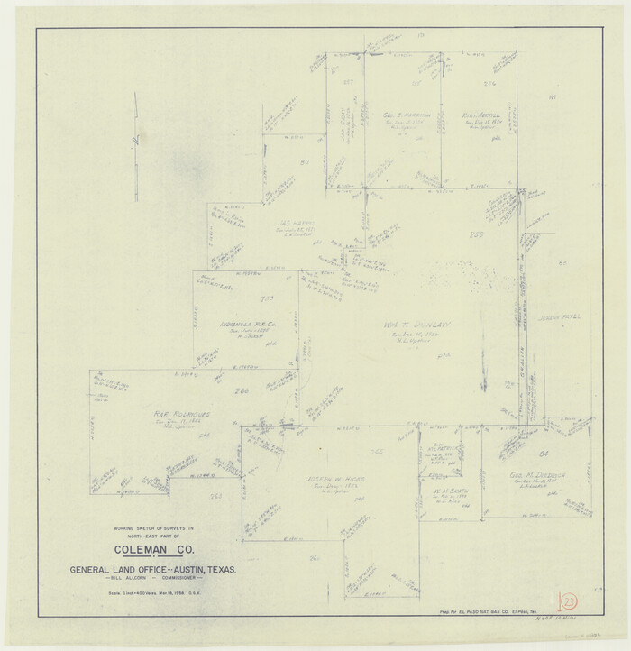
Print $20.00
- Digital $50.00
Coleman County Working Sketch 23
1958
Size 30.4 x 29.5 inches
Map/Doc 68276
Sutton County Working Sketch 17

Print $20.00
- Digital $50.00
Sutton County Working Sketch 17
1975
Size 34.0 x 27.2 inches
Map/Doc 62360
General Highway Map, Lamar County, Texas

Print $20.00
General Highway Map, Lamar County, Texas
1961
Size 24.6 x 18.2 inches
Map/Doc 79561

Hall County Sketch File 36

Print $4.00
- Digital $50.00
Hall County Sketch File 36
1914
Size 11.2 x 8.8 inches
Map/Doc 24895