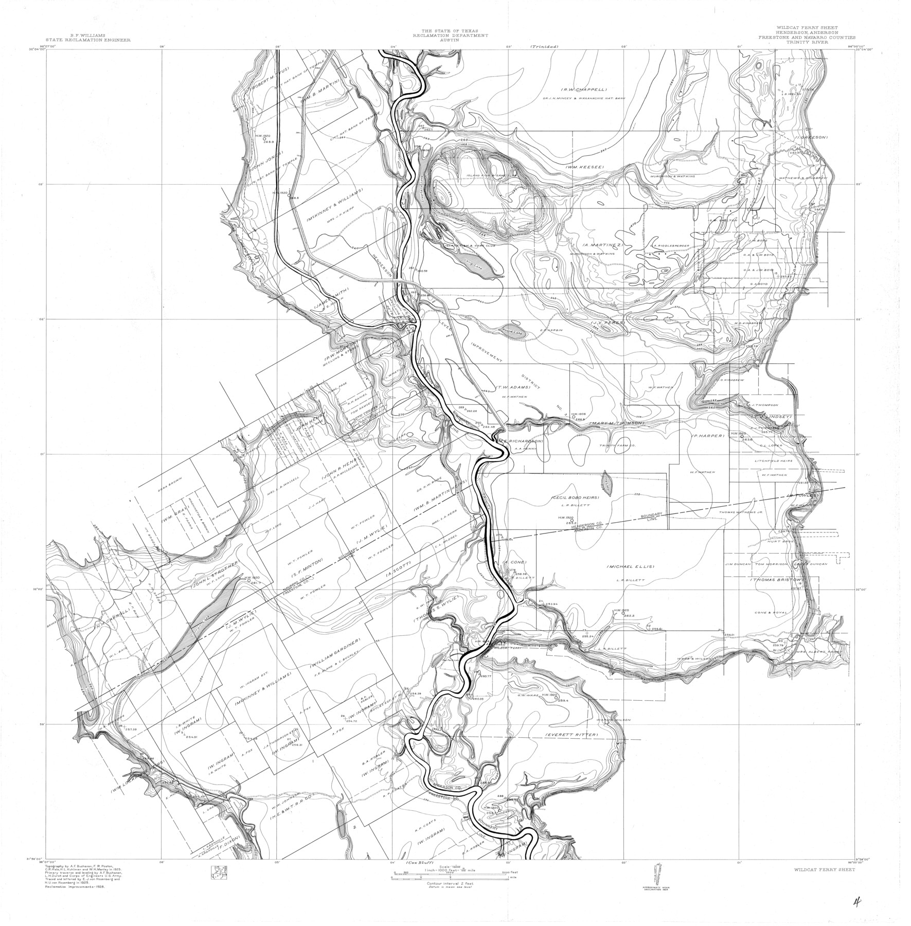
Trinity River, Wildcat Ferry Sheet
-
Map/Doc
65182
-
Collection
General Map Collection
-
Object Dates
1928 (Creation Date)
-
People and Organizations
Texas State Reclamation Department (Publisher)
Curtis R. Hale (Surveyor/Engineer)
H.U. von Rosenberg (Compiler)
E.J. von Rosenberg (Compiler)
H.U. von Rosenberg (Draftsman)
E.J. von Rosenberg (Draftsman)
H.L. Kuhlman (Surveyor/Engineer)
W.H. Manley (Surveyor/Engineer)
F.R. Poston (Surveyor/Engineer)
A.F. Buchanan (Surveyor/Engineer)
-
Counties
Henderson Anderson Freestone Navarro
-
Subjects
River Surveys Topographic
-
Height x Width
41.5 x 40.9 inches
105.4 x 103.9 cm
-
Comments
Wildcat Ferry Sheet located north of the Trinidad Sheet and south of the Cox Bluff Sheet.
Part of: General Map Collection
Flight Mission No. DQN-5K, Frame 50, Calhoun County

Print $20.00
- Digital $50.00
Flight Mission No. DQN-5K, Frame 50, Calhoun County
1953
Size 18.5 x 22.3 inches
Map/Doc 84395
Real County Working Sketch 25

Print $20.00
- Digital $50.00
Real County Working Sketch 25
1946
Size 26.5 x 24.7 inches
Map/Doc 71917
Crane County Working Sketch 20

Print $40.00
- Digital $50.00
Crane County Working Sketch 20
1958
Size 61.8 x 38.1 inches
Map/Doc 68297
Castro County Working Sketch 3

Print $20.00
- Digital $50.00
Castro County Working Sketch 3
Size 31.7 x 17.9 inches
Map/Doc 67898
Hartley County Sketch File 5

Print $8.00
- Digital $50.00
Hartley County Sketch File 5
1883
Size 12.7 x 8.1 inches
Map/Doc 26090
Flight Mission No. BRE-1P, Frame 27, Nueces County

Print $20.00
- Digital $50.00
Flight Mission No. BRE-1P, Frame 27, Nueces County
1956
Size 18.5 x 22.4 inches
Map/Doc 86622
Crane County Sketch File 19

Print $4.00
- Digital $50.00
Crane County Sketch File 19
1927
Size 11.4 x 8.8 inches
Map/Doc 19584
Cottle County Sketch File F

Print $6.00
- Digital $50.00
Cottle County Sketch File F
1935
Size 11.5 x 8.8 inches
Map/Doc 19444
Travis County Appraisal District Plat Map 2_3016

Print $20.00
- Digital $50.00
Travis County Appraisal District Plat Map 2_3016
Size 21.5 x 26.4 inches
Map/Doc 94221
Flight Mission No. BQR-3K, Frame 83, Brazoria County

Print $20.00
- Digital $50.00
Flight Mission No. BQR-3K, Frame 83, Brazoria County
1952
Size 18.7 x 22.4 inches
Map/Doc 83975
Right of Way Track Map, Wichita Falls & Southern Railroad Company

Print $40.00
- Digital $50.00
Right of Way Track Map, Wichita Falls & Southern Railroad Company
1942
Size 24.5 x 56.1 inches
Map/Doc 64514

You may also like
Hall County Sketch File 24

Print $10.00
- Digital $50.00
Hall County Sketch File 24
1911
Size 11.2 x 8.6 inches
Map/Doc 24817
Amistad International Reservoir on Rio Grande 85

Print $20.00
- Digital $50.00
Amistad International Reservoir on Rio Grande 85
1949
Size 28.4 x 40.2 inches
Map/Doc 75514
Atascosa County Working Sketch 4

Print $20.00
- Digital $50.00
Atascosa County Working Sketch 4
1913
Size 16.8 x 15.0 inches
Map/Doc 67199
Index sheet to accompany map of survey for connecting the inland waters along margin of the Gulf of Mexico from Donaldsonville in Louisiana to the Rio Grande River in Texas

Print $20.00
- Digital $50.00
Index sheet to accompany map of survey for connecting the inland waters along margin of the Gulf of Mexico from Donaldsonville in Louisiana to the Rio Grande River in Texas
1873
Size 18.2 x 28.2 inches
Map/Doc 72693
Wood County Rolled Sketch 2

Print $40.00
- Digital $50.00
Wood County Rolled Sketch 2
1941
Size 52.6 x 24.9 inches
Map/Doc 10160
Presidio County Rolled Sketch 89

Print $20.00
- Digital $50.00
Presidio County Rolled Sketch 89
1946
Size 34.4 x 25.5 inches
Map/Doc 7374
Liberty County Sketch File 30

Print $6.00
- Digital $50.00
Liberty County Sketch File 30
Size 10.5 x 11.3 inches
Map/Doc 29957
St. Louis, Brownsville & Mexico Railway Location Map from Mile 20 to Mile 40

Print $40.00
- Digital $50.00
St. Louis, Brownsville & Mexico Railway Location Map from Mile 20 to Mile 40
1905
Size 19.2 x 61.4 inches
Map/Doc 64078
Upton County Rolled Sketch 44

Print $40.00
- Digital $50.00
Upton County Rolled Sketch 44
1955
Size 43.2 x 55.4 inches
Map/Doc 75945
Map of Kerr County

Print $40.00
- Digital $50.00
Map of Kerr County
1895
Size 39.7 x 48.9 inches
Map/Doc 5002
Grimes County Working Sketch 2

Print $20.00
- Digital $50.00
Grimes County Working Sketch 2
1941
Size 13.2 x 20.9 inches
Map/Doc 63293
[E. T. Ry. Blk. 1]
![89795, [E. T. Ry. Blk. 1], Twichell Survey Records](https://historictexasmaps.com/wmedia_w700/maps/89795-1.tif.jpg)
Print $40.00
- Digital $50.00
[E. T. Ry. Blk. 1]
Size 40.6 x 51.2 inches
Map/Doc 89795