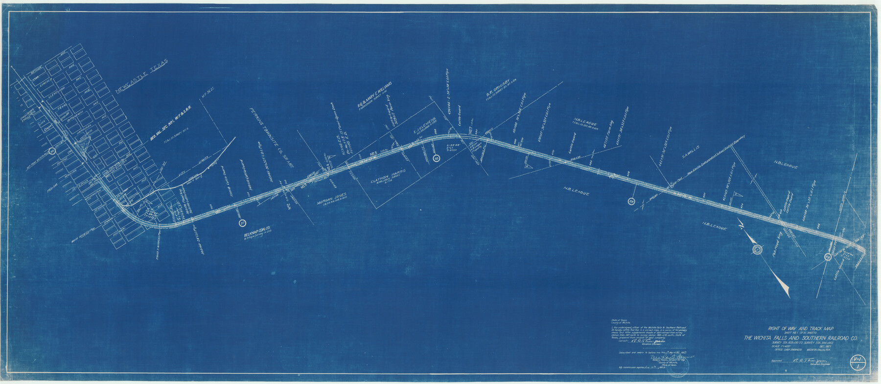
Right of Way Track Map, Wichita Falls & Southern Railroad Company
Z-2-160
-
Map/Doc
64514
-
Collection
General Map Collection
-
Object Dates
1927
1942 (Creation Date)
-
Counties
Young
-
Subjects
Railroads
-
Height x Width
24.5 x 56.1 inches
62.2 x 142.5 cm
-
Medium
blueprint/diazo
-
Scale
1"=400'
-
Comments
Sheet No. 1 of 10 sheets. Survey Sta. 603+00 to Survey Sta. 394+657. See counter nos. 64515 through 64521 for other sheets.
-
Features
WF&S
Arthur Avenue
Lincoln Avenue
Newcastle
Cleveland Avenue
Texas Avenue
Broadway Avenue
Harrison Avenue
Monroe Avenue
Madison Avenue
Jefferson Avenue
Washington Avenue
Jennings Avenue
Evans Avenue
Missouri Avenue
Part of: General Map Collection
Flight Mission No. CUG-2P, Frame 76, Kleberg County

Print $20.00
- Digital $50.00
Flight Mission No. CUG-2P, Frame 76, Kleberg County
1956
Size 18.4 x 22.1 inches
Map/Doc 86208
Coast Chart No. 210 Aransas Pass and Corpus Christi Bay with the coast to latitude 27° 12' Texas

Print $20.00
- Digital $50.00
Coast Chart No. 210 Aransas Pass and Corpus Christi Bay with the coast to latitude 27° 12' Texas
1887
Size 27.1 x 18.3 inches
Map/Doc 72804
Motley County Sketch File 3 (S)

Print $6.00
- Digital $50.00
Motley County Sketch File 3 (S)
Size 9.5 x 13.0 inches
Map/Doc 32141
Starr County Working Sketch 19

Print $20.00
- Digital $50.00
Starr County Working Sketch 19
1982
Size 27.3 x 33.9 inches
Map/Doc 63935
Trinity River, Bazzette Sheet

Print $4.00
- Digital $50.00
Trinity River, Bazzette Sheet
1925
Size 28.2 x 24.9 inches
Map/Doc 65218

McMullen County Working Sketch 53

Print $20.00
- Digital $50.00
McMullen County Working Sketch 53
1983
Size 18.1 x 18.7 inches
Map/Doc 70754
Burnet County Sketch File 14a

Print $6.00
- Digital $50.00
Burnet County Sketch File 14a
Size 17.0 x 11.0 inches
Map/Doc 16700
A New Map of the Whole Continent of America. Divided into North and South and West Indies, wherein are exactly decribed the United States of North America as well as the Several European Possessions according to the Preliminaries of Peace…

Print $40.00
- Digital $50.00
A New Map of the Whole Continent of America. Divided into North and South and West Indies, wherein are exactly decribed the United States of North America as well as the Several European Possessions according to the Preliminaries of Peace…
Size 22.0 x 48.7 inches
Map/Doc 95136

Flight Mission No. CON-4R, Frame 143, Stonewall County

Print $20.00
- Digital $50.00
Flight Mission No. CON-4R, Frame 143, Stonewall County
1957
Size 18.3 x 22.0 inches
Map/Doc 86993
Travis County Rolled Sketch 36

Print $20.00
- Digital $50.00
Travis County Rolled Sketch 36
Size 33.9 x 24.5 inches
Map/Doc 8037
You may also like
Section 1, Block AX, Gaines County, Texas

Print $3.00
- Digital $50.00
Section 1, Block AX, Gaines County, Texas
1952
Size 11.1 x 13.1 inches
Map/Doc 92670
[Right of Way Map, Belton Branch of the M.K.&T. RR.]
![64223, [Right of Way Map, Belton Branch of the M.K.&T. RR.], General Map Collection](https://historictexasmaps.com/wmedia_w700/maps/64223.tif.jpg)
Print $20.00
- Digital $50.00
[Right of Way Map, Belton Branch of the M.K.&T. RR.]
1896
Size 21.7 x 7.2 inches
Map/Doc 64223
Nueces County Rolled Sketch 58

Print $50.00
Nueces County Rolled Sketch 58
1979
Size 28.2 x 40.1 inches
Map/Doc 6899
Orange County Working Sketch 17

Print $20.00
- Digital $50.00
Orange County Working Sketch 17
1930
Size 35.6 x 26.1 inches
Map/Doc 71349
The Chief Justice County of Jackson. April 24, 1837

Print $20.00
The Chief Justice County of Jackson. April 24, 1837
2020
Size 18.4 x 21.7 inches
Map/Doc 96051
Parker County Sketch File 19

Print $6.00
- Digital $50.00
Parker County Sketch File 19
1876
Size 11.7 x 10.3 inches
Map/Doc 33556
[Portion of sketch showing alleged vacancy]
![91953, [Portion of sketch showing alleged vacancy], Twichell Survey Records](https://historictexasmaps.com/wmedia_w700/maps/91953-1.tif.jpg)
Print $20.00
- Digital $50.00
[Portion of sketch showing alleged vacancy]
Size 18.9 x 24.4 inches
Map/Doc 91953
Brazoria County Rolled Sketch 45

Print $4.00
- Digital $50.00
Brazoria County Rolled Sketch 45
1885
Size 23.0 x 28.5 inches
Map/Doc 5179
Wichita County Sketch File 14

Print $20.00
- Digital $50.00
Wichita County Sketch File 14
1885
Size 17.7 x 17.0 inches
Map/Doc 12678
[Surveys in the Harris District at Clear Lake]
![276, [Surveys in the Harris District at Clear Lake], General Map Collection](https://historictexasmaps.com/wmedia_w700/maps/276-1.tif.jpg)
Print $2.00
- Digital $50.00
[Surveys in the Harris District at Clear Lake]
1840
Size 6.7 x 10.5 inches
Map/Doc 276
Working Sketch Archer County

Print $20.00
- Digital $50.00
Working Sketch Archer County
1924
Size 26.6 x 20.5 inches
Map/Doc 90257
[Blocks S2, K3, K, and S1]
![90415, [Blocks S2, K3, K, and S1], Twichell Survey Records](https://historictexasmaps.com/wmedia_w700/maps/90415-1.tif.jpg)
Print $20.00
- Digital $50.00
[Blocks S2, K3, K, and S1]
1906
Size 17.9 x 16.4 inches
Map/Doc 90415