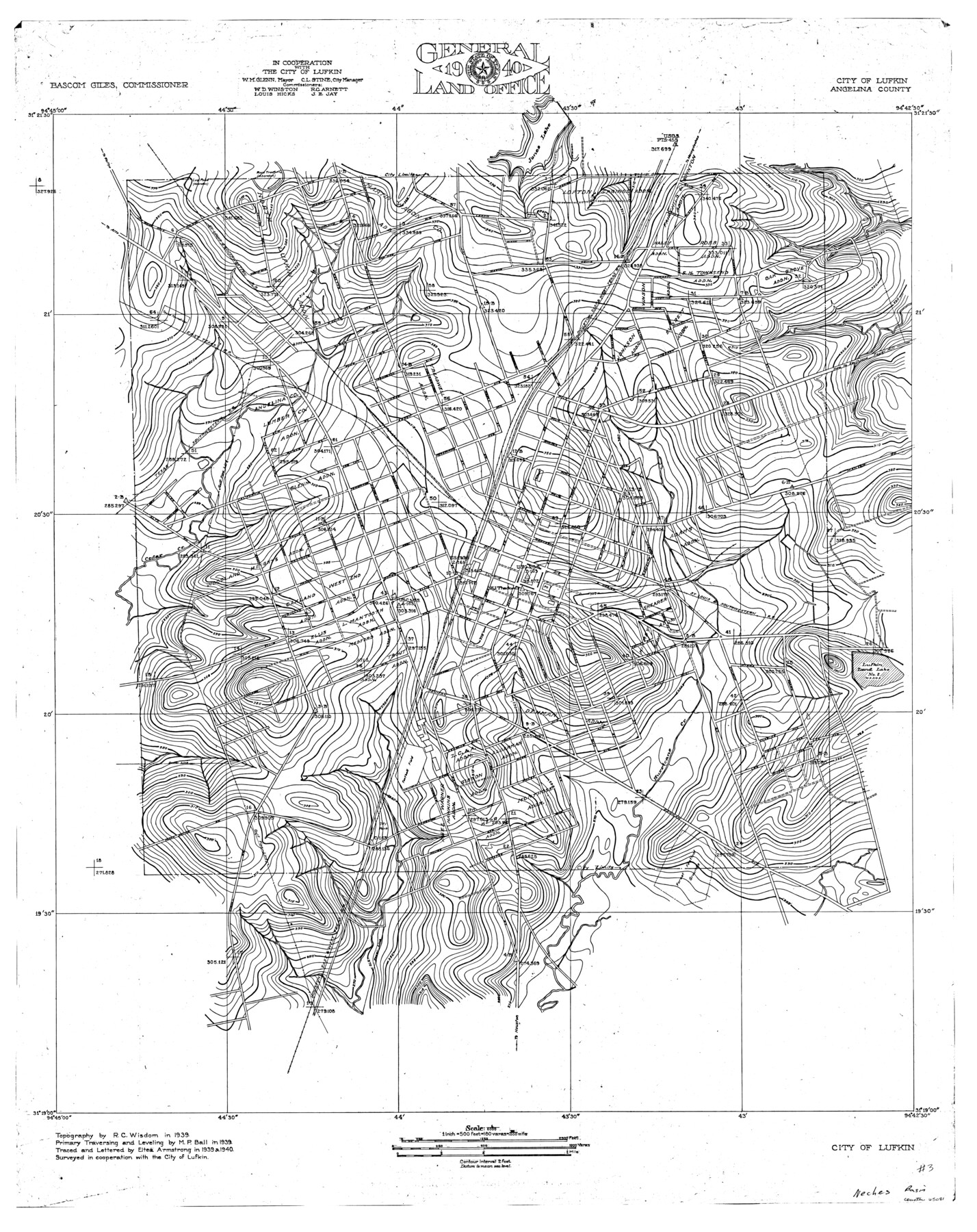
Neches River, City of Lufkin
-
Map/Doc
65081
-
Collection
General Map Collection
-
Object Dates
1940 (Creation Date)
-
People and Organizations
Texas General Land Office (Publisher)
Eltea Armstrong (Draftsman)
Bascom Giles (GLO Commissioner)
Eltea Armstrong (Compiler)
M.P. Ball (Surveyor/Engineer)
R.C. Wisdom (Surveyor/Engineer)
-
Counties
Angelina
-
Subjects
City River Surveys
-
Height x Width
37.5 x 29.7 inches
95.3 x 75.4 cm
Part of: General Map Collection
Pecos County Rolled Sketch 172

Print $453.00
- Digital $50.00
Pecos County Rolled Sketch 172
Size 10.4 x 15.0 inches
Map/Doc 48632
Jackson County Working Sketch 12

Print $20.00
- Digital $50.00
Jackson County Working Sketch 12
Size 31.2 x 33.0 inches
Map/Doc 66460
Roberts County

Print $20.00
- Digital $50.00
Roberts County
1884
Size 20.3 x 18.2 inches
Map/Doc 3992
Potter County Working Sketch Graphic Index

Print $20.00
- Digital $50.00
Potter County Working Sketch Graphic Index
1960
Size 42.3 x 33.1 inches
Map/Doc 76669
Brewster County Rolled Sketch 157

Print $20.00
- Digital $50.00
Brewster County Rolled Sketch 157
2008
Size 36.6 x 24.8 inches
Map/Doc 88870
Flight Mission No. DIX-5P, Frame 152, Aransas County

Print $20.00
- Digital $50.00
Flight Mission No. DIX-5P, Frame 152, Aransas County
1956
Size 17.8 x 18.6 inches
Map/Doc 83814
Fort Bend County Sketch File 4a

Print $40.00
- Digital $50.00
Fort Bend County Sketch File 4a
1887
Size 15.8 x 12.3 inches
Map/Doc 22887
Burnet County Sketch File 24

Print $8.00
- Digital $50.00
Burnet County Sketch File 24
1872
Size 7.9 x 10.2 inches
Map/Doc 16721
PSL Field Notes for Blocks 110 through 122 in Culberson County and Block 123 in Hudspeth County

PSL Field Notes for Blocks 110 through 122 in Culberson County and Block 123 in Hudspeth County
Map/Doc 81666
Freestone County Rolled Sketch 3

Print $67.00
- Digital $50.00
Freestone County Rolled Sketch 3
Size 10.4 x 15.5 inches
Map/Doc 44784
Schleicher County Sketch File 21

Print $40.00
- Digital $50.00
Schleicher County Sketch File 21
1936
Size 14.5 x 15.2 inches
Map/Doc 36510
Copy of Surveyor's Field Book, Morris Browning - In Blocks 7, 5 & 4, I&GNRRCo., Hutchinson and Carson Counties, Texas

Print $2.00
- Digital $50.00
Copy of Surveyor's Field Book, Morris Browning - In Blocks 7, 5 & 4, I&GNRRCo., Hutchinson and Carson Counties, Texas
1888
Size 8.9 x 7.1 inches
Map/Doc 62287
You may also like
Borden County Sketch File 11

Print $4.00
- Digital $50.00
Borden County Sketch File 11
1892
Size 11.0 x 8.9 inches
Map/Doc 14730
Harris County Working Sketch 44

Print $20.00
- Digital $50.00
Harris County Working Sketch 44
1941
Size 24.9 x 38.3 inches
Map/Doc 65936
Edwards County Sketch File 26

Print $4.00
- Digital $50.00
Edwards County Sketch File 26
1910
Size 11.5 x 9.2 inches
Map/Doc 21753
Bird's Eye View of Abilene, Taylor County, Texas

Print $20.00
Bird's Eye View of Abilene, Taylor County, Texas
1883
Size 23.6 x 30.7 inches
Map/Doc 89071
Bandera County Working Sketch 40

Print $20.00
- Digital $50.00
Bandera County Working Sketch 40
1977
Size 29.9 x 23.7 inches
Map/Doc 67636
Burleson County Working Sketch 37

Print $20.00
- Digital $50.00
Burleson County Working Sketch 37
1982
Size 33.7 x 44.3 inches
Map/Doc 67756
Menard County Working Sketch 8

Print $20.00
- Digital $50.00
Menard County Working Sketch 8
1928
Size 19.2 x 15.7 inches
Map/Doc 70955
Blanco County Working Sketch 29

Print $40.00
- Digital $50.00
Blanco County Working Sketch 29
1969
Size 52.4 x 33.4 inches
Map/Doc 67389
Frio County Working Sketch 25

Print $40.00
- Digital $50.00
Frio County Working Sketch 25
1989
Size 35.4 x 50.0 inches
Map/Doc 69299
Leon County Working Sketch 44

Print $40.00
- Digital $50.00
Leon County Working Sketch 44
1980
Size 42.8 x 59.8 inches
Map/Doc 70443
McLennan County Sketch File 22

Print $3.00
- Digital $50.00
McLennan County Sketch File 22
1869
Size 11.1 x 9.3 inches
Map/Doc 31296
Mills County Boundary File 3

Print $30.00
- Digital $50.00
Mills County Boundary File 3
Size 11.0 x 8.6 inches
Map/Doc 57281