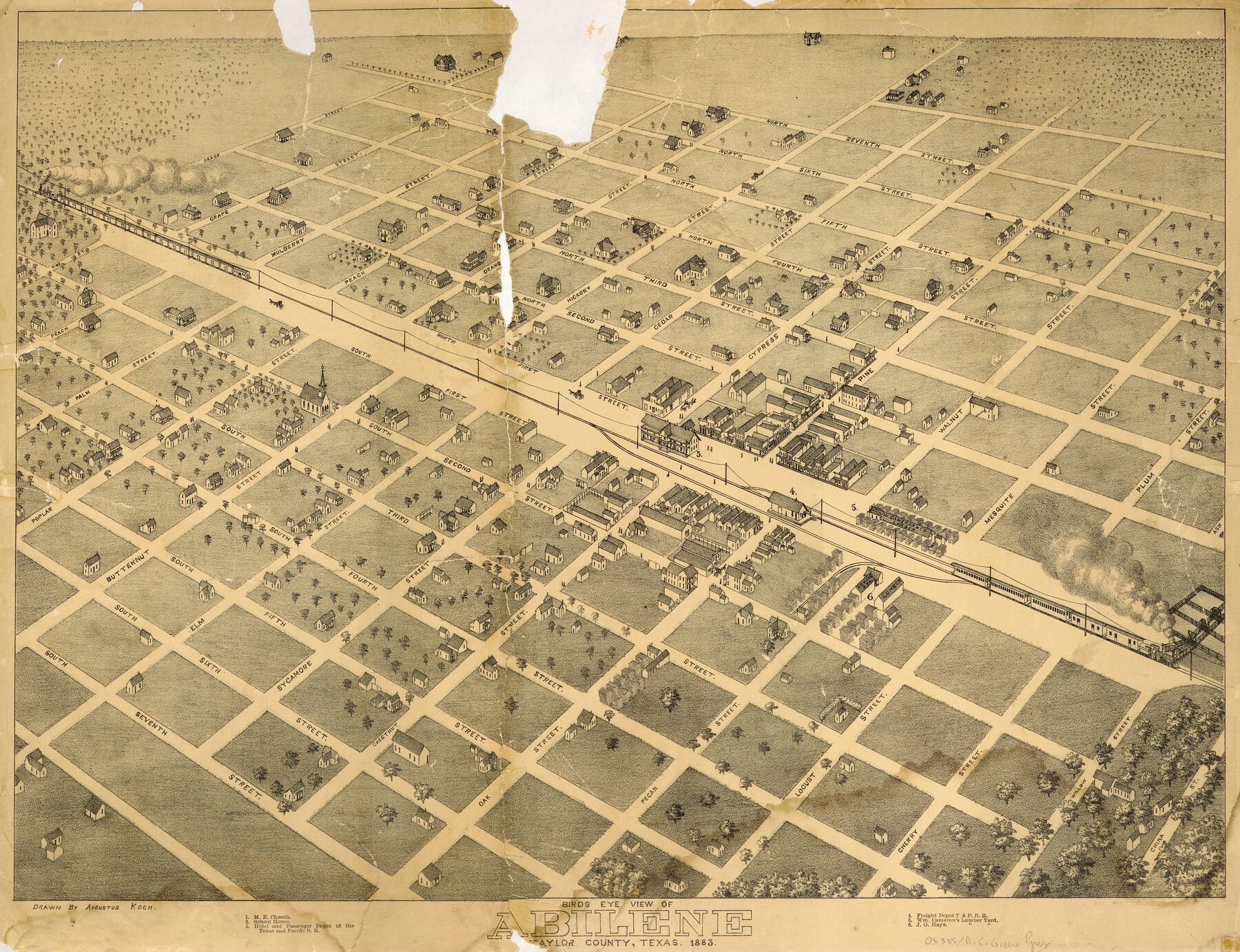
Bird's Eye View of Abilene, Taylor County, Texas
-
Map/Doc
89071
-
Collection
Non-GLO Digital Images
-
Object Dates
1883 (Creation Date)
-
People and Organizations
Augustus Koch (Author)
-
Counties
Taylor
-
Subjects
Bird's Eye View City Pictorial
-
Height x Width
23.6 x 30.7 inches
59.9 x 78.0 cm
-
Comments
Bird's Eye View map. Public Domain image obtained from Wikimedia Commons.
Part of: Non-GLO Digital Images
Bird's Eye View of Corpus Christi

Print $20.00
Bird's Eye View of Corpus Christi
1887
Size 21.4 x 28.0 inches
Map/Doc 94113

Bird's Eye View of Abilene, Taylor County, Texas

Print $20.00
Bird's Eye View of Abilene, Taylor County, Texas
1883
Size 23.6 x 30.7 inches
Map/Doc 89071

County Map of Texas, and Indian Territory

Print $20.00
County Map of Texas, and Indian Territory
1872
Size 18.9 x 16.1 inches
Map/Doc 88820

Map of the territory comprised between the Province of New Mexico and the fort of Natchitoches and Texas

Map of the territory comprised between the Province of New Mexico and the fort of Natchitoches and Texas
1789
Size 8.9 x 15.3 inches
Map/Doc 88888
Rain Chart of the United States showing by isohyetal lines the distribution of the mean annual precipitation in rain and melted snow

Print $20.00
Rain Chart of the United States showing by isohyetal lines the distribution of the mean annual precipitation in rain and melted snow
1878
Size 20.8 x 29.4 inches
Map/Doc 95190
The Official Map of the City of El Paso, State of Texas

Print $40.00
The Official Map of the City of El Paso, State of Texas
1889
Size 83.6 x 97.2 inches
Map/Doc 89619
Bird's Eye View of the City of Waco

Print $20.00
Bird's Eye View of the City of Waco
1873
Size 19.6 x 24.0 inches
Map/Doc 89211
Perspective Map of the City of Laredo, Texas, the Gateway to and from Mexico

Print $20.00
Perspective Map of the City of Laredo, Texas, the Gateway to and from Mexico
1892
Size 22.1 x 34.2 inches
Map/Doc 89098
Map of the United States Exhibiting the grants of lands made by the general government to aid in the construction of railroads and wagon roads

Print $20.00
Map of the United States Exhibiting the grants of lands made by the general government to aid in the construction of railroads and wagon roads
1878
Size 20.8 x 29.4 inches
Map/Doc 95286
You may also like
Crosby County Sketch File 11b

Print $20.00
- Digital $50.00
Crosby County Sketch File 11b
1890
Size 17.2 x 15.6 inches
Map/Doc 11247
Flight Mission No. CRC-2R, Frame 110, Chambers County

Print $20.00
- Digital $50.00
Flight Mission No. CRC-2R, Frame 110, Chambers County
1956
Size 18.6 x 22.3 inches
Map/Doc 84737
Caldwell County Working Sketch 6

Print $20.00
- Digital $50.00
Caldwell County Working Sketch 6
1958
Size 21.8 x 26.3 inches
Map/Doc 67836
Brown County Rolled Sketch 3

Print $20.00
- Digital $50.00
Brown County Rolled Sketch 3
1985
Size 25.0 x 36.5 inches
Map/Doc 5353
Crane County Sketch File 7

Print $6.00
- Digital $50.00
Crane County Sketch File 7
1886
Size 10.3 x 11.0 inches
Map/Doc 19567
Hemphill County Working Sketch 27

Print $40.00
- Digital $50.00
Hemphill County Working Sketch 27
1974
Size 50.7 x 43.5 inches
Map/Doc 66122
Flight Mission No. CRC-4R, Frame 175, Chambers County

Print $20.00
- Digital $50.00
Flight Mission No. CRC-4R, Frame 175, Chambers County
1956
Size 18.6 x 22.2 inches
Map/Doc 84926
Prison Property, Walker Co.

Print $20.00
- Digital $50.00
Prison Property, Walker Co.
Size 19.3 x 20.2 inches
Map/Doc 94278
Hunt County Rolled Sketch 5

Print $20.00
- Digital $50.00
Hunt County Rolled Sketch 5
1956
Size 22.9 x 23.0 inches
Map/Doc 6272
Map of the Panhandle Railway

Print $40.00
- Digital $50.00
Map of the Panhandle Railway
1888
Size 22.6 x 114.7 inches
Map/Doc 64461
Mills County Boundary File 10

Print $46.00
- Digital $50.00
Mills County Boundary File 10
Size 17.0 x 11.6 inches
Map/Doc 57329
Hockley County Sketch Mineral Application Number 39180

Print $20.00
- Digital $50.00
Hockley County Sketch Mineral Application Number 39180
1947
Size 16.1 x 20.1 inches
Map/Doc 92246