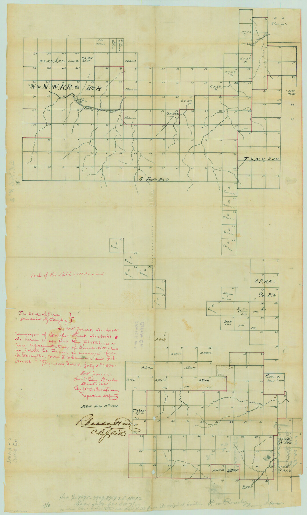
Cottle County Sketch File 2
D. H. Jones Sk. W. & N. W. RR. Co.
-
Map/Doc
76757
-
Collection
General Map Collection
-
Object Dates
7/5/1882 (Creation Date)
7/13/1882 (File Date)
-
People and Organizations
D. H. Jones (Surveyor/Engineer)
Rhoads Fisher (GLO Clerk)
-
Counties
Cottle Foard
-
Subjects
Surveying Sketch File
-
Height x Width
32.9 x 19.6 inches
83.6 x 49.8 cm
-
Medium
paper, manuscript
-
Scale
1" = 2000 varas
-
Features
North Pease River
Part of: General Map Collection
Sketch C Showing the Progress of the Survey in Section III From 1843 to 1852

Print $20.00
- Digital $50.00
Sketch C Showing the Progress of the Survey in Section III From 1843 to 1852
1852
Size 36.2 x 25.6 inches
Map/Doc 97201
Concho County Working Sketch 5

Print $20.00
- Digital $50.00
Concho County Working Sketch 5
1948
Size 41.3 x 37.9 inches
Map/Doc 68187
Chart of the West Indies and Spanish Dominions in North America

Print $20.00
- Digital $50.00
Chart of the West Indies and Spanish Dominions in North America
1803
Size 25.6 x 39.2 inches
Map/Doc 97138
Marion County Rolled Sketch 9A

Print $20.00
- Digital $50.00
Marion County Rolled Sketch 9A
2001
Size 22.9 x 22.9 inches
Map/Doc 76419
Rains County Sketch File 2

Print $4.00
- Digital $50.00
Rains County Sketch File 2
Size 10.1 x 7.4 inches
Map/Doc 34945
Duval County Sketch File 5

Print $20.00
- Digital $50.00
Duval County Sketch File 5
1860
Size 20.8 x 29.6 inches
Map/Doc 11381
Van Zandt County Working Sketch 11

Print $20.00
- Digital $50.00
Van Zandt County Working Sketch 11
1982
Size 15.2 x 9.3 inches
Map/Doc 72261
Subdivisions of University League 8 in Cooke County

Subdivisions of University League 8 in Cooke County
Map/Doc 81728
Hutchinson County Working Sketch 17

Print $40.00
- Digital $50.00
Hutchinson County Working Sketch 17
1955
Size 47.2 x 128.6 inches
Map/Doc 66375
Montague County Working Sketch 3

Print $20.00
- Digital $50.00
Montague County Working Sketch 3
1912
Size 20.5 x 15.4 inches
Map/Doc 71069
Nautical Chart 892-SC - Intracoastal Waterway - Carlos Bay to Redfish Bay including Copano Bay, Texas

Print $40.00
- Digital $50.00
Nautical Chart 892-SC - Intracoastal Waterway - Carlos Bay to Redfish Bay including Copano Bay, Texas
1972
Size 16.6 x 52.1 inches
Map/Doc 73441
Starr County Rolled Sketch 17

Print $20.00
- Digital $50.00
Starr County Rolled Sketch 17
1911
Size 26.4 x 23.1 inches
Map/Doc 7802
You may also like
Lampasas County Sketch File 5

Print $8.00
- Digital $50.00
Lampasas County Sketch File 5
1869
Size 12.8 x 7.9 inches
Map/Doc 29396
Montgomery County Rolled Sketch 17

Print $20.00
- Digital $50.00
Montgomery County Rolled Sketch 17
Size 26.6 x 34.9 inches
Map/Doc 6805
Llano County Working Sketch Graphic Index

Print $20.00
- Digital $50.00
Llano County Working Sketch Graphic Index
1943
Size 43.7 x 42.6 inches
Map/Doc 76624
Jefferson County Working Sketch 1

Print $20.00
- Digital $50.00
Jefferson County Working Sketch 1
Size 22.7 x 17.5 inches
Map/Doc 66544
A New Map of Texas with the Contiguous American & Mexican States

Print $20.00
A New Map of Texas with the Contiguous American & Mexican States
1835
Size 13.5 x 16.1 inches
Map/Doc 76185
Map of the United States and Texas Boundary Line and Adjacent Territory

Print $20.00
- Digital $50.00
Map of the United States and Texas Boundary Line and Adjacent Territory
1860
Size 26.9 x 41.4 inches
Map/Doc 2129
[Map of resurvey of H. & G.N. RR. Co. Blk. B2]
![89941, [Map of resurvey of H. & G.N. RR. Co. Blk. B2], Twichell Survey Records](https://historictexasmaps.com/wmedia_w700/maps/89941-1.tif.jpg)
Print $20.00
- Digital $50.00
[Map of resurvey of H. & G.N. RR. Co. Blk. B2]
1888
Size 36.6 x 37.7 inches
Map/Doc 89941
San Jacinto County

Print $20.00
- Digital $50.00
San Jacinto County
1942
Size 47.1 x 42.8 inches
Map/Doc 63017
Calhoun County Sketch File 11

Print $39.00
- Digital $50.00
Calhoun County Sketch File 11
1957
Size 11.4 x 8.9 inches
Map/Doc 35944
Galveston County Working Sketch 21

Print $20.00
- Digital $50.00
Galveston County Working Sketch 21
1987
Size 28.9 x 23.9 inches
Map/Doc 69358
Nueces County Sketch File 12

Print $4.00
- Digital $50.00
Nueces County Sketch File 12
1848
Size 9.8 x 8.7 inches
Map/Doc 32528
Mapa de toda la Frontera de los dominios del Rey en la America septentrional

Print $40.00
Mapa de toda la Frontera de los dominios del Rey en la America septentrional
1771
Size 26.4 x 50.0 inches
Map/Doc 95311