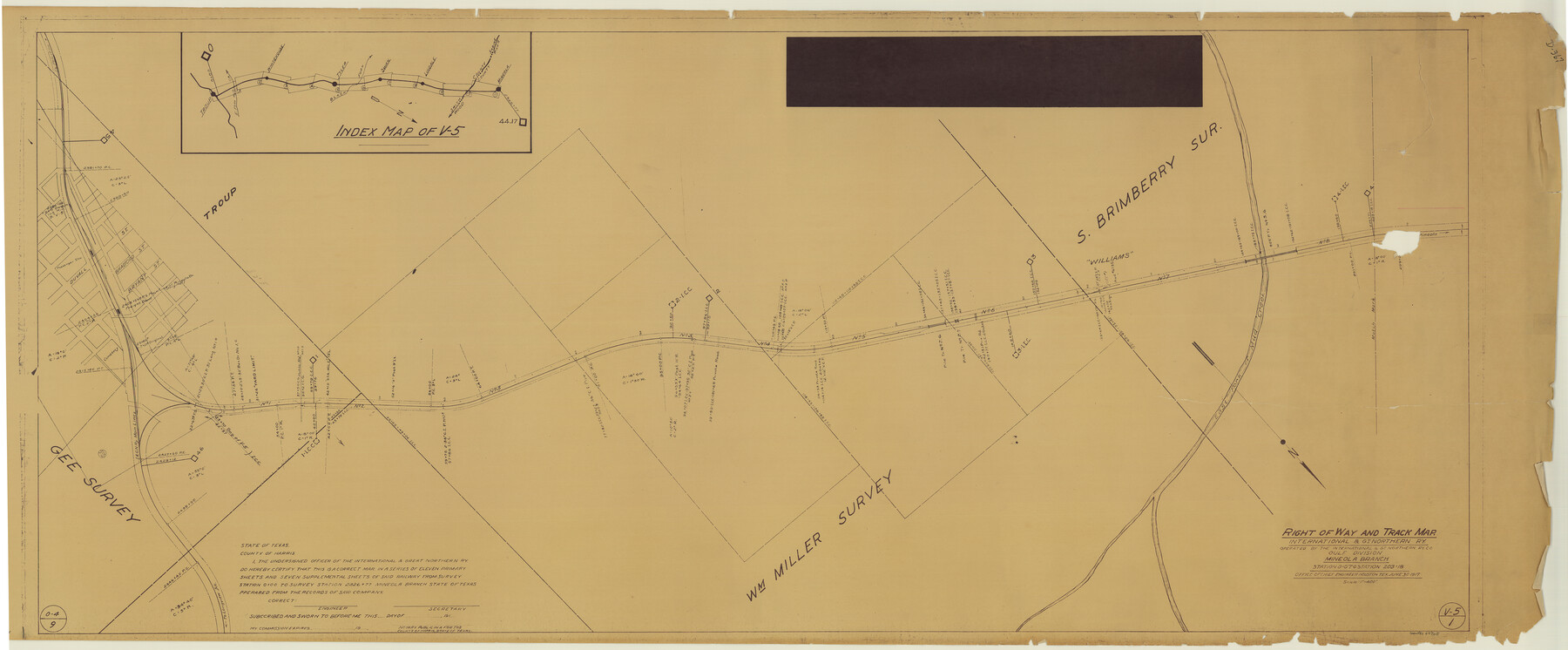
Right of Way and Track Map, International & Gt. Northern Ry. operated by the International & Gt. Northern Ry. Co. Gulf Division, Mineola Branch
Station 0+0 to Station 203+18
Z-2-198
-
Map/Doc
64705
-
Collection
General Map Collection
-
Object Dates
1917/6/30 (Creation Date)
-
People and Organizations
Office of Chief Engineer (Publisher)
-
Counties
Smith
-
Subjects
Railroads
-
Height x Width
24.9 x 60.2 inches
63.2 x 152.9 cm
-
Medium
blueprint/diazo
-
Scale
1" = 400'
-
Comments
Segment 6; see 64700 through 64704 for other segments.
-
Features
I&GN
Troup
Williams
East Fork of Mud Creek
Part of: General Map Collection
Flight Mission No. BRA-3M, Frame 118, Jefferson County

Print $20.00
- Digital $50.00
Flight Mission No. BRA-3M, Frame 118, Jefferson County
1953
Size 18.6 x 22.3 inches
Map/Doc 85392
Mills County Working Sketch 7

Print $20.00
- Digital $50.00
Mills County Working Sketch 7
1914
Size 12.8 x 13.0 inches
Map/Doc 71037
Flight Mission No. DCL-7C, Frame 22, Kenedy County

Print $20.00
- Digital $50.00
Flight Mission No. DCL-7C, Frame 22, Kenedy County
1943
Size 15.4 x 15.2 inches
Map/Doc 86014
Morris County Sketch File 5

Print $20.00
- Digital $50.00
Morris County Sketch File 5
Size 21.4 x 11.6 inches
Map/Doc 42132
Upshur County Sketch File 13B

Print $20.00
- Digital $50.00
Upshur County Sketch File 13B
1936
Size 20.5 x 32.3 inches
Map/Doc 12504
Lynn County Rolled Sketch WR

Print $20.00
- Digital $50.00
Lynn County Rolled Sketch WR
Size 14.7 x 23.8 inches
Map/Doc 6656
Refugio County Working Sketch 7

Print $20.00
- Digital $50.00
Refugio County Working Sketch 7
1939
Size 21.3 x 23.2 inches
Map/Doc 63516
[Surveys in Austin's Colony along the Navasota River and Ten Mile Creek]
![80, [Surveys in Austin's Colony along the Navasota River and Ten Mile Creek], General Map Collection](https://historictexasmaps.com/wmedia_w700/maps/80.tif.jpg)
Print $20.00
- Digital $50.00
[Surveys in Austin's Colony along the Navasota River and Ten Mile Creek]
1821
Size 29.2 x 18.0 inches
Map/Doc 80
Crockett County Working Sketch 6

Print $20.00
- Digital $50.00
Crockett County Working Sketch 6
Size 20.7 x 21.7 inches
Map/Doc 68339
Cass County Working Sketch 4

Print $20.00
- Digital $50.00
Cass County Working Sketch 4
1936
Size 33.7 x 29.1 inches
Map/Doc 67907
Roberts County Boundary File 2d

Print $20.00
- Digital $50.00
Roberts County Boundary File 2d
Size 9.1 x 28.1 inches
Map/Doc 58366
Mills County Working Sketch 11

Print $20.00
- Digital $50.00
Mills County Working Sketch 11
1930
Size 22.5 x 14.4 inches
Map/Doc 71041
You may also like
Galveston County Sketch File 58

Print $20.00
- Digital $50.00
Galveston County Sketch File 58
1984
Size 47.1 x 38.3 inches
Map/Doc 10458
Fannin County Boundary File 5

Print $44.00
- Digital $50.00
Fannin County Boundary File 5
Size 22.3 x 7.7 inches
Map/Doc 53309
Nueces County NRC Article 33.136 Sketch 6

Print $44.00
- Digital $50.00
Nueces County NRC Article 33.136 Sketch 6
2002
Size 23.4 x 35.2 inches
Map/Doc 78658
Anderson County Boundary File 9

Print $40.00
- Digital $50.00
Anderson County Boundary File 9
Size 19.7 x 58.3 inches
Map/Doc 49758
Huntsville State Park

Print $20.00
- Digital $50.00
Huntsville State Park
1937
Size 24.1 x 34.8 inches
Map/Doc 2077
Reeves County Rolled Sketch 33

Print $20.00
- Digital $50.00
Reeves County Rolled Sketch 33
Size 24.9 x 36.8 inches
Map/Doc 7503
San Luis Pass to East Matagorda Bay

Print $40.00
- Digital $50.00
San Luis Pass to East Matagorda Bay
1986
Size 35.6 x 49.0 inches
Map/Doc 69971
General Highway Map, Stephens County, Texas

Print $20.00
General Highway Map, Stephens County, Texas
1940
Size 24.9 x 18.3 inches
Map/Doc 79247
Collin County Working Sketch 7

Print $40.00
- Digital $50.00
Collin County Working Sketch 7
2004
Size 50.5 x 33.8 inches
Map/Doc 83563
[Surveys near the Guadalupe River]
![288, [Surveys near the Guadalupe River], General Map Collection](https://historictexasmaps.com/wmedia_w700/maps/288.tif.jpg)
Print $2.00
- Digital $50.00
[Surveys near the Guadalupe River]
1847
Size 8.8 x 7.9 inches
Map/Doc 288
Howard County Working Sketch 5

Print $20.00
- Digital $50.00
Howard County Working Sketch 5
1944
Size 23.9 x 32.8 inches
Map/Doc 66271
