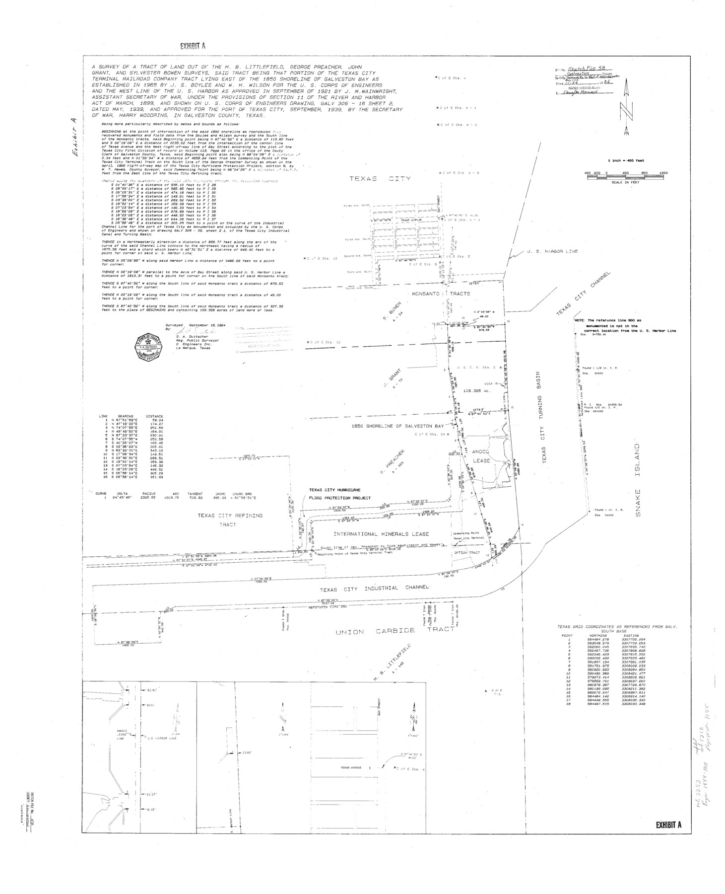
Galveston County Sketch File 58
Tx. City Terminal Ry. Co. East of 1850 Galveston Bay Line
-
Map/Doc
10458
-
Collection
General Map Collection
-
Object Dates
1984/9/18 (Creation Date)
1984/11/24 (File Date)
1984/9/18 (Survey Date)
-
People and Organizations
S.A. Duitscher (Surveyor/Engineer)
-
Counties
Galveston
-
Subjects
Surveying Sketch File
-
Height x Width
47.1 x 38.3 inches
119.6 x 97.3 cm
-
Medium
paper, print
-
Scale
1" = 400 feet
-
Features
Bay Street
Snake Island
Galveston Bay
Texas City Turning Basin
Texas City Channel
Fourth Avenue South
Third Avenue South
Second Avenue South
First Avenue South
Galveston Bay
First Street
Second Street
Third Street
Texas Avenue
First Avenue North
Bay Street
Texas City Industrial Canal and Turning Basin
Texas City
Part of: General Map Collection
Gaines County Sketch File 6

Print $20.00
- Digital $50.00
Gaines County Sketch File 6
1924
Size 20.9 x 21.3 inches
Map/Doc 11523
Nueces County Rolled Sketch 61

Print $20.00
- Digital $50.00
Nueces County Rolled Sketch 61
1977
Size 32.2 x 39.3 inches
Map/Doc 6907
Foard County Sketch File 35

Print $20.00
- Digital $50.00
Foard County Sketch File 35
Size 25.2 x 24.8 inches
Map/Doc 6067
Gonzales County Working Sketch 13

Print $2.00
- Digital $50.00
Gonzales County Working Sketch 13
1981
Size 12.5 x 7.6 inches
Map/Doc 63229
Crockett County Rolled Sketch 44

Print $20.00
- Digital $50.00
Crockett County Rolled Sketch 44
Size 44.5 x 36.8 inches
Map/Doc 76170
Galveston County NRC Article 33.136 Sketch 95

Print $40.00
Galveston County NRC Article 33.136 Sketch 95
2024
Map/Doc 97368
Chambers County Sketch File 15

Print $4.00
- Digital $50.00
Chambers County Sketch File 15
Size 8.3 x 12.4 inches
Map/Doc 17563
Flight Mission No. DCL-7C, Frame 67, Kenedy County

Print $20.00
- Digital $50.00
Flight Mission No. DCL-7C, Frame 67, Kenedy County
1943
Size 15.5 x 15.3 inches
Map/Doc 86053
Grayson County Working Sketch 15

Print $20.00
- Digital $50.00
Grayson County Working Sketch 15
1953
Size 24.8 x 20.6 inches
Map/Doc 63254
Flight Mission No. DQO-1K, Frame 148, Galveston County

Print $20.00
- Digital $50.00
Flight Mission No. DQO-1K, Frame 148, Galveston County
1952
Size 18.8 x 22.5 inches
Map/Doc 85001
Eastland County Working Sketch 10

Print $20.00
- Digital $50.00
Eastland County Working Sketch 10
1919
Size 20.2 x 16.3 inches
Map/Doc 68791
Refugio County Boundary File 2a

Print $8.00
- Digital $50.00
Refugio County Boundary File 2a
Size 14.5 x 9.1 inches
Map/Doc 58240
You may also like
Liberty County Working Sketch 87

Print $20.00
- Digital $50.00
Liberty County Working Sketch 87
1989
Size 37.4 x 32.5 inches
Map/Doc 70547
Bastrop County

Print $20.00
- Digital $50.00
Bastrop County
1879
Size 27.1 x 26.1 inches
Map/Doc 692
Bryan Walker Farm

Print $20.00
- Digital $50.00
Bryan Walker Farm
Size 17.1 x 15.5 inches
Map/Doc 92339
Jeff Davis County Sketch File 22

Print $20.00
- Digital $50.00
Jeff Davis County Sketch File 22
1923
Size 19.4 x 25.0 inches
Map/Doc 11860
Refugio County Boundary File 5

Print $4.00
- Digital $50.00
Refugio County Boundary File 5
Size 11.2 x 8.6 inches
Map/Doc 58256
Gregg County Rolled Sketch 26

Print $40.00
- Digital $50.00
Gregg County Rolled Sketch 26
1937
Size 25.8 x 129.0 inches
Map/Doc 9077
Randall County Rolled Sketch 9B

Print $20.00
- Digital $50.00
Randall County Rolled Sketch 9B
1985
Size 45.0 x 34.5 inches
Map/Doc 9810
Hardin County Sketch File XYZ

Print $4.00
- Digital $50.00
Hardin County Sketch File XYZ
1894
Size 11.3 x 8.7 inches
Map/Doc 25073
Cooke County Sketch File 10

Print $4.00
- Digital $50.00
Cooke County Sketch File 10
1855
Size 13.0 x 8.4 inches
Map/Doc 19242
Map of Prison Property in Walker County, Texas

Print $20.00
- Digital $50.00
Map of Prison Property in Walker County, Texas
Size 37.6 x 42.9 inches
Map/Doc 62993
Map of Bell County

Print $40.00
- Digital $50.00
Map of Bell County
1896
Size 48.1 x 54.4 inches
Map/Doc 82066
Concho County Sketch File 39

Print $8.00
- Digital $50.00
Concho County Sketch File 39
1949
Size 11.3 x 8.8 inches
Map/Doc 19190