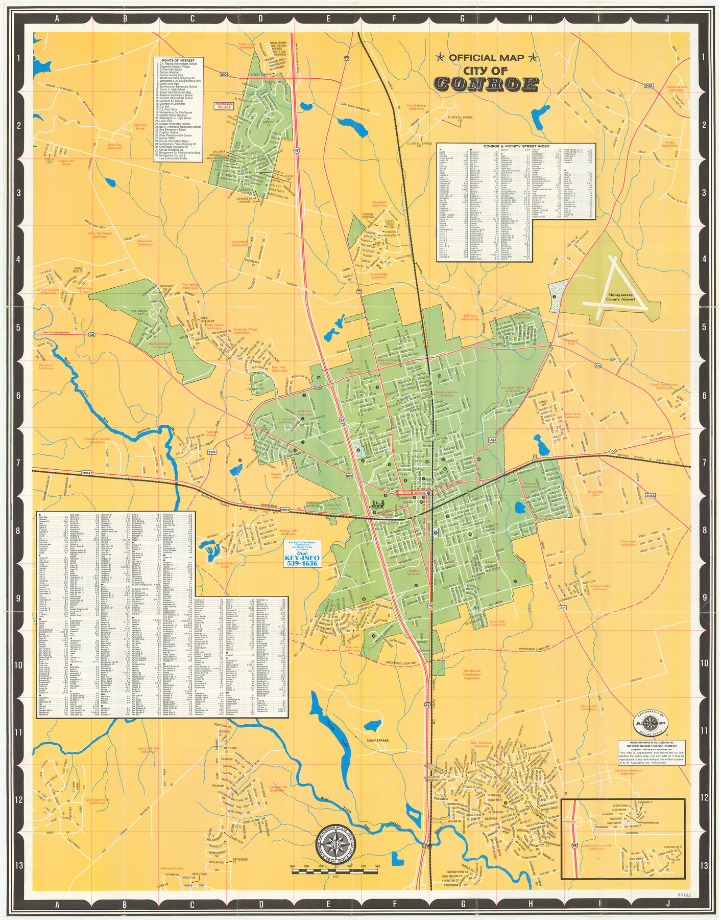
Conroe
[Verso - Official Map of Conroe]
-
Map/Doc
94366
-
Collection
General Map Collection
-
Object Dates
1985 (Copyright Date)
-
People and Organizations
A.I.D. Associates, Inc. (Publisher)
-
Counties
Montgomery
-
Subjects
City
-
Height x Width
27.7 x 21.7 inches
70.4 x 55.1 cm
-
Medium
paper, etching/engraving/lithograph
-
Comments
For map of Montgomery County on recto, see 94365. For research only.
Related maps

Part of: General Map Collection
Carte du Mexique et des Pays Limitrophes Situés au Nord et à l'Est

Print $20.00
- Digital $50.00
Carte du Mexique et des Pays Limitrophes Situés au Nord et à l'Est
1811
Size 17.5 x 29.0 inches
Map/Doc 93421
Upshur County Sketch File 13

Print $4.00
- Digital $50.00
Upshur County Sketch File 13
1861
Size 8.2 x 8.3 inches
Map/Doc 38755
Brewster County Rolled Sketch 97

Print $20.00
- Digital $50.00
Brewster County Rolled Sketch 97
1952
Size 31.6 x 30.7 inches
Map/Doc 5254
Map and Profile of the Denison and Pacific Railway from Denison to Whitesboro

Print $40.00
- Digital $50.00
Map and Profile of the Denison and Pacific Railway from Denison to Whitesboro
1878
Size 42.5 x 57.5 inches
Map/Doc 64284
Sutton County Working Sketch 49

Print $20.00
- Digital $50.00
Sutton County Working Sketch 49
1955
Size 43.3 x 19.5 inches
Map/Doc 62392
Kendall County

Print $20.00
- Digital $50.00
Kendall County
1946
Size 42.5 x 36.8 inches
Map/Doc 95553
Bell County Working Sketch 10

Print $20.00
- Digital $50.00
Bell County Working Sketch 10
1954
Size 38.2 x 41.4 inches
Map/Doc 67350
Flight Mission No. BRE-2P, Frame 111, Nueces County

Print $20.00
- Digital $50.00
Flight Mission No. BRE-2P, Frame 111, Nueces County
1956
Size 18.4 x 22.6 inches
Map/Doc 86797
Flight Mission No. DIX-8P, Frame 83, Aransas County

Print $20.00
- Digital $50.00
Flight Mission No. DIX-8P, Frame 83, Aransas County
1956
Size 18.6 x 22.3 inches
Map/Doc 83908
Anderson County Working Sketch 44

Print $20.00
- Digital $50.00
Anderson County Working Sketch 44
1991
Size 27.7 x 32.3 inches
Map/Doc 67044

Orange County NRC Article 33.136 Sketch 2

Print $9.00
- Digital $50.00
Orange County NRC Article 33.136 Sketch 2
2011
Size 9.7 x 15.5 inches
Map/Doc 93263
You may also like
Right of Way & Track Map, St. Louis, Brownsville & Mexico Ry. operated by St. Louis, Brownsville & Mexico Ry. Co.

Print $40.00
- Digital $50.00
Right of Way & Track Map, St. Louis, Brownsville & Mexico Ry. operated by St. Louis, Brownsville & Mexico Ry. Co.
1919
Size 25.5 x 57.0 inches
Map/Doc 64626
Newton County Working Sketch 17

Print $20.00
- Digital $50.00
Newton County Working Sketch 17
1950
Size 15.1 x 23.0 inches
Map/Doc 71263
Young County Rolled Sketch 14

Print $20.00
- Digital $50.00
Young County Rolled Sketch 14
1967
Size 17.7 x 22.7 inches
Map/Doc 8302
[River Secs. 68-73, Archer County School Land League 3 and surrounding surveys]
![90468, [River Secs. 68-73, Archer County School Land League 3 and surrounding surveys], Twichell Survey Records](https://historictexasmaps.com/wmedia_w700/maps/90468-1.tif.jpg)
Print $20.00
- Digital $50.00
[River Secs. 68-73, Archer County School Land League 3 and surrounding surveys]
Size 38.4 x 36.4 inches
Map/Doc 90468
Flight Mission No. DCL-6C, Frame 120, Kenedy County

Print $20.00
- Digital $50.00
Flight Mission No. DCL-6C, Frame 120, Kenedy County
1943
Size 18.4 x 22.3 inches
Map/Doc 85950
Presidio County Sketch File 49

Print $6.00
- Digital $50.00
Presidio County Sketch File 49
1919
Size 14.6 x 11.9 inches
Map/Doc 34584
Jones County Working Sketch 4

Print $20.00
- Digital $50.00
Jones County Working Sketch 4
1946
Size 35.5 x 20.6 inches
Map/Doc 66642
[Block 47, Sections 17- 29]
![91176, [Block 47, Sections 17- 29], Twichell Survey Records](https://historictexasmaps.com/wmedia_w700/maps/91176-1.tif.jpg)
Print $20.00
- Digital $50.00
[Block 47, Sections 17- 29]
Size 25.2 x 18.4 inches
Map/Doc 91176
Atascosa County Working Sketch 21

Print $20.00
- Digital $50.00
Atascosa County Working Sketch 21
1954
Size 26.0 x 22.4 inches
Map/Doc 67217
Eastland County Working Sketch 27

Print $20.00
- Digital $50.00
Eastland County Working Sketch 27
1952
Size 25.2 x 21.4 inches
Map/Doc 68808
Flight Mission No. CLL-1N, Frame 190, Willacy County

Print $20.00
- Digital $50.00
Flight Mission No. CLL-1N, Frame 190, Willacy County
1954
Size 18.5 x 22.2 inches
Map/Doc 87060
Little River, Faubion Bridge Sheet

Print $20.00
- Digital $50.00
Little River, Faubion Bridge Sheet
1914
Size 18.5 x 27.6 inches
Map/Doc 69682