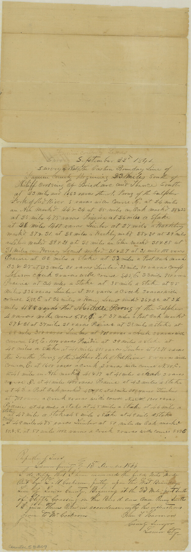
Fannin County Boundary File 5
County Boundaries - Fannin and Lamar Cos.
-
Map/Doc
53309
-
Collection
General Map Collection
-
Counties
Fannin
-
Subjects
County Boundaries
-
Height x Width
22.3 x 7.7 inches
56.6 x 19.6 cm
Part of: General Map Collection
Cooke County Sketch File 9

Print $6.00
- Digital $50.00
Cooke County Sketch File 9
Size 8.2 x 10.5 inches
Map/Doc 19237
Val Verde County Working Sketch 27

Print $20.00
- Digital $50.00
Val Verde County Working Sketch 27
1937
Size 26.6 x 26.4 inches
Map/Doc 72162
Amistad International Reservoir on Rio Grande 96

Print $20.00
- Digital $50.00
Amistad International Reservoir on Rio Grande 96
1950
Size 28.5 x 41.0 inches
Map/Doc 75527
Reeves County Working Sketch 39

Print $40.00
- Digital $50.00
Reeves County Working Sketch 39
1971
Size 60.9 x 36.2 inches
Map/Doc 63482
Pecos County Rolled Sketch 177

Print $20.00
- Digital $50.00
Pecos County Rolled Sketch 177
1972
Size 27.4 x 38.0 inches
Map/Doc 7297
Orange County Working Sketch 39

Print $20.00
- Digital $50.00
Orange County Working Sketch 39
1966
Size 20.5 x 27.8 inches
Map/Doc 71371
Tyler County Sketch File 25

Print $28.00
- Digital $50.00
Tyler County Sketch File 25
1953
Size 14.5 x 9.0 inches
Map/Doc 38689
Flight Mission No. CRC-3R, Frame 100, Chambers County

Print $20.00
- Digital $50.00
Flight Mission No. CRC-3R, Frame 100, Chambers County
1956
Size 18.6 x 22.3 inches
Map/Doc 84838
Potter County Working Sketch 7

Print $20.00
- Digital $50.00
Potter County Working Sketch 7
1960
Size 18.4 x 37.4 inches
Map/Doc 71667
[Surveys near Quihi Creek]
![312, [Surveys near Quihi Creek], General Map Collection](https://historictexasmaps.com/wmedia_w700/maps/312.tif.jpg)
Print $2.00
- Digital $50.00
[Surveys near Quihi Creek]
1846
Size 11.0 x 8.0 inches
Map/Doc 312
Edwards County Sketch File ECS

Print $6.00
- Digital $50.00
Edwards County Sketch File ECS
1937
Size 11.5 x 8.8 inches
Map/Doc 21774
Preliminary map of Brazos Island

Print $20.00
- Digital $50.00
Preliminary map of Brazos Island
1863
Size 25.2 x 18.1 inches
Map/Doc 72924
You may also like
Map showing the fortification at Point Isabel

Print $20.00
- Digital $50.00
Map showing the fortification at Point Isabel
1864
Size 18.3 x 27.9 inches
Map/Doc 72921
Presidio County Rolled Sketch 131A

Print $20.00
- Digital $50.00
Presidio County Rolled Sketch 131A
Size 47.5 x 36.6 inches
Map/Doc 10711
Garza County Working Sketch 12

Print $20.00
- Digital $50.00
Garza County Working Sketch 12
1956
Size 31.9 x 24.4 inches
Map/Doc 63159
Webb County Rolled Sketch 46

Print $20.00
- Digital $50.00
Webb County Rolled Sketch 46
1942
Size 25.8 x 27.6 inches
Map/Doc 8202
Cameron County NRC Article 33.136 Sketch 1

Print $3.00
- Digital $50.00
Cameron County NRC Article 33.136 Sketch 1
2001
Size 11.3 x 17.4 inches
Map/Doc 61558
Hardeman County Boundary File 3a

Print $42.00
- Digital $50.00
Hardeman County Boundary File 3a
Size 56.8 x 12.3 inches
Map/Doc 54384
Medina County Sketch File 11

Print $14.00
- Digital $50.00
Medina County Sketch File 11
1907
Size 10.4 x 6.6 inches
Map/Doc 31461
The Republic County of Washington. December 29, 1845

Print $20.00
The Republic County of Washington. December 29, 1845
2020
Size 11.8 x 21.7 inches
Map/Doc 96310
General Highway Map, Lamb County, Texas

Print $20.00
General Highway Map, Lamb County, Texas
1940
Size 24.7 x 18.3 inches
Map/Doc 79168
Loving County Working Sketch 24

Print $40.00
- Digital $50.00
Loving County Working Sketch 24
1952
Size 15.8 x 63.3 inches
Map/Doc 70658
Grayson County Boundary File 4a

Print $24.00
- Digital $50.00
Grayson County Boundary File 4a
Size 10.0 x 42.7 inches
Map/Doc 53956
Orange County Working Sketch 2

Print $20.00
- Digital $50.00
Orange County Working Sketch 2
1917
Size 12.8 x 13.1 inches
Map/Doc 71334