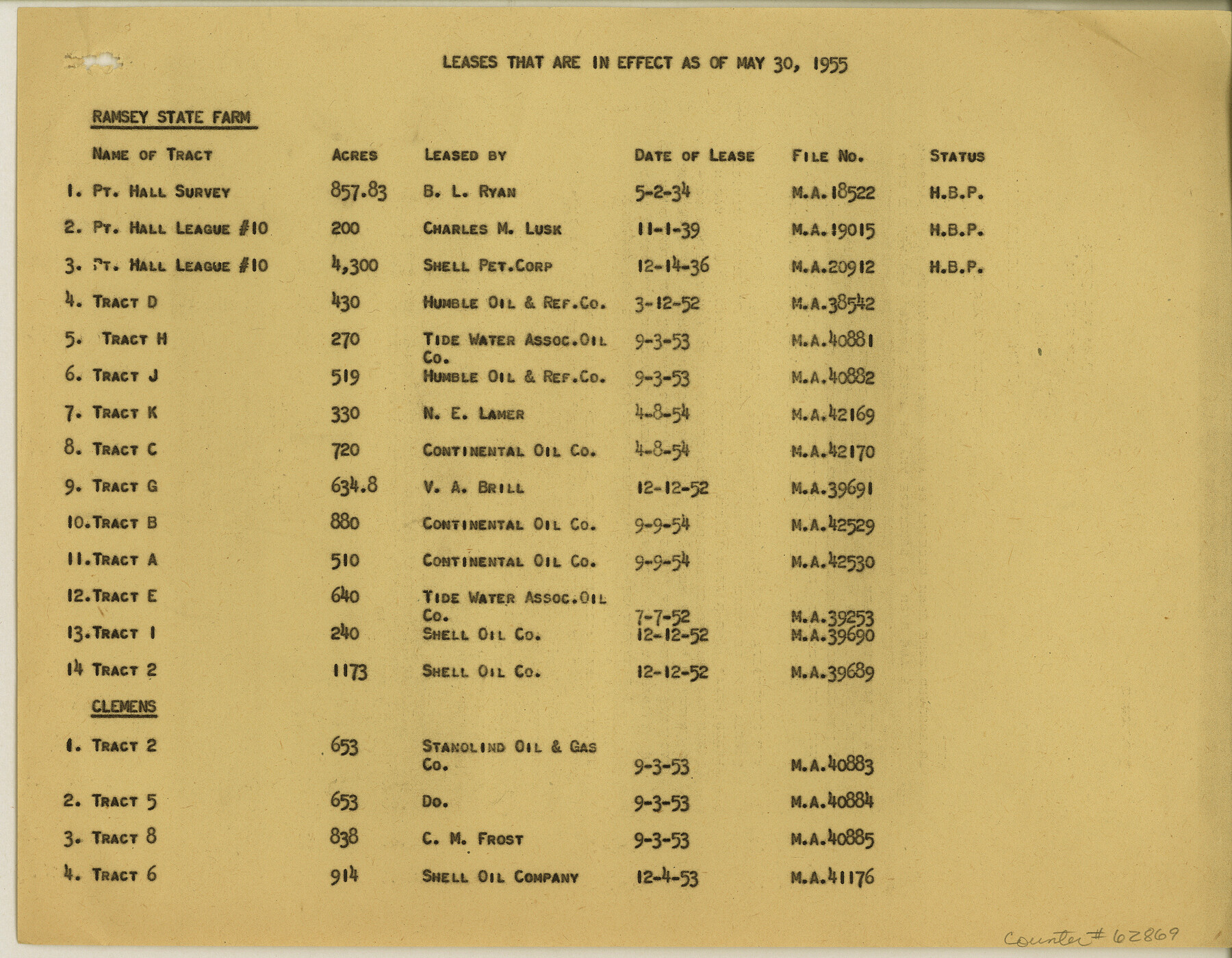
Maps & Lists Showing Prison Lands (Oil & Gas) Leased as of June 1955
K-7-82
-
Map/Doc
62869
-
Collection
General Map Collection
-
Counties
Brazoria
-
Height x Width
8.7 x 11.2 inches
22.1 x 28.4 cm
Part of: General Map Collection
Duval County Working Sketch 5
Print $40.00
- Digital $50.00
Duval County Working Sketch 5
1933
Size 43.2 x 54.2 inches
Map/Doc 68718
Gaines County Rolled Sketch 29

Print $20.00
- Digital $50.00
Gaines County Rolled Sketch 29
1990
Size 14.7 x 20.5 inches
Map/Doc 5942
La Salle County Working Sketch 20

Print $20.00
- Digital $50.00
La Salle County Working Sketch 20
1941
Size 23.7 x 29.9 inches
Map/Doc 70321
Aransas County NRC Article 33.136 Sketch 17

Print $206.00
- Digital $50.00
Aransas County NRC Article 33.136 Sketch 17
2019
Size 22.4 x 35.8 inches
Map/Doc 96475
Matagorda Light to Aransas Pass

Print $20.00
- Digital $50.00
Matagorda Light to Aransas Pass
1988
Size 35.2 x 44.3 inches
Map/Doc 73404
Nueces County Rolled Sketch 129 A-C

Print $6.00
- Digital $50.00
Nueces County Rolled Sketch 129 A-C
1998
Size 11.2 x 8.8 inches
Map/Doc 41616
DeWitt County Sketch File 1

Print $11.00
- Digital $50.00
DeWitt County Sketch File 1
1851
Size 8.4 x 8.2 inches
Map/Doc 20794
Flight Mission No. DIX-8P, Frame 68, Aransas County

Print $20.00
- Digital $50.00
Flight Mission No. DIX-8P, Frame 68, Aransas County
1956
Size 18.7 x 22.5 inches
Map/Doc 83899
Brewster County Sketch File FN-35

Print $8.00
- Digital $50.00
Brewster County Sketch File FN-35
1979
Size 14.2 x 8.9 inches
Map/Doc 15861
Flight Mission No. CRC-3R, Frame 27, Chambers County

Print $20.00
- Digital $50.00
Flight Mission No. CRC-3R, Frame 27, Chambers County
1956
Size 18.7 x 22.3 inches
Map/Doc 84801
Crockett County Rolled Sketch 53

Print $20.00
- Digital $50.00
Crockett County Rolled Sketch 53
1942
Size 17.5 x 36.8 inches
Map/Doc 5598
Hardin County Sketch File 71f

Print $20.00
- Digital $50.00
Hardin County Sketch File 71f
1997
Size 25.2 x 36.7 inches
Map/Doc 11643
You may also like
Panola County Working Sketch 26

Print $20.00
- Digital $50.00
Panola County Working Sketch 26
1958
Map/Doc 71435
Newton County Rolled Sketch 6A

Digital $50.00
Newton County Rolled Sketch 6A
Size 10.3 x 15.4 inches
Map/Doc 46838
[Maps of surveys in Reeves & Culberson Cos]
![61131, [Maps of surveys in Reeves & Culberson Cos], General Map Collection](https://historictexasmaps.com/wmedia_w700/maps/61131.tif.jpg)
Print $20.00
- Digital $50.00
[Maps of surveys in Reeves & Culberson Cos]
1937
Size 30.6 x 24.8 inches
Map/Doc 61131
Hardeman County Boundary File 4

Print $142.00
- Digital $50.00
Hardeman County Boundary File 4
Size 24.0 x 18.2 inches
Map/Doc 54392
[Part of Block GG]
![90314, [Part of Block GG], Twichell Survey Records](https://historictexasmaps.com/wmedia_w700/maps/90314-1.tif.jpg)
Print $20.00
- Digital $50.00
[Part of Block GG]
Size 15.2 x 21.5 inches
Map/Doc 90314
Washington County Working Sketch 1

Print $20.00
- Digital $50.00
Washington County Working Sketch 1
1957
Size 25.1 x 25.4 inches
Map/Doc 72362
Jefferson County Sketch File 28

Print $2.00
- Digital $50.00
Jefferson County Sketch File 28
1900
Size 9.2 x 8.6 inches
Map/Doc 28193
Dimmit County Working Sketch 23

Print $20.00
- Digital $50.00
Dimmit County Working Sketch 23
1954
Size 22.5 x 23.3 inches
Map/Doc 68684
Flight Mission No. CRE-1R, Frame 195, Jackson County

Print $20.00
- Digital $50.00
Flight Mission No. CRE-1R, Frame 195, Jackson County
1956
Size 18.6 x 22.3 inches
Map/Doc 85349
[Blocks C-25, C-26, C-27, and 29]
![91320, [Blocks C-25, C-26, C-27, and 29], Twichell Survey Records](https://historictexasmaps.com/wmedia_w700/maps/91320-1.tif.jpg)
Print $20.00
- Digital $50.00
[Blocks C-25, C-26, C-27, and 29]
Size 23.4 x 27.2 inches
Map/Doc 91320
Refugio County Boundary File 3a

Print $28.00
- Digital $50.00
Refugio County Boundary File 3a
Size 14.1 x 8.8 inches
Map/Doc 58246
General Highway Map, Presidio County, Texas

Print $20.00
General Highway Map, Presidio County, Texas
1940
Size 24.6 x 18.3 inches
Map/Doc 79222