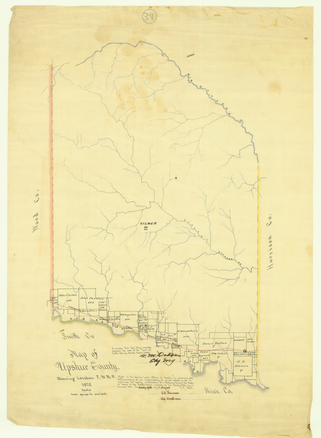
Map of Upshur County Showing Location T&P R.
Z-2-34
-
Map/Doc
64137
-
Collection
General Map Collection
-
Object Dates
1872 (Creation Date)
1872/8/28 (File Date)
-
People and Organizations
G.M. Dodge (Surveyor/Engineer)
C. C. Stremme (Draftsman)
-
Counties
Upshur
-
Subjects
Railroads
-
Height x Width
26.5 x 19.4 inches
67.3 x 49.3 cm
-
Medium
linen, manuscript
-
Scale
1" = 4000 varas
-
Comments
Adopted and conservation funded in 2006 by Dick and Cathy Roberts, Quitman, Texas.
See 64134 through 64139 for all sheets of this map. -
Features
T&P
Sabine River
Longview
Little Cypress Creek
Gilmer
Big Cypress Creek
Part of: General Map Collection
Rusk County Rolled Sketch 8

Print $20.00
- Digital $50.00
Rusk County Rolled Sketch 8
1959
Size 22.6 x 26.3 inches
Map/Doc 7544
Aransas County Rolled Sketch 31A

Print $20.00
- Digital $50.00
Aransas County Rolled Sketch 31A
1950
Size 25.1 x 42.4 inches
Map/Doc 77499
Flight Mission No. DIX-8P, Frame 87, Aransas County

Print $20.00
- Digital $50.00
Flight Mission No. DIX-8P, Frame 87, Aransas County
1956
Size 16.4 x 19.0 inches
Map/Doc 83912
Ward County Working Sketch 5

Print $20.00
- Digital $50.00
Ward County Working Sketch 5
1943
Size 19.1 x 36.5 inches
Map/Doc 72311
Erath County Working Sketch 26

Print $20.00
- Digital $50.00
Erath County Working Sketch 26
1969
Size 20.8 x 15.0 inches
Map/Doc 69107
Madison County Working Sketch 8

Print $20.00
- Digital $50.00
Madison County Working Sketch 8
1982
Size 22.4 x 28.8 inches
Map/Doc 70770
Culberson County Working Sketch 3

Print $40.00
- Digital $50.00
Culberson County Working Sketch 3
Size 50.6 x 21.1 inches
Map/Doc 68455
Parmer County Sketch File 4

Print $44.00
- Digital $50.00
Parmer County Sketch File 4
1913
Size 7.1 x 8.6 inches
Map/Doc 33630
Ward County Working Sketch 35

Print $20.00
- Digital $50.00
Ward County Working Sketch 35
1968
Size 46.4 x 43.0 inches
Map/Doc 72341
Liberty County Working Sketch 17

Print $20.00
- Digital $50.00
Liberty County Working Sketch 17
1934
Size 34.5 x 24.0 inches
Map/Doc 70476
Stonewall County

Print $40.00
- Digital $50.00
Stonewall County
1933
Size 48.0 x 39.4 inches
Map/Doc 95646
Maverick County Sketch File 1 1/2

Print $20.00
- Digital $50.00
Maverick County Sketch File 1 1/2
1875
Size 23.2 x 27.6 inches
Map/Doc 12049
You may also like
Upshur County Sketch File 2a

Print $4.00
- Digital $50.00
Upshur County Sketch File 2a
Size 12.9 x 8.2 inches
Map/Doc 38734
Gulf of Mexico

Print $20.00
- Digital $50.00
Gulf of Mexico
1908
Size 18.3 x 26.9 inches
Map/Doc 72655
Medina County Rolled Sketch 17

Print $20.00
- Digital $50.00
Medina County Rolled Sketch 17
1979
Size 32.3 x 18.9 inches
Map/Doc 6750
Moore County Rolled Sketch 13
Print $20.00
- Digital $50.00
Moore County Rolled Sketch 13
1920
Size 25.8 x 33.3 inches
Map/Doc 6829
Flight Mission No. DQN-2K, Frame 137, Calhoun County

Print $20.00
- Digital $50.00
Flight Mission No. DQN-2K, Frame 137, Calhoun County
1953
Size 18.8 x 22.5 inches
Map/Doc 84306
[Bastrop District]
![83005, [Bastrop District], General Map Collection](https://historictexasmaps.com/wmedia_w700/maps/83005.tif.jpg)
Print $40.00
- Digital $50.00
[Bastrop District]
1895
Size 37.4 x 51.9 inches
Map/Doc 83005
Map of part of Presidio Co. Texas

Print $20.00
- Digital $50.00
Map of part of Presidio Co. Texas
Size 16.5 x 21.3 inches
Map/Doc 75769
Ector County Working Sketch 18

Print $20.00
- Digital $50.00
Ector County Working Sketch 18
1957
Size 42.0 x 39.1 inches
Map/Doc 68861
Brewster County Sketch File N-3b

Print $4.00
- Digital $50.00
Brewster County Sketch File N-3b
Size 12.7 x 8.4 inches
Map/Doc 15592
Map of Burleson County

Print $20.00
- Digital $50.00
Map of Burleson County
1867
Size 19.1 x 30.0 inches
Map/Doc 4511
Refugio County Working Sketch 4

Print $20.00
- Digital $50.00
Refugio County Working Sketch 4
1937
Size 33.2 x 31.4 inches
Map/Doc 63513
Pecos County Sketch File 76

Print $4.00
- Digital $50.00
Pecos County Sketch File 76
1943
Size 11.2 x 8.8 inches
Map/Doc 33907