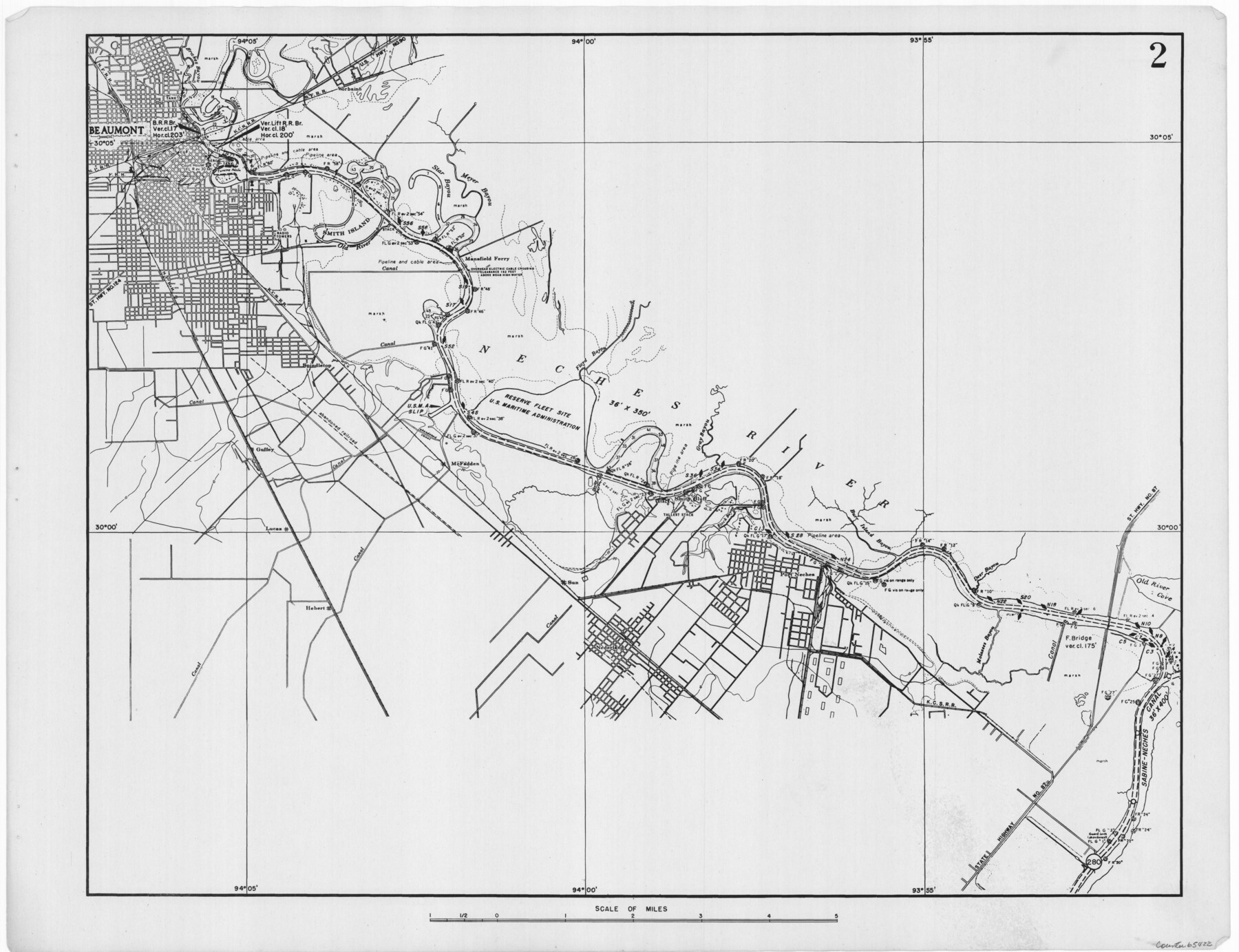
Navigation Maps of Gulf Intracoastal Waterway, Port Arthur to Brownsville, Texas
K-7-68
-
Map/Doc
65422
-
Collection
General Map Collection
-
Object Dates
1951 (Creation Date)
-
People and Organizations
Corps of Engineers (Publisher)
-
Counties
Jefferson
-
Subjects
Intracoastal Waterways
-
Height x Width
16.6 x 21.6 inches
42.2 x 54.9 cm
Part of: General Map Collection
Hunt County Sketch File 9

Print $3.00
- Digital $50.00
Hunt County Sketch File 9
1851
Size 10.0 x 14.8 inches
Map/Doc 27099
Flight Mission No. BRA-7M, Frame 81, Jefferson County

Print $20.00
- Digital $50.00
Flight Mission No. BRA-7M, Frame 81, Jefferson County
1953
Size 16.0 x 15.8 inches
Map/Doc 85503
Kenedy County Sketch File 3

Print $22.00
- Digital $50.00
Kenedy County Sketch File 3
2003
Size 11.0 x 8.5 inches
Map/Doc 82452
Tom Green County Sketch File 84

Print $20.00
- Digital $50.00
Tom Green County Sketch File 84
1890
Size 20.6 x 18.5 inches
Map/Doc 12456
Wharton County Working Sketch 14

Print $20.00
- Digital $50.00
Wharton County Working Sketch 14
1961
Size 26.5 x 24.9 inches
Map/Doc 72478
Gregg County Rolled Sketch 9

Print $20.00
- Digital $50.00
Gregg County Rolled Sketch 9
1933
Size 38.0 x 29.8 inches
Map/Doc 6034
Johnson County Working Sketch 31

Print $20.00
- Digital $50.00
Johnson County Working Sketch 31
2007
Size 21.2 x 22.0 inches
Map/Doc 87499

Bee County Working Sketch 33

Print $20.00
- Digital $50.00
Bee County Working Sketch 33
1980
Size 32.0 x 28.2 inches
Map/Doc 67284
Concho County Boundary File 2

Print $30.00
- Digital $50.00
Concho County Boundary File 2
Size 12.7 x 8.3 inches
Map/Doc 51814
Map of Texas and Pacific Ry. Company's Surveys in the 80 Mile Reserve

Print $40.00
- Digital $50.00
Map of Texas and Pacific Ry. Company's Surveys in the 80 Mile Reserve
1885
Size 41.5 x 91.8 inches
Map/Doc 60313
Jones County Rolled Sketch 2

Print $40.00
- Digital $50.00
Jones County Rolled Sketch 2
2009
Size 48.0 x 34.0 inches
Map/Doc 93320
You may also like
Brown County Sketch File 21

Print $40.00
- Digital $50.00
Brown County Sketch File 21
Size 16.4 x 12.8 inches
Map/Doc 11021
Zavala County Rolled Sketch 18

Print $20.00
- Digital $50.00
Zavala County Rolled Sketch 18
Size 39.4 x 27.3 inches
Map/Doc 8322
Presidio County Working Sketch 29

Print $20.00
- Digital $50.00
Presidio County Working Sketch 29
1946
Size 40.0 x 36.6 inches
Map/Doc 71705


[Sketch Showing Connections Between Blocks X, RG, and A]
![91375, [Sketch Showing Connections Between Blocks X, RG, and A], Twichell Survey Records](https://historictexasmaps.com/wmedia_w700/maps/91375-1.tif.jpg)
Print $20.00
- Digital $50.00
[Sketch Showing Connections Between Blocks X, RG, and A]
Size 17.5 x 26.0 inches
Map/Doc 91375
Topographical Map of the Rio Grande, Sheet No. 25

Print $20.00
- Digital $50.00
Topographical Map of the Rio Grande, Sheet No. 25
1912
Map/Doc 89549
Tarrant County Sketch File 31

Print $20.00
- Digital $50.00
Tarrant County Sketch File 31
Size 27.2 x 39.3 inches
Map/Doc 10380
Hopkins County Sketch File 2

Print $28.00
- Digital $50.00
Hopkins County Sketch File 2
1845
Size 11.1 x 7.9 inches
Map/Doc 26678
Val Verde County Working Sketch 23

Print $20.00
- Digital $50.00
Val Verde County Working Sketch 23
1932
Size 29.6 x 24.9 inches
Map/Doc 72158
General Land Office and State Reclamation Department - An Index Map

Print $20.00
- Digital $50.00
General Land Office and State Reclamation Department - An Index Map
1930
Size 26.2 x 16.6 inches
Map/Doc 65069
San Augustine County Working Sketch 10

Print $20.00
- Digital $50.00
San Augustine County Working Sketch 10
1935
Size 35.0 x 32.2 inches
Map/Doc 63697