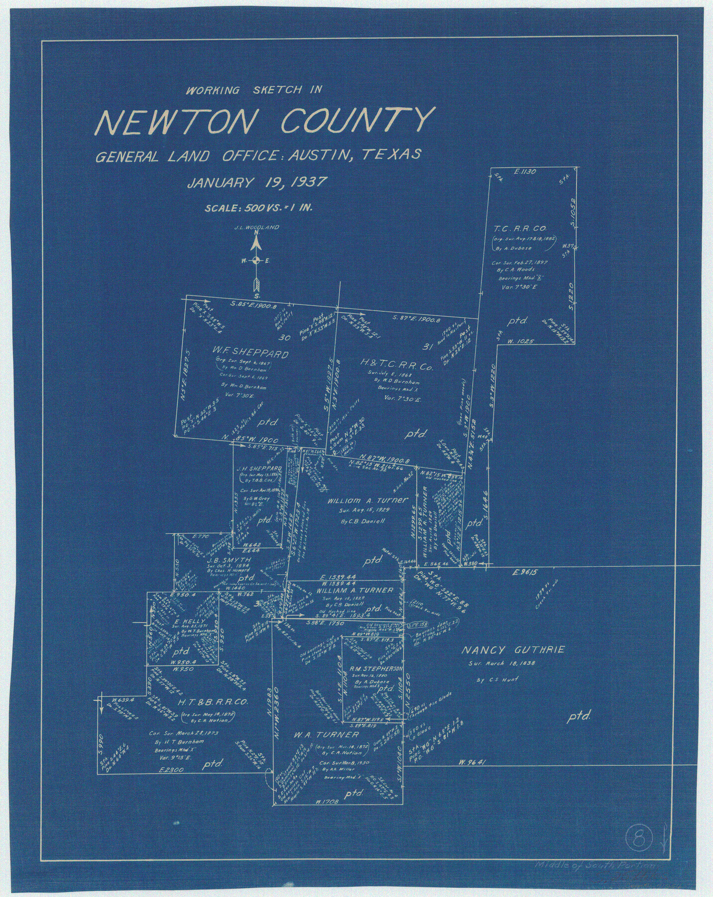
Newton County Working Sketch 8
-
Map/Doc
71254
-
Collection
General Map Collection
-
Object Dates
1/19/1937 (Creation Date)
-
People and Organizations
J.L. Woodland (Draftsman)
-
Counties
Newton
-
Subjects
Surveying Working Sketch
-
Height x Width
23.2 x 18.5 inches
58.9 x 47.0 cm
-
Scale
1" = 500 varas
Part of: General Map Collection
Kinney County Sketch File E1

Print $20.00
- Digital $50.00
Kinney County Sketch File E1
1885
Size 29.8 x 31.9 inches
Map/Doc 10619
Hopkins County

Print $20.00
- Digital $50.00
Hopkins County
1942
Size 44.1 x 40.9 inches
Map/Doc 73183
Orange County Rolled Sketch 27

Print $20.00
- Digital $50.00
Orange County Rolled Sketch 27
1954
Size 22.3 x 34.5 inches
Map/Doc 7186
Lubbock County Boundary File 10

Print $108.00
- Digital $50.00
Lubbock County Boundary File 10
Size 14.3 x 8.7 inches
Map/Doc 56549
Brazoria County Sketch File 13

Print $40.00
- Digital $50.00
Brazoria County Sketch File 13
Size 23.8 x 23.0 inches
Map/Doc 10950
Lavaca County Rolled Sketch 6

Print $20.00
- Digital $50.00
Lavaca County Rolled Sketch 6
1986
Size 44.8 x 33.9 inches
Map/Doc 10290
Right of Way and Track Map, Galveston, Harrisburg & San Antonio Ry. operated by the T. & N. O. R.R. Co., Victoria Division, Rosenberg to Beeville

Print $40.00
- Digital $50.00
Right of Way and Track Map, Galveston, Harrisburg & San Antonio Ry. operated by the T. & N. O. R.R. Co., Victoria Division, Rosenberg to Beeville
1918
Size 24.8 x 57.1 inches
Map/Doc 76159
[Northern Bexar District]
![1963, [Northern Bexar District], General Map Collection](https://historictexasmaps.com/wmedia_w700/maps/1963-1.tif.jpg)
Print $20.00
- Digital $50.00
[Northern Bexar District]
1852
Size 46.0 x 26.5 inches
Map/Doc 1963
Crosby County Rolled Sketch R

Print $20.00
- Digital $50.00
Crosby County Rolled Sketch R
1926
Size 41.2 x 40.0 inches
Map/Doc 8740
Presidio County Sketch File G

Print $6.00
- Digital $50.00
Presidio County Sketch File G
1913
Size 9.7 x 17.0 inches
Map/Doc 34429
Rains County Working Sketch 6

Print $20.00
- Digital $50.00
Rains County Working Sketch 6
1958
Size 26.4 x 42.3 inches
Map/Doc 71832
McMullen County Working Sketch 10

Print $20.00
- Digital $50.00
McMullen County Working Sketch 10
1938
Size 21.6 x 22.8 inches
Map/Doc 70711
You may also like
Territory of New Mexico

Print $20.00
- Digital $50.00
Territory of New Mexico
1903
Size 23.8 x 19.6 inches
Map/Doc 82011
Flight Mission No. CGI-4N, Frame 172, Cameron County

Print $20.00
- Digital $50.00
Flight Mission No. CGI-4N, Frame 172, Cameron County
1955
Size 18.5 x 22.3 inches
Map/Doc 84675
Jim Hogg County Rolled Sketch 6

Print $40.00
- Digital $50.00
Jim Hogg County Rolled Sketch 6
1943
Size 51.9 x 38.4 inches
Map/Doc 9322
Hall County Sketch File 7

Print $20.00
- Digital $50.00
Hall County Sketch File 7
1890
Size 12.0 x 22.4 inches
Map/Doc 11603

United States

Print $40.00
- Digital $50.00
United States
1961
Size 55.0 x 81.2 inches
Map/Doc 75922
Montague County Working Sketch 25

Print $20.00
- Digital $50.00
Montague County Working Sketch 25
1955
Size 42.4 x 28.4 inches
Map/Doc 71091
Morris County Rolled Sketch 2A

Print $20.00
- Digital $50.00
Morris County Rolled Sketch 2A
Size 34.7 x 24.7 inches
Map/Doc 10229
Wilbarger County Boundary File 1c

Print $6.00
- Digital $50.00
Wilbarger County Boundary File 1c
Size 12.2 x 9.6 inches
Map/Doc 59954
Red River County Working Sketch Graphic Index, Sheet 2 (Sketches 49 to Most Recent)

Print $20.00
- Digital $50.00
Red River County Working Sketch Graphic Index, Sheet 2 (Sketches 49 to Most Recent)
1934
Size 46.4 x 39.1 inches
Map/Doc 76681
Brewster County Rolled Sketch 69

Print $20.00
- Digital $50.00
Brewster County Rolled Sketch 69
1940
Size 17.0 x 15.7 inches
Map/Doc 5235
Lee County Working Sketch 4

Print $20.00
- Digital $50.00
Lee County Working Sketch 4
1973
Size 17.1 x 18.4 inches
Map/Doc 70383