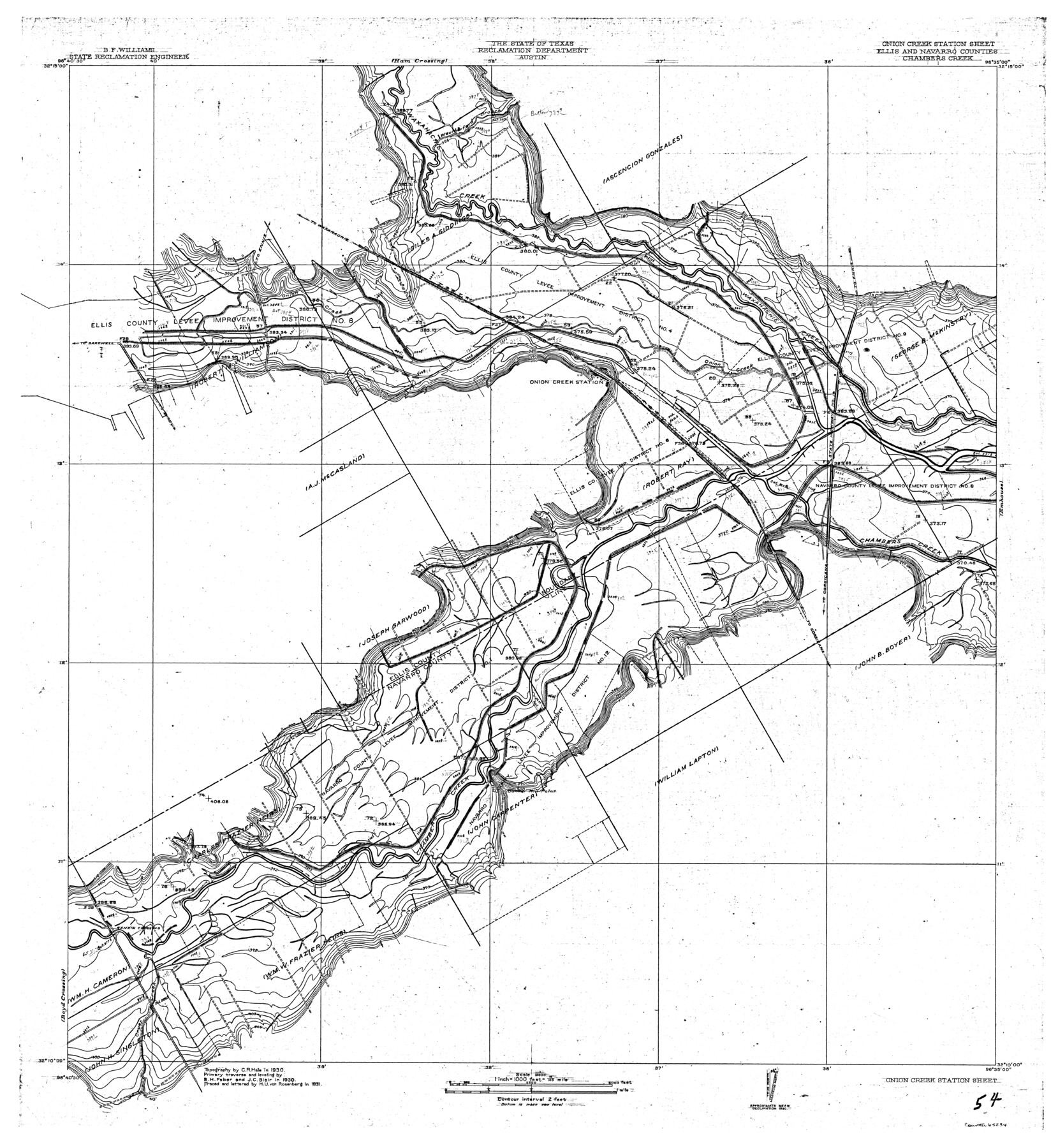
Trinity River, Onion Creek Station Sheet/Chambers Creek
-
Map/Doc
65234
-
Collection
General Map Collection
-
Object Dates
1931 (Creation Date)
-
People and Organizations
Texas State Reclamation Department (Publisher)
Curtis R. Hale (Surveyor/Engineer)
J.C. Blair (Surveyor/Engineer)
B.H. Faber (Surveyor/Engineer)
H.U. von Rosenberg (Compiler)
H.U. von Rosenberg (Draftsman)
-
Counties
Ellis Navarro
-
Subjects
River Surveys Topographic
-
Height x Width
35.1 x 32.4 inches
89.2 x 82.3 cm
-
Comments
Onion Creek Station Sheet located south of the Ham Crossing Sheet and west of the Emhouse Sheet.
Part of: General Map Collection
Map of Wilson County

Print $20.00
- Digital $50.00
Map of Wilson County
1879
Size 23.0 x 24.4 inches
Map/Doc 4157
Culberson Co.

Print $40.00
- Digital $50.00
Culberson Co.
1908
Size 49.0 x 32.9 inches
Map/Doc 66796
Collingsworth County

Print $20.00
- Digital $50.00
Collingsworth County
1899
Size 42.7 x 39.7 inches
Map/Doc 4915
Amistad International Reservoir on Rio Grande 90

Print $20.00
- Digital $50.00
Amistad International Reservoir on Rio Grande 90
1950
Size 28.5 x 39.7 inches
Map/Doc 75520
Duval County Rolled Sketch 33B

Digital $50.00
Duval County Rolled Sketch 33B
Size 42.5 x 76.2 inches
Map/Doc 8819
Midland County Boundary File 4b

Print $18.00
- Digital $50.00
Midland County Boundary File 4b
Size 13.6 x 9.0 inches
Map/Doc 57186
Kleberg County Rolled Sketch 10-41

Print $20.00
- Digital $50.00
Kleberg County Rolled Sketch 10-41
1952
Size 41.2 x 32.7 inches
Map/Doc 9385
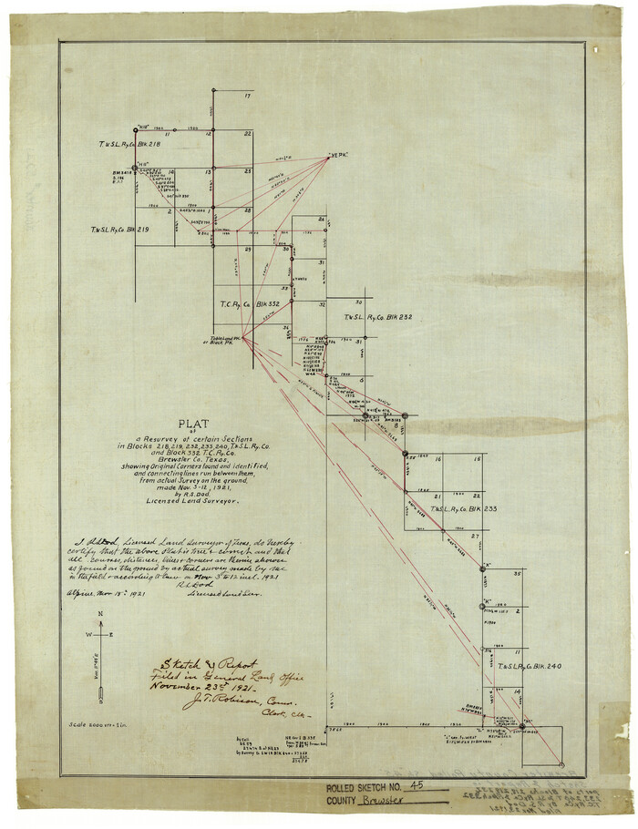
Brewster County Rolled Sketch 74

Print $20.00
- Digital $50.00
Brewster County Rolled Sketch 74
1941
Size 22.8 x 15.8 inches
Map/Doc 5240
Trinity River, North Extension Bazzette Sheet

Print $20.00
- Digital $50.00
Trinity River, North Extension Bazzette Sheet
1925
Size 16.3 x 24.3 inches
Map/Doc 69691
Padre Island National Seashore

Print $4.00
- Digital $50.00
Padre Island National Seashore
Size 16.1 x 22.1 inches
Map/Doc 60531
Potter County Working Sketch 13

Print $20.00
- Digital $50.00
Potter County Working Sketch 13
1980
Size 19.5 x 26.9 inches
Map/Doc 71673
Flight Mission No. CLL-1N, Frame 30, Willacy County

Print $20.00
- Digital $50.00
Flight Mission No. CLL-1N, Frame 30, Willacy County
1954
Size 18.4 x 22.2 inches
Map/Doc 87011
You may also like
Brazos County Working Sketch 4

Print $20.00
- Digital $50.00
Brazos County Working Sketch 4
1976
Size 22.5 x 20.6 inches
Map/Doc 67479
[Texas & Pacific Block 32, T-4-N showing ties to triangulation stations]
![90143, [Texas & Pacific Block 32, T-4-N showing ties to triangulation stations], Twichell Survey Records](https://historictexasmaps.com/wmedia_w700/maps/90143-1.tif.jpg)
Print $20.00
- Digital $50.00
[Texas & Pacific Block 32, T-4-N showing ties to triangulation stations]
Size 20.4 x 11.5 inches
Map/Doc 90143
Ector County Working Sketch 17

Print $40.00
- Digital $50.00
Ector County Working Sketch 17
1956
Size 59.9 x 24.2 inches
Map/Doc 68860
Hunt County Sketch File 33

Print $4.00
- Digital $50.00
Hunt County Sketch File 33
1864
Size 7.1 x 5.0 inches
Map/Doc 27141
Flight Mission No. BRA-7M, Frame 31, Jefferson County

Print $20.00
- Digital $50.00
Flight Mission No. BRA-7M, Frame 31, Jefferson County
1953
Size 18.5 x 22.3 inches
Map/Doc 85482
Brewster County Rolled Sketch 45
Print $20.00
- Digital $50.00
Brewster County Rolled Sketch 45
1921
Size 20.3 x 15.6 inches
Map/Doc 5221
Flight Mission No. CGI-3N, Frame 42, Cameron County

Print $20.00
- Digital $50.00
Flight Mission No. CGI-3N, Frame 42, Cameron County
1954
Size 18.5 x 22.1 inches
Map/Doc 84548
Hockley County Boundary File 6

Print $446.00
- Digital $50.00
Hockley County Boundary File 6
Size 3.1 x 5.1 inches
Map/Doc 54832
Flight Mission No. BRE-2P, Frame 69, Nueces County

Print $20.00
- Digital $50.00
Flight Mission No. BRE-2P, Frame 69, Nueces County
1956
Size 18.6 x 22.5 inches
Map/Doc 86764
Hardin County Sketch File 71f

Print $20.00
- Digital $50.00
Hardin County Sketch File 71f
1997
Size 25.2 x 36.7 inches
Map/Doc 11643
Flight Mission No. BRE-1P, Frame 81, Nueces County

Print $20.00
- Digital $50.00
Flight Mission No. BRE-1P, Frame 81, Nueces County
1956
Size 18.3 x 22.1 inches
Map/Doc 86663
[Texas State Capitol Land Leagues and Surrounding Blocks]
![91055, [Texas State Capitol Land Leagues and Surrounding Blocks], Twichell Survey Records](https://historictexasmaps.com/wmedia_w700/maps/91055-1.tif.jpg)
Print $20.00
- Digital $50.00
[Texas State Capitol Land Leagues and Surrounding Blocks]
Size 30.2 x 33.6 inches
Map/Doc 91055