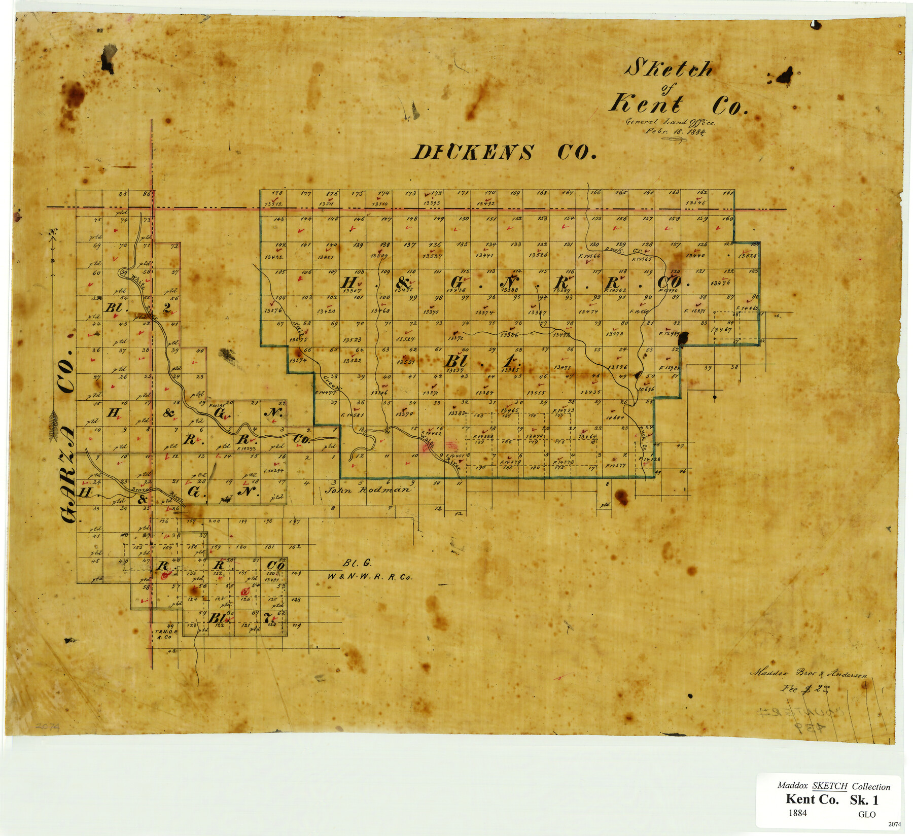
Sketch of Kent Co.
-
Map/Doc
439
-
Collection
Maddox Collection
-
Object Dates
1884/2/18 (Creation Date)
-
People and Organizations
Maddox Bros. & Anderson (Draftsman)
-
Counties
Kent Garza Dickens
-
Height x Width
15.1 x 16.5 inches
38.4 x 41.9 cm
-
Medium
linen, manuscript
-
Comments
copied for Maddox Bros. & Anderson for a fee of $2.00
-
Features
White River
Salt Creek
Duck Creek
Brazos River
Part of: Maddox Collection
[Sketch showing surveys in Sutton and Val Verde Counties, Texas]
![10779, [Sketch showing surveys in Sutton and Val Verde Counties, Texas], Maddox Collection](https://historictexasmaps.com/wmedia_w700/maps/10779.tif.jpg)
Print $20.00
- Digital $50.00
[Sketch showing surveys in Sutton and Val Verde Counties, Texas]
1880
Size 28.0 x 14.5 inches
Map/Doc 10779
Map of Swisher Addition

Print $20.00
- Digital $50.00
Map of Swisher Addition
1910
Size 18.0 x 13.1 inches
Map/Doc 83425
Map of Survey 7, Block 1, D.B. Gardner

Print $20.00
- Digital $50.00
Map of Survey 7, Block 1, D.B. Gardner
1915
Size 16.9 x 22.3 inches
Map/Doc 5067
Sketch in Hays County

Print $2.00
- Digital $50.00
Sketch in Hays County
1889
Size 8.4 x 8.3 inches
Map/Doc 5038
Bee County, Texas

Print $20.00
- Digital $50.00
Bee County, Texas
1879
Size 25.5 x 21.7 inches
Map/Doc 510
[Wm. B. Jaques assee. of José Pineda, Kimble County, Texas]
![540, [Wm. B. Jaques assee. of José Pineda, Kimble County, Texas], Maddox Collection](https://historictexasmaps.com/wmedia_w700/maps/0540.tif.jpg)
Print $3.00
- Digital $50.00
[Wm. B. Jaques assee. of José Pineda, Kimble County, Texas]
Size 16.1 x 11.2 inches
Map/Doc 540
Sherman County, Texas

Print $20.00
- Digital $50.00
Sherman County, Texas
Size 19.1 x 18.8 inches
Map/Doc 753
Map of Briscoe County, Texas

Print $20.00
- Digital $50.00
Map of Briscoe County, Texas
1879
Size 22.6 x 18.0 inches
Map/Doc 614
Map of Survey 10, Block 1, D.B. Gardner

Print $20.00
- Digital $50.00
Map of Survey 10, Block 1, D.B. Gardner
1915
Size 16.1 x 18.7 inches
Map/Doc 10764
Plat of a portion of Buchel County, Texas

Print $20.00
- Digital $50.00
Plat of a portion of Buchel County, Texas
Size 16.0 x 26.2 inches
Map/Doc 82526
[Sketch of Surveys Near Port Aransas and Aransas Pass, Aransas County, Texas]
![676, [Sketch of Surveys Near Port Aransas and Aransas Pass, Aransas County, Texas], Maddox Collection](https://historictexasmaps.com/wmedia_w700/maps/676.tif.jpg)
Print $20.00
- Digital $50.00
[Sketch of Surveys Near Port Aransas and Aransas Pass, Aransas County, Texas]
Size 22.8 x 18.5 inches
Map/Doc 676
Hopkins County

Print $20.00
- Digital $50.00
Hopkins County
1888
Size 36.4 x 36.6 inches
Map/Doc 448
You may also like
Uvalde County Sketch File 27

Print $20.00
- Digital $50.00
Uvalde County Sketch File 27
1972
Size 18.7 x 14.0 inches
Map/Doc 75972
Concho County Boundary File 2

Print $30.00
- Digital $50.00
Concho County Boundary File 2
Size 12.7 x 8.3 inches
Map/Doc 51814
Culberson County Sketch File 4

Print $56.00
- Digital $50.00
Culberson County Sketch File 4
1881
Size 14.3 x 8.8 inches
Map/Doc 20123
Howard County Sketch File 14

Print $8.00
- Digital $50.00
Howard County Sketch File 14
1940
Size 11.3 x 8.8 inches
Map/Doc 26871
Harris County Rolled Sketch 88

Print $20.00
- Digital $50.00
Harris County Rolled Sketch 88
1933
Size 34.6 x 23.1 inches
Map/Doc 6464
Wichita County Working Sketch 23

Print $20.00
- Digital $50.00
Wichita County Working Sketch 23
1963
Size 28.4 x 30.8 inches
Map/Doc 72533

Brazoria County Working Sketch 19

Print $40.00
- Digital $50.00
Brazoria County Working Sketch 19
1951
Size 50.3 x 42.3 inches
Map/Doc 67504
Spanish Province of Texas compiled from map on file among archives at Saltillo

Print $20.00
- Digital $50.00
Spanish Province of Texas compiled from map on file among archives at Saltillo
1897
Size 13.6 x 16.0 inches
Map/Doc 93412
Swisher County

Print $20.00
- Digital $50.00
Swisher County
1941
Size 44.3 x 38.1 inches
Map/Doc 73297
Willie Winn Tract

Print $2.00
- Digital $50.00
Willie Winn Tract
1903
Size 5.9 x 7.6 inches
Map/Doc 92285
Webb County Working Sketch 48

Print $20.00
- Digital $50.00
Webb County Working Sketch 48
1948
Size 28.5 x 41.4 inches
Map/Doc 72413