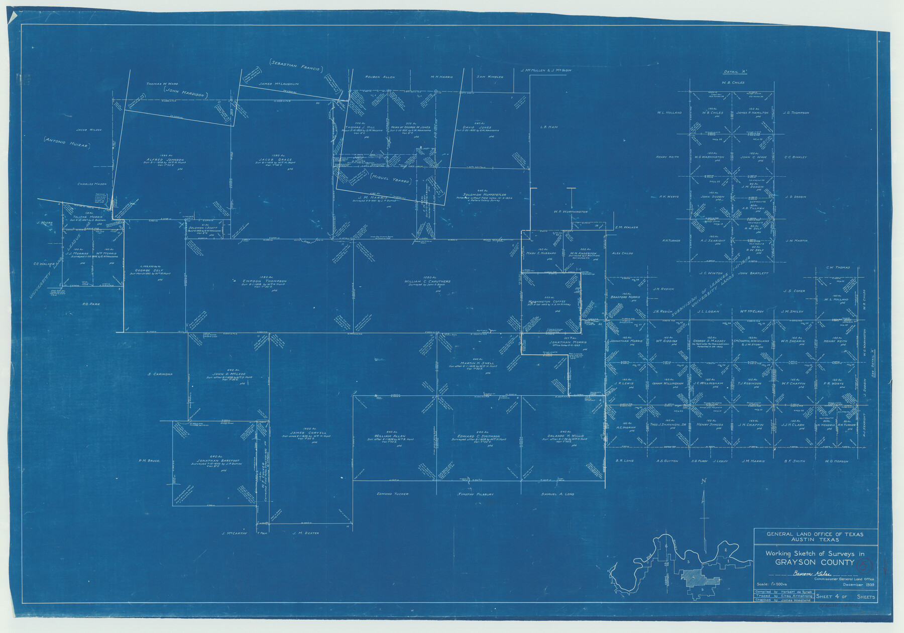
Grayson County Working Sketch 5
-
Map/Doc
63244
-
Collection
General Map Collection
-
Object Dates
12/1939 (Creation Date)
-
People and Organizations
Herbert de Synek (Compiler)
Eltea Armstrong (Tracer)
-
Counties
Grayson
-
Subjects
Surveying Working Sketch
-
Height x Width
28.4 x 40.6 inches
72.1 x 103.1 cm
-
Scale
1" = 500 varas
Part of: General Map Collection
Coleman County Sketch File 32

Print $4.00
- Digital $50.00
Coleman County Sketch File 32
Size 12.8 x 8.4 inches
Map/Doc 18723
Archer County Boundary File 1

Print $26.00
- Digital $50.00
Archer County Boundary File 1
Size 14.2 x 8.8 inches
Map/Doc 50082
Flight Mission No. DQO-2K, Frame 149, Galveston County

Print $20.00
- Digital $50.00
Flight Mission No. DQO-2K, Frame 149, Galveston County
1952
Size 18.8 x 22.4 inches
Map/Doc 85046
Liberty County Working Sketch 42

Print $20.00
- Digital $50.00
Liberty County Working Sketch 42
1953
Size 24.0 x 35.8 inches
Map/Doc 70501
San Patricio County Rolled Sketch 39

Print $20.00
- Digital $50.00
San Patricio County Rolled Sketch 39
1961
Size 40.4 x 31.7 inches
Map/Doc 7725
McLennan County Sketch File 7b

Print $6.00
- Digital $50.00
McLennan County Sketch File 7b
1857
Size 8.0 x 10.1 inches
Map/Doc 31248
Hemphill County Working Sketch 14

Print $20.00
- Digital $50.00
Hemphill County Working Sketch 14
1969
Size 34.0 x 44.8 inches
Map/Doc 66109
Orange County Working Sketch 13

Print $20.00
- Digital $50.00
Orange County Working Sketch 13
1922
Size 12.9 x 15.5 inches
Map/Doc 71345
Borden County Sketch File 6

Print $8.00
- Digital $50.00
Borden County Sketch File 6
1900
Size 11.2 x 8.7 inches
Map/Doc 14719
General Chart of the Coast No. XVI - Gulf Coast from Galveston to the Rio Grande

Print $20.00
- Digital $50.00
General Chart of the Coast No. XVI - Gulf Coast from Galveston to the Rio Grande
1883
Size 26.8 x 18.1 inches
Map/Doc 72737

Galveston County Sketch File 40

Print $18.00
- Digital $50.00
Galveston County Sketch File 40
1937
Size 14.3 x 8.8 inches
Map/Doc 23442
You may also like
Galveston County NRC Article 33.136 Sketch 60

Print $88.00
- Digital $50.00
Galveston County NRC Article 33.136 Sketch 60
2009
Size 24.0 x 36.0 inches
Map/Doc 89263
Wise County Working Sketch 8

Print $20.00
- Digital $50.00
Wise County Working Sketch 8
1953
Size 13.0 x 11.1 inches
Map/Doc 72622
Flight Mission No. DQO-2K, Frame 151, Galveston County

Print $20.00
- Digital $50.00
Flight Mission No. DQO-2K, Frame 151, Galveston County
1952
Size 18.9 x 22.6 inches
Map/Doc 85048
Kent County Working Sketch 10

Print $20.00
- Digital $50.00
Kent County Working Sketch 10
Size 34.1 x 43.0 inches
Map/Doc 70017
Houston County Working Sketch Graphic Index

Print $40.00
- Digital $50.00
Houston County Working Sketch Graphic Index
1944
Size 48.1 x 42.7 inches
Map/Doc 76582
The Republic County of Refugio. December 29, 1845

Print $20.00
The Republic County of Refugio. December 29, 1845
2020
Size 22.3 x 21.6 inches
Map/Doc 96258
Brewster County Rolled Sketch 114

Print $20.00
- Digital $50.00
Brewster County Rolled Sketch 114
1964
Size 23.8 x 18.9 inches
Map/Doc 5268
Flight Mission No. CGI-3N, Frame 187, Cameron County

Print $20.00
- Digital $50.00
Flight Mission No. CGI-3N, Frame 187, Cameron County
1954
Size 18.5 x 22.2 inches
Map/Doc 84651
General Highway Map, Irion County, Texas

Print $20.00
General Highway Map, Irion County, Texas
1940
Size 18.3 x 24.8 inches
Map/Doc 79138
Armstrong County

Print $20.00
- Digital $50.00
Armstrong County
1879
Size 21.6 x 19.2 inches
Map/Doc 3242
Presidio County Rolled Sketch 139

Print $20.00
- Digital $50.00
Presidio County Rolled Sketch 139
2002
Size 24.5 x 27.5 inches
Map/Doc 78647
Bandera County Rolled Sketch 10

Print $20.00
- Digital $50.00
Bandera County Rolled Sketch 10
1998
Size 35.4 x 38.1 inches
Map/Doc 8440