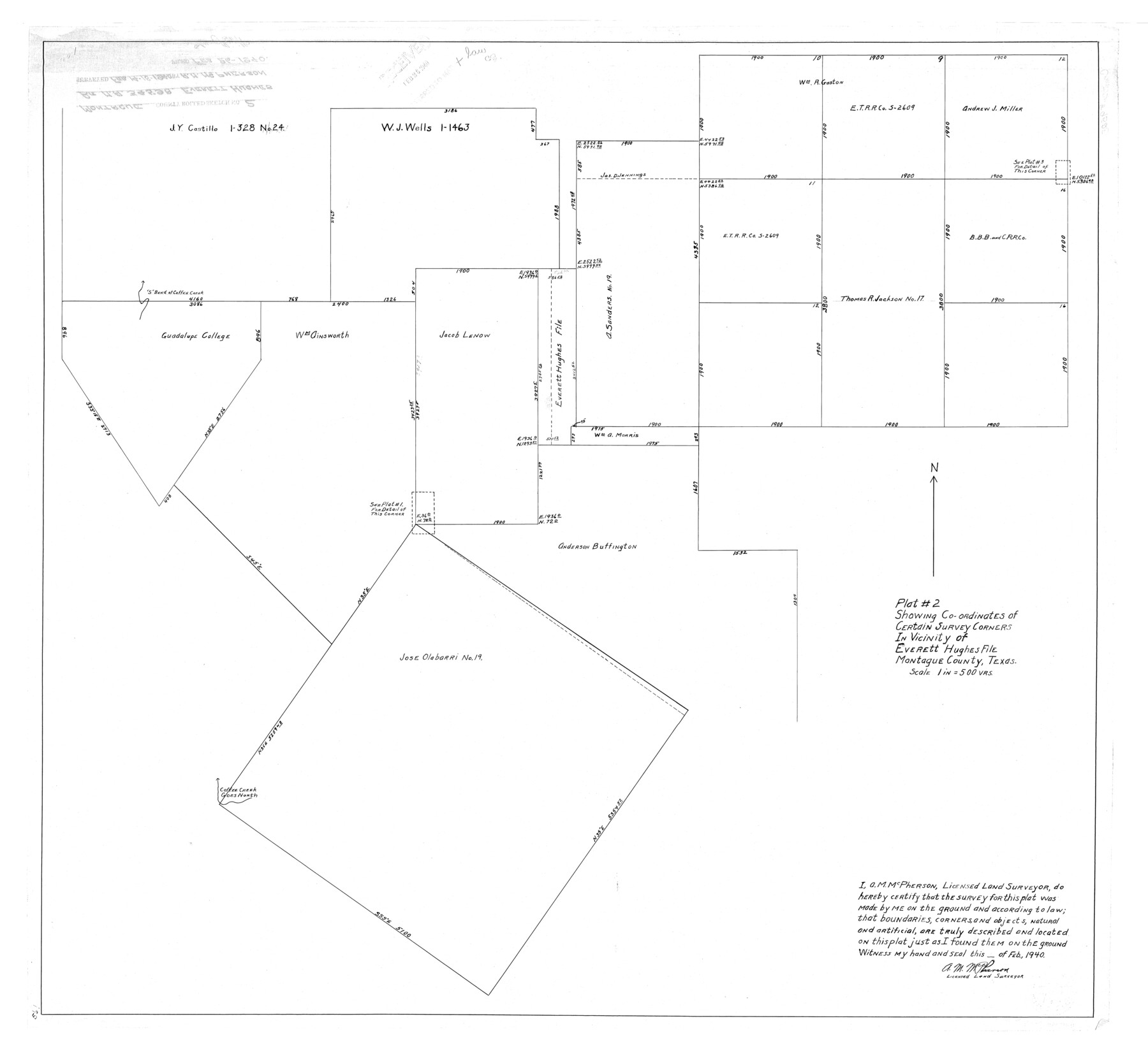
Montague County Rolled Sketch 2
Plat #2 showing co-ordinates of certain survey corners in vicinity of Everett Hughes file, Montague County, Texas
-
Map/Doc
9525
-
Collection
General Map Collection
-
Object Dates
1940/2/15 (Creation Date)
1940/2/26 (File Date)
-
People and Organizations
A.M. McPherson (Surveyor/Engineer)
-
Counties
Montague
-
Subjects
Surveying Rolled Sketch
-
Height x Width
32.5 x 35.5 inches
82.6 x 90.2 cm
-
Scale
1" = 500 varas
Part of: General Map Collection
Childress County Rolled Sketch 18

Print $20.00
- Digital $50.00
Childress County Rolled Sketch 18
1913
Size 17.6 x 39.0 inches
Map/Doc 5451
Wilbarger County Working Sketch 10

Print $20.00
- Digital $50.00
Wilbarger County Working Sketch 10
1951
Size 23.5 x 32.3 inches
Map/Doc 72548
Dimmit County Working Sketch 27

Print $20.00
- Digital $50.00
Dimmit County Working Sketch 27
1956
Size 20.3 x 23.0 inches
Map/Doc 68688
Flight Mission No. DCL-7C, Frame 135, Kenedy County

Print $20.00
- Digital $50.00
Flight Mission No. DCL-7C, Frame 135, Kenedy County
1943
Size 15.5 x 15.3 inches
Map/Doc 86092

Wilson County Working Sketch 9

Print $20.00
- Digital $50.00
Wilson County Working Sketch 9
1979
Size 31.6 x 33.0 inches
Map/Doc 72589
Upton County Working Sketch 47

Print $20.00
- Digital $50.00
Upton County Working Sketch 47
1973
Size 24.8 x 26.7 inches
Map/Doc 69543
Flight Mission No. DCL-7C, Frame 28, Kenedy County

Print $20.00
- Digital $50.00
Flight Mission No. DCL-7C, Frame 28, Kenedy County
1943
Size 15.4 x 15.4 inches
Map/Doc 86020
Webb County Working Sketch 97

Print $20.00
- Digital $50.00
Webb County Working Sketch 97
1994
Size 27.1 x 30.6 inches
Map/Doc 72464
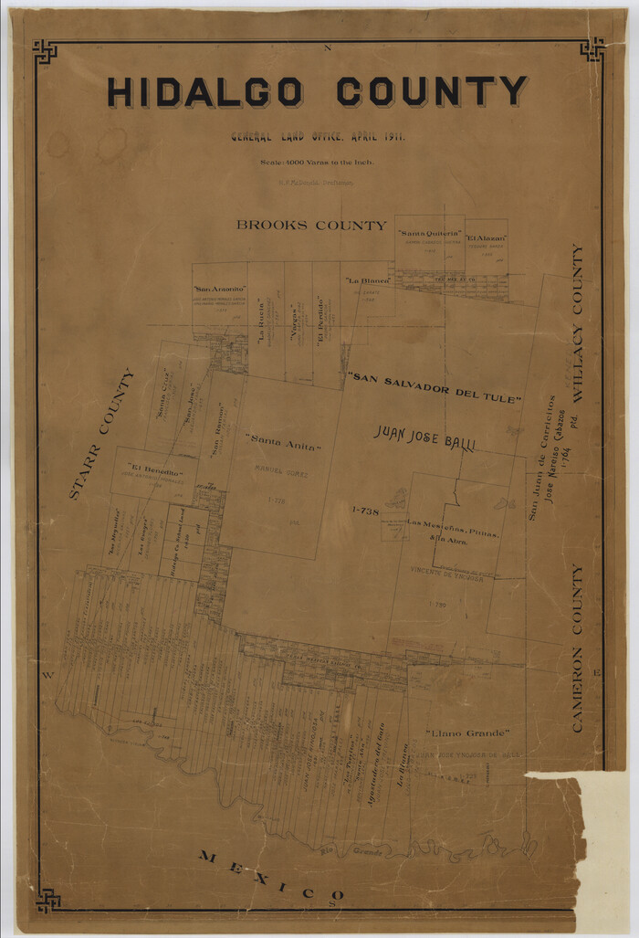
Hidalgo County
Print $20.00
- Digital $50.00
Hidalgo County
1911
Size 42.1 x 28.7 inches
Map/Doc 16850
Ochiltree County

Print $20.00
- Digital $50.00
Ochiltree County
1958
Size 44.4 x 35.5 inches
Map/Doc 95603
Lamb County Boundary File 1

Print $10.00
- Digital $50.00
Lamb County Boundary File 1
Size 11.1 x 8.5 inches
Map/Doc 56027
You may also like
Map of Henderson County

Print $20.00
- Digital $50.00
Map of Henderson County
1877
Size 17.7 x 29.2 inches
Map/Doc 3666
Shackelford County Working Sketch 3

Print $20.00
- Digital $50.00
Shackelford County Working Sketch 3
1919
Size 23.2 x 17.5 inches
Map/Doc 63843
Bexar County Working Sketch 13

Print $20.00
- Digital $50.00
Bexar County Working Sketch 13
1968
Size 43.5 x 43.7 inches
Map/Doc 67329
Matagorda County NRC Article 33.136 Sketch 19

Print $24.00
Matagorda County NRC Article 33.136 Sketch 19
2023
Map/Doc 97268
Rains County Working Sketch 2

Print $20.00
- Digital $50.00
Rains County Working Sketch 2
Size 14.0 x 12.2 inches
Map/Doc 71828
Smith County Rolled Sketch 3

Print $40.00
- Digital $50.00
Smith County Rolled Sketch 3
Size 55.2 x 42.8 inches
Map/Doc 9934
[Sketch of parts of Blocks M6, 2Z and B5]
![91934, [Sketch of parts of Blocks M6, 2Z and B5], Twichell Survey Records](https://historictexasmaps.com/wmedia_w700/maps/91934-1.tif.jpg)
Print $20.00
- Digital $50.00
[Sketch of parts of Blocks M6, 2Z and B5]
1917
Size 43.1 x 20.9 inches
Map/Doc 91934
United States - Gulf Coast Texas - Southern part of Laguna Madre

Print $20.00
- Digital $50.00
United States - Gulf Coast Texas - Southern part of Laguna Madre
1933
Size 26.6 x 18.3 inches
Map/Doc 72951
Mrs. John H. Dean Ranch, Cochran County, Texas

Print $20.00
- Digital $50.00
Mrs. John H. Dean Ranch, Cochran County, Texas
Size 25.4 x 21.1 inches
Map/Doc 92516
Wichita County Sketch File 12

Print $6.00
- Digital $50.00
Wichita County Sketch File 12
1881
Size 10.2 x 8.3 inches
Map/Doc 40074
Flight Mission No. DQO-8K, Frame 44, Galveston County

Print $20.00
- Digital $50.00
Flight Mission No. DQO-8K, Frame 44, Galveston County
1952
Size 18.5 x 22.3 inches
Map/Doc 85151
Loving County Working Sketch 3

Print $20.00
- Digital $50.00
Loving County Working Sketch 3
1941
Size 18.0 x 42.2 inches
Map/Doc 70635