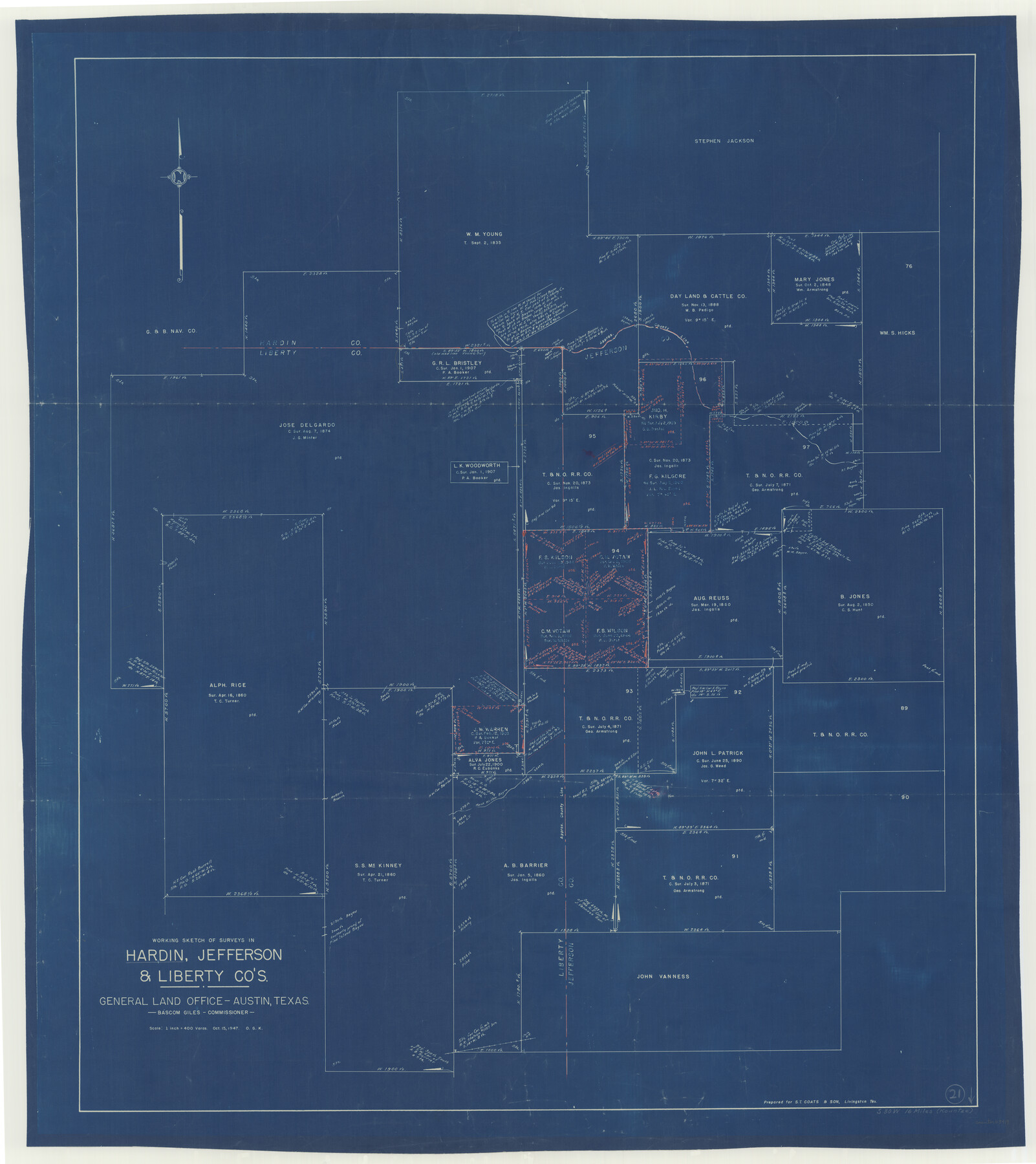
Hardin County Working Sketch 21
-
Map/Doc
63419
-
Collection
General Map Collection
-
Object Dates
10/15/1947 (Creation Date)
-
People and Organizations
Otto G. Kurio (Draftsman)
-
Counties
Hardin Jefferson Liberty
-
Subjects
Surveying Working Sketch
-
Height x Width
43.2 x 38.4 inches
109.7 x 97.5 cm
-
Scale
1" = 400 varas
Part of: General Map Collection
Duval County Sketch File 8c

Print $4.00
- Digital $50.00
Duval County Sketch File 8c
1875
Size 10.9 x 8.6 inches
Map/Doc 21300
Wood County Rolled Sketch 2

Print $40.00
- Digital $50.00
Wood County Rolled Sketch 2
1941
Size 52.6 x 24.9 inches
Map/Doc 10160
Kendall County Working Sketch 18

Print $20.00
- Digital $50.00
Kendall County Working Sketch 18
1970
Size 43.2 x 33.3 inches
Map/Doc 66690
Hudspeth County Working Sketch 44

Print $20.00
- Digital $50.00
Hudspeth County Working Sketch 44
1982
Size 25.5 x 22.2 inches
Map/Doc 66329
Brown County Sketch File 8

Print $4.00
- Digital $50.00
Brown County Sketch File 8
1860
Size 13.4 x 8.1 inches
Map/Doc 16593
Webb County Rolled Sketch EF4

Print $20.00
- Digital $50.00
Webb County Rolled Sketch EF4
1929
Size 33.2 x 24.4 inches
Map/Doc 8226
Denton County Working Sketch 30

Print $20.00
- Digital $50.00
Denton County Working Sketch 30
1999
Size 23.2 x 30.4 inches
Map/Doc 68635
Galveston County NRC Article 33.136 Sketch 55B

Print $24.00
- Digital $50.00
Galveston County NRC Article 33.136 Sketch 55B
2007
Size 24.0 x 36.0 inches
Map/Doc 94666
Right of Way and Track Map, International & Gt. Northern Ry. operated by the International & Gt. Northern Ry. Co. Gulf Division, Mineola Branch

Print $40.00
- Digital $50.00
Right of Way and Track Map, International & Gt. Northern Ry. operated by the International & Gt. Northern Ry. Co. Gulf Division, Mineola Branch
1917
Size 27.8 x 118.1 inches
Map/Doc 64704
Titus County Boundary File 2

Print $6.00
- Digital $50.00
Titus County Boundary File 2
Size 7.7 x 6.7 inches
Map/Doc 59297
Galveston County NRC Article 33.136 Sketch 31

Print $22.00
- Digital $50.00
Galveston County NRC Article 33.136 Sketch 31
2005
Size 22.2 x 33.7 inches
Map/Doc 83280
Kimble County Working Sketch 5

Print $20.00
- Digital $50.00
Kimble County Working Sketch 5
1915
Size 17.0 x 13.4 inches
Map/Doc 70073
You may also like
Pecos County Working Sketch 100

Print $20.00
- Digital $50.00
Pecos County Working Sketch 100
1970
Size 42.9 x 31.6 inches
Map/Doc 71573
Uvalde County Working Sketch 48

Print $20.00
- Digital $50.00
Uvalde County Working Sketch 48
1980
Size 15.6 x 17.9 inches
Map/Doc 72118
Matagorda County Rolled Sketch 20

Print $20.00
- Digital $50.00
Matagorda County Rolled Sketch 20
1938
Size 25.1 x 30.6 inches
Map/Doc 6688
Flight Mission No. DIX-10P, Frame 64, Aransas County

Print $20.00
- Digital $50.00
Flight Mission No. DIX-10P, Frame 64, Aransas County
1956
Size 18.7 x 22.3 inches
Map/Doc 83925
Hood County Rolled Sketch 2

Print $20.00
- Digital $50.00
Hood County Rolled Sketch 2
1958
Size 18.0 x 27.4 inches
Map/Doc 6219
Map of Gregg County

Print $20.00
- Digital $50.00
Map of Gregg County
1874
Size 14.0 x 13.9 inches
Map/Doc 3604
Galveston County NRC Article 33.136 Sketch 7

Print $20.00
- Digital $50.00
Galveston County NRC Article 33.136 Sketch 7
2001
Size 23.7 x 37.2 inches
Map/Doc 61589
Kendall County Sketch File 26

Print $12.00
- Digital $50.00
Kendall County Sketch File 26
1950
Size 11.2 x 8.8 inches
Map/Doc 28725
Eastland County Boundary File 13

Print $68.00
- Digital $50.00
Eastland County Boundary File 13
Size 8.0 x 3.7 inches
Map/Doc 52785
Nueces County Rolled Sketch M-12

Print $20.00
- Digital $50.00
Nueces County Rolled Sketch M-12
1913
Size 24.9 x 40.0 inches
Map/Doc 7171
Current Miscellaneous File 54

Print $24.00
- Digital $50.00
Current Miscellaneous File 54
1955
Size 11.2 x 8.7 inches
Map/Doc 74042
Hockley County

Print $20.00
- Digital $50.00
Hockley County
1900
Size 41.5 x 36.7 inches
Map/Doc 16852