Kendall County Sketch File 26
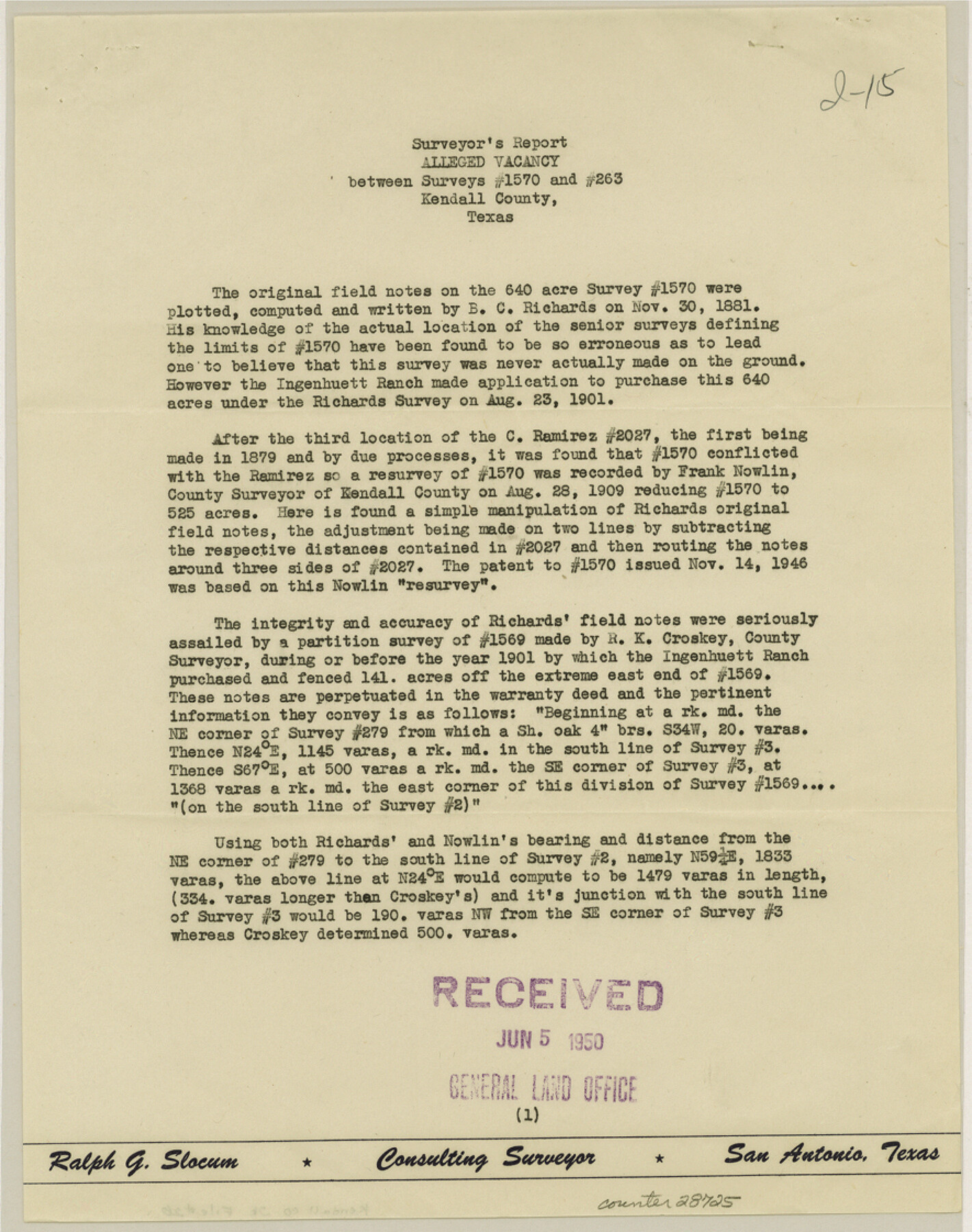
[Surveyor's report on alleged vacancy between surveys 1570 and 263]
-
Map/Doc
28725
-
Collection
General Map Collection
-
Object Dates
6/3/1950 (Creation Date)
6/19/1950 (File Date)
11/30/1881 (Survey Date)
1879 (Survey Date)
8/1849 (Survey Date)
1926 (Survey Date)
-
People and Organizations
Ralph G. Slocum (Surveyor/Engineer)
Frank Nowlin (Surveyor/Engineer)
R.K. Croskey (Surveyor/Engineer)
F.T. Drought (Surveyor/Engineer)
D.B. Scott (Surveyor/Engineer)
Joseph Chisum (Surveyor/Engineer)
-
Counties
Kendall
-
Subjects
Surveying Sketch File
-
Height x Width
11.2 x 8.8 inches
28.4 x 22.4 cm
-
Medium
paper, print
-
Features
Ingenhuett Ranch
Bear Creek
Part of: General Map Collection
Ellis County Boundary File 6

Print $22.00
- Digital $50.00
Ellis County Boundary File 6
Size 8.6 x 6.0 inches
Map/Doc 52992

Travis County Boundary File 20

Print $6.00
- Digital $50.00
Travis County Boundary File 20
Size 14.4 x 9.2 inches
Map/Doc 59454
Fort Bend County Working Sketch 12

Print $40.00
- Digital $50.00
Fort Bend County Working Sketch 12
1940
Size 29.9 x 73.2 inches
Map/Doc 69219
Rockwall County Boundary File 75

Print $18.00
- Digital $50.00
Rockwall County Boundary File 75
Size 9.0 x 11.7 inches
Map/Doc 58472
Taylor County Working Sketch 2

Print $20.00
- Digital $50.00
Taylor County Working Sketch 2
1930
Size 27.3 x 23.1 inches
Map/Doc 69611
Uvalde County Working Sketch 63

Print $20.00
- Digital $50.00
Uvalde County Working Sketch 63
1995
Size 26.8 x 42.0 inches
Map/Doc 72133
Flight Mission No. BRE-1P, Frame 45, Nueces County

Print $20.00
- Digital $50.00
Flight Mission No. BRE-1P, Frame 45, Nueces County
1956
Size 16.5 x 16.1 inches
Map/Doc 86634
Crosby County Sketch File 11a

Print $10.00
- Digital $50.00
Crosby County Sketch File 11a
1894
Size 8.7 x 4.4 inches
Map/Doc 20029
Hudspeth County Sketch File AQ1

Print $4.00
- Digital $50.00
Hudspeth County Sketch File AQ1
1902
Size 10.9 x 8.7 inches
Map/Doc 26922
Chambers County Rolled Sketch 20

Print $1171.00
- Digital $50.00
Chambers County Rolled Sketch 20
Size 10.7 x 16.2 inches
Map/Doc 43987
Jeff Davis County Sketch File 30

Print $26.00
- Digital $50.00
Jeff Davis County Sketch File 30
1922
Size 14.1 x 8.5 inches
Map/Doc 28014
You may also like
Jefferson County Rolled Sketch 61C

Print $20.00
- Digital $50.00
Jefferson County Rolled Sketch 61C
1928
Size 27.2 x 40.3 inches
Map/Doc 6412
Jackson County Sketch File 21

Print $70.00
- Digital $50.00
Jackson County Sketch File 21
2000
Size 11.3 x 8.8 inches
Map/Doc 27673
Wichita County

Print $20.00
- Digital $50.00
Wichita County
1924
Size 32.1 x 39.1 inches
Map/Doc 16924
Kinney County Working Sketch 16

Print $20.00
- Digital $50.00
Kinney County Working Sketch 16
1946
Size 46.3 x 37.7 inches
Map/Doc 70198
Section 16, Block "A", Sylvan Sanders Survey

Print $20.00
- Digital $50.00
Section 16, Block "A", Sylvan Sanders Survey
1953
Size 24.7 x 16.0 inches
Map/Doc 92715
The Republic County of Colorado. December 29, 1845

Print $20.00
The Republic County of Colorado. December 29, 1845
2020
Size 18.4 x 21.7 inches
Map/Doc 96127
Trinity River, Levee Improvement Districts, Widths of Floodways/Chambers Creek

Print $6.00
- Digital $50.00
Trinity River, Levee Improvement Districts, Widths of Floodways/Chambers Creek
1921
Size 24.9 x 31.3 inches
Map/Doc 65256
Brazoria County Rolled Sketch 43

Print $20.00
- Digital $50.00
Brazoria County Rolled Sketch 43
Size 24.4 x 19.6 inches
Map/Doc 5177
Andrews County Rolled Sketch 27

Print $40.00
- Digital $50.00
Andrews County Rolled Sketch 27
1947
Size 19.0 x 118.7 inches
Map/Doc 8399
Panola County Sketch File 22

Print $40.00
- Digital $50.00
Panola County Sketch File 22
Size 15.1 x 16.0 inches
Map/Doc 33492
Knox County Sketch File 12

Print $13.00
- Digital $50.00
Knox County Sketch File 12
1889
Size 9.8 x 8.5 inches
Map/Doc 29225
[Sutton, Hale & Ector Co. School Land]
![90102, [Sutton, Hale & Ector Co. School Land], Twichell Survey Records](https://historictexasmaps.com/wmedia_w700/maps/90102-1.tif.jpg)
Print $3.00
- Digital $50.00
[Sutton, Hale & Ector Co. School Land]
Size 9.7 x 16.8 inches
Map/Doc 90102