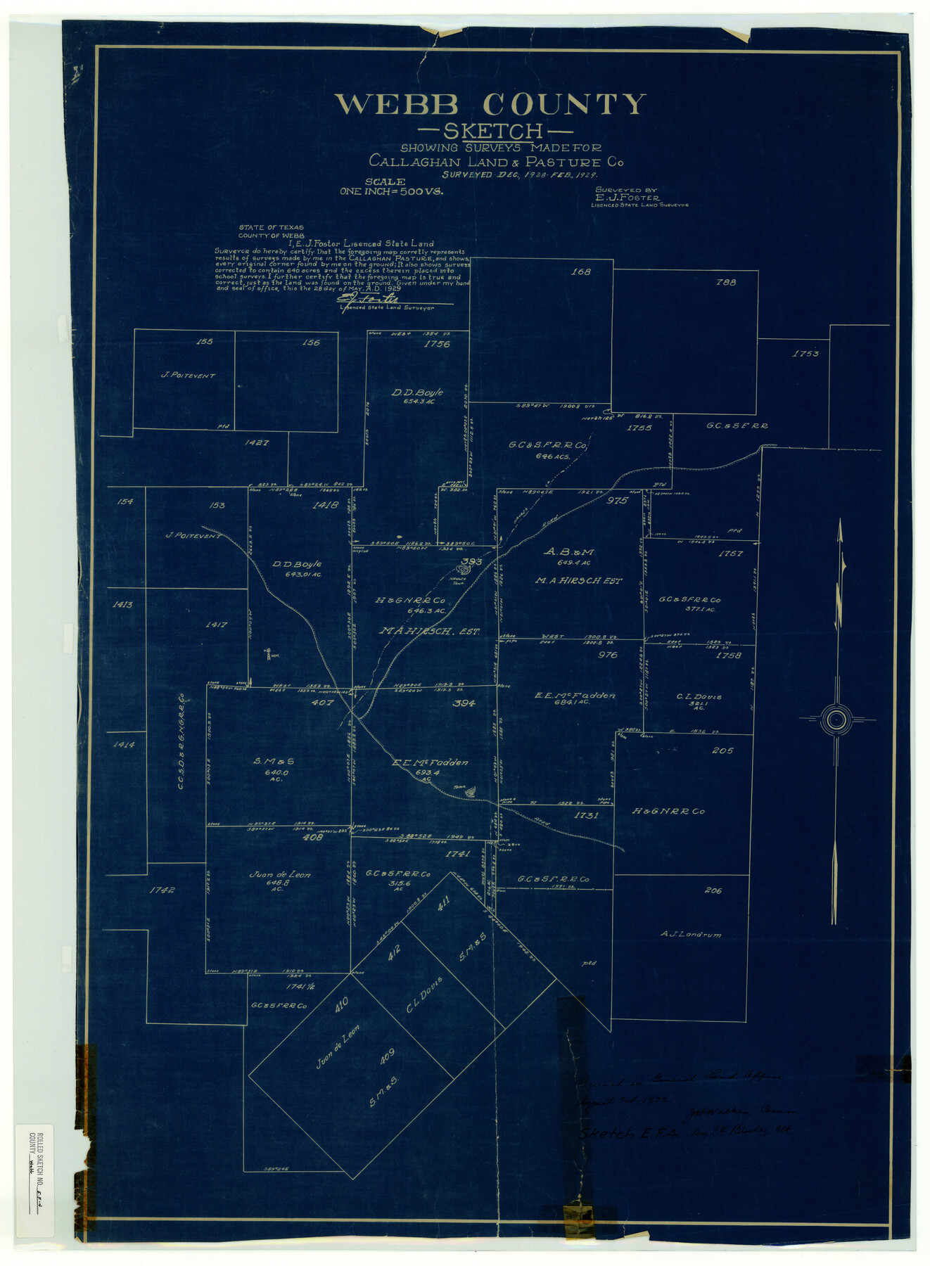
Webb County Rolled Sketch EF4
Webb County sketch showing surveys made for Callaghan Land & Pasture Co.
-
Map/Doc
8226
-
Collection
General Map Collection
-
Object Dates
1929 (Survey Date)
1932/8/3 (File Date)
1929/5/28 (Creation Date)
-
People and Organizations
E.J. Foster (Surveyor/Engineer)
-
Counties
Webb
-
Subjects
Surveying Rolled Sketch
-
Height x Width
33.2 x 24.4 inches
84.3 x 62.0 cm
-
Medium
blueprint/diazo
-
Scale
1" = 500 varas
Related maps
Webb County Sketch File EF

Print $38.00
- Digital $50.00
Webb County Sketch File EF
1932
Size 9.2 x 8.5 inches
Map/Doc 39681
Part of: General Map Collection
Map of Hidalgo County

Print $20.00
- Digital $50.00
Map of Hidalgo County
1896
Size 44.9 x 25.5 inches
Map/Doc 4684
Oldham County Rolled Sketch 9

Print $20.00
- Digital $50.00
Oldham County Rolled Sketch 9
1931
Size 13.4 x 45.2 inches
Map/Doc 7175
San Patricio County Rolled Sketch 46

Print $20.00
- Digital $50.00
San Patricio County Rolled Sketch 46
1983
Size 19.6 x 25.5 inches
Map/Doc 7730
Val Verde County Working Sketch 6

Print $20.00
- Digital $50.00
Val Verde County Working Sketch 6
1915
Size 23.2 x 20.7 inches
Map/Doc 72141
Roberts County Working Sketch 32

Print $20.00
- Digital $50.00
Roberts County Working Sketch 32
1978
Size 26.6 x 22.5 inches
Map/Doc 63558
Map of the Middle States and part of the Southern engraved to illustrate Mitchell's school and family geography

Print $20.00
- Digital $50.00
Map of the Middle States and part of the Southern engraved to illustrate Mitchell's school and family geography
1839
Size 17.8 x 11.8 inches
Map/Doc 93496
Hall County Sketch File C

Print $20.00
- Digital $50.00
Hall County Sketch File C
1905
Size 13.7 x 32.8 inches
Map/Doc 11614
Newton County Rolled Sketch 12

Print $40.00
- Digital $50.00
Newton County Rolled Sketch 12
1952
Size 38.4 x 56.1 inches
Map/Doc 9577
Sherman County Sketch File 4

Print $4.00
- Digital $50.00
Sherman County Sketch File 4
1925
Size 8.7 x 5.8 inches
Map/Doc 36688
Haskell County Boundary File 2

Print $2.00
- Digital $50.00
Haskell County Boundary File 2
Size 10.7 x 8.3 inches
Map/Doc 54538
Jeff Davis County Working Sketch 30

Print $20.00
- Digital $50.00
Jeff Davis County Working Sketch 30
1969
Size 36.1 x 31.2 inches
Map/Doc 66525
Kleberg County Rolled Sketch 10-32

Print $20.00
- Digital $50.00
Kleberg County Rolled Sketch 10-32
1952
Size 36.2 x 34.5 inches
Map/Doc 9369
You may also like
Flight Mission No. CRK-8P, Frame 119, Refugio County

Print $20.00
- Digital $50.00
Flight Mission No. CRK-8P, Frame 119, Refugio County
1956
Size 18.3 x 22.0 inches
Map/Doc 86974
C. A. Pierce's Subdivision of Dick Slaughter Land

Print $20.00
- Digital $50.00
C. A. Pierce's Subdivision of Dick Slaughter Land
1924
Size 19.0 x 8.6 inches
Map/Doc 90290
Clay County Sketch File 1

Print $22.00
- Digital $50.00
Clay County Sketch File 1
1855
Size 8.9 x 7.6 inches
Map/Doc 18386
Webb County Rolled Sketch 77

Print $20.00
- Digital $50.00
Webb County Rolled Sketch 77
1980
Size 39.1 x 38.5 inches
Map/Doc 10134
Winkler County Working Sketch 20

Print $20.00
- Digital $50.00
Winkler County Working Sketch 20
1990
Size 22.3 x 24.0 inches
Map/Doc 72614
General Highway Map, Yoakum County, Texas

Print $20.00
General Highway Map, Yoakum County, Texas
1940
Size 18.3 x 24.9 inches
Map/Doc 79285
Deaf Smith County Sketch File B

Print $20.00
- Digital $50.00
Deaf Smith County Sketch File B
Size 17.0 x 14.9 inches
Map/Doc 20626
Wilbarger County Working Sketch 16

Print $20.00
- Digital $50.00
Wilbarger County Working Sketch 16
1955
Size 32.7 x 19.9 inches
Map/Doc 72554
Flight Mission No. DIX-6P, Frame 126, Aransas County

Print $20.00
- Digital $50.00
Flight Mission No. DIX-6P, Frame 126, Aransas County
1956
Size 19.3 x 22.9 inches
Map/Doc 83832
Val Verde County Working Sketch 110

Print $20.00
- Digital $50.00
Val Verde County Working Sketch 110
1990
Size 46.3 x 42.9 inches
Map/Doc 72245
Oldham County Sketch File 10

Print $8.00
- Digital $50.00
Oldham County Sketch File 10
Size 12.7 x 8.3 inches
Map/Doc 33243
Collin County State Real Property Sketch 1

Print $20.00
- Digital $50.00
Collin County State Real Property Sketch 1
2006
Size 24.1 x 35.1 inches
Map/Doc 88634