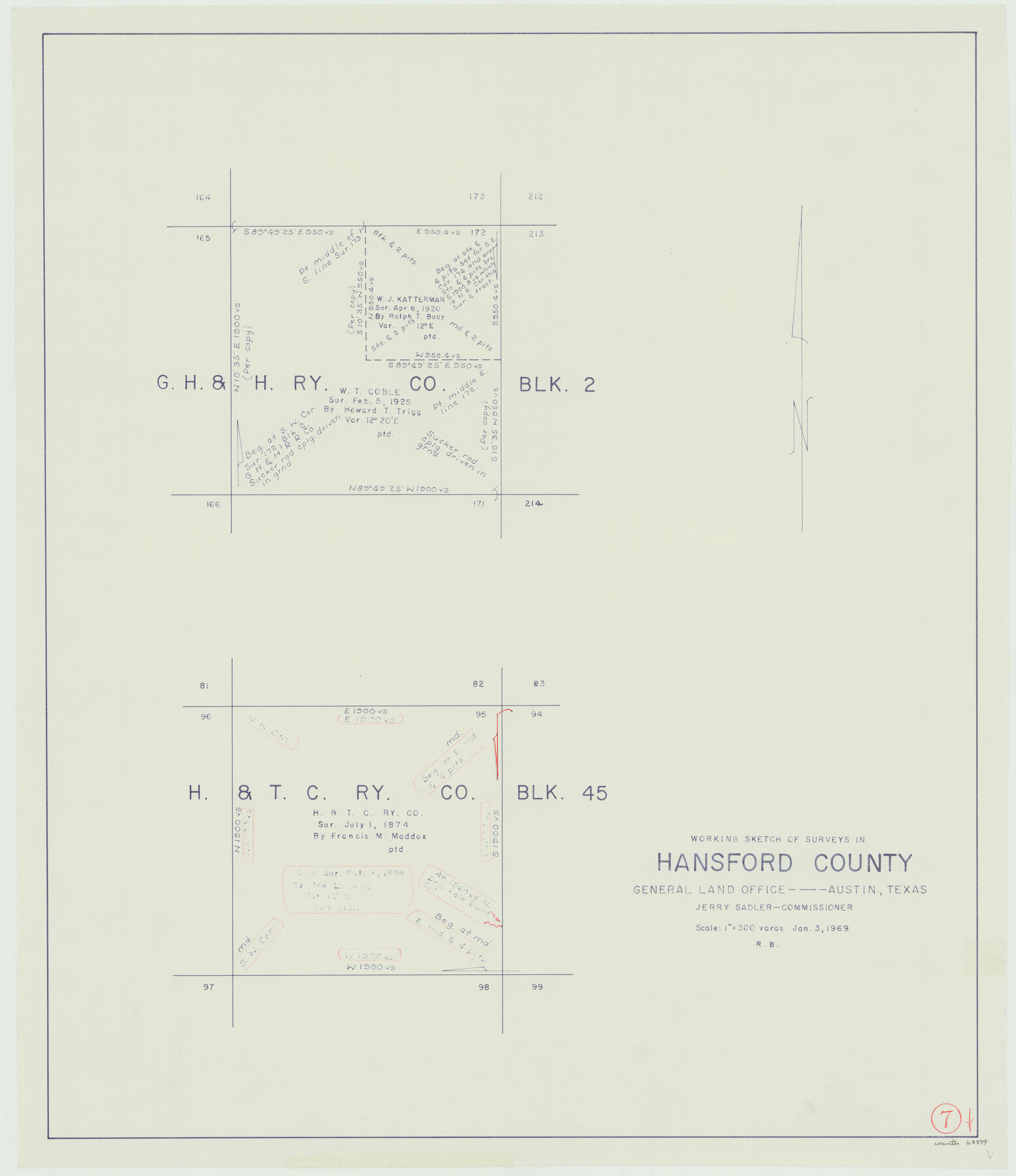
Hansford County Working Sketch 7
-
Map/Doc
63379
-
Collection
General Map Collection
-
Object Dates
1/3/1969 (Creation Date)
-
People and Organizations
Roy Buckholts (Draftsman)
-
Counties
Hansford
-
Subjects
Surveying Working Sketch
-
Height x Width
27.7 x 23.9 inches
70.4 x 60.7 cm
-
Scale
1" = 300 varas
Part of: General Map Collection
Polk County Working Sketch 21

Print $20.00
- Digital $50.00
Polk County Working Sketch 21
1953
Size 22.6 x 24.2 inches
Map/Doc 71636
Dawson County Sketch File 3

Print $20.00
- Digital $50.00
Dawson County Sketch File 3
Size 13.5 x 37.8 inches
Map/Doc 11290
Flight Mission No. DQO-8K, Frame 14, Galveston County

Print $20.00
- Digital $50.00
Flight Mission No. DQO-8K, Frame 14, Galveston County
1952
Size 18.7 x 22.4 inches
Map/Doc 85137
Trinity River, Balltown Sheet/Pilot Grove Creek

Print $20.00
- Digital $50.00
Trinity River, Balltown Sheet/Pilot Grove Creek
1938
Size 40.1 x 33.7 inches
Map/Doc 65196
Blanco County Working Sketch 32

Print $20.00
- Digital $50.00
Blanco County Working Sketch 32
1972
Size 31.8 x 32.2 inches
Map/Doc 67392
Val Verde County Working Sketch Graphic Index, Sheet 2 (Sketches 26 to 88)

Print $20.00
- Digital $50.00
Val Verde County Working Sketch Graphic Index, Sheet 2 (Sketches 26 to 88)
1944
Size 40.3 x 36.4 inches
Map/Doc 76725
Briscoe County Rolled Sketch 6

Print $20.00
- Digital $50.00
Briscoe County Rolled Sketch 6
Size 27.0 x 31.4 inches
Map/Doc 5326
United States - Gulf Coast Texas - Northern part of Laguna Madre

Print $20.00
- Digital $50.00
United States - Gulf Coast Texas - Northern part of Laguna Madre
1923
Size 26.7 x 18.3 inches
Map/Doc 72932
Flight Mission No. CLL-3N, Frame 18, Willacy County

Print $20.00
- Digital $50.00
Flight Mission No. CLL-3N, Frame 18, Willacy County
1954
Size 18.4 x 22.1 inches
Map/Doc 87084
Map of McCulloch County

Print $20.00
- Digital $50.00
Map of McCulloch County
1858
Size 26.6 x 22.4 inches
Map/Doc 3855
Terrell County Sketch File 7

Print $20.00
- Digital $50.00
Terrell County Sketch File 7
1890
Size 13.1 x 16.2 inches
Map/Doc 12418
Zavala County Sketch File 34

Print $4.00
- Digital $50.00
Zavala County Sketch File 34
1887
Size 13.0 x 8.5 inches
Map/Doc 41395
You may also like
Map of Texas Gulf Coast and Continental Shelf showing Natural Gas Pipe Lines

Print $40.00
- Digital $50.00
Map of Texas Gulf Coast and Continental Shelf showing Natural Gas Pipe Lines
1983
Size 40.9 x 59.1 inches
Map/Doc 75969
Fort Bend County Sketch File 16 1/2

Print $16.00
- Digital $50.00
Fort Bend County Sketch File 16 1/2
Size 14.3 x 8.8 inches
Map/Doc 22927
Edwards County Working Sketch 13

Print $20.00
- Digital $50.00
Edwards County Working Sketch 13
1922
Size 18.3 x 18.4 inches
Map/Doc 68889
Exhibit G Robert Violette M. A. 34719 Gaines County, Texas

Print $40.00
- Digital $50.00
Exhibit G Robert Violette M. A. 34719 Gaines County, Texas
Size 56.1 x 23.2 inches
Map/Doc 89683
Replat of Baker 2nd Addition to Lamesa, Part of Southwest Quarter, Section 71, Block 35, Dawson County, Texas

Print $20.00
- Digital $50.00
Replat of Baker 2nd Addition to Lamesa, Part of Southwest Quarter, Section 71, Block 35, Dawson County, Texas
1958
Size 9.2 x 18.0 inches
Map/Doc 92630
Williamson County Working Sketch 7

Print $20.00
- Digital $50.00
Williamson County Working Sketch 7
1949
Size 30.2 x 37.3 inches
Map/Doc 72567
[Sketch for Mineral Application 17237 / Mineral File 11855 - Neches River, Joe A. Sanders]
![2819, [Sketch for Mineral Application 17237 / Mineral File 11855 - Neches River, Joe A. Sanders], General Map Collection](https://historictexasmaps.com/wmedia_w700/maps/2819.tif.jpg)
Print $2.00
- Digital $50.00
[Sketch for Mineral Application 17237 / Mineral File 11855 - Neches River, Joe A. Sanders]
1927
Size 12.8 x 8.2 inches
Map/Doc 2819
Brown County Working Sketch 9

Print $40.00
- Digital $50.00
Brown County Working Sketch 9
1977
Size 63.7 x 36.4 inches
Map/Doc 67774
Schleicher County Rolled Sketch 15

Print $20.00
- Digital $50.00
Schleicher County Rolled Sketch 15
Size 28.8 x 41.0 inches
Map/Doc 7757
Brewster County Rolled Sketch 114

Print $20.00
- Digital $50.00
Brewster County Rolled Sketch 114
1964
Size 11.7 x 18.4 inches
Map/Doc 5265
Terry County Sketch File 10

Print $20.00
- Digital $50.00
Terry County Sketch File 10
Size 10.8 x 43.2 inches
Map/Doc 10394
