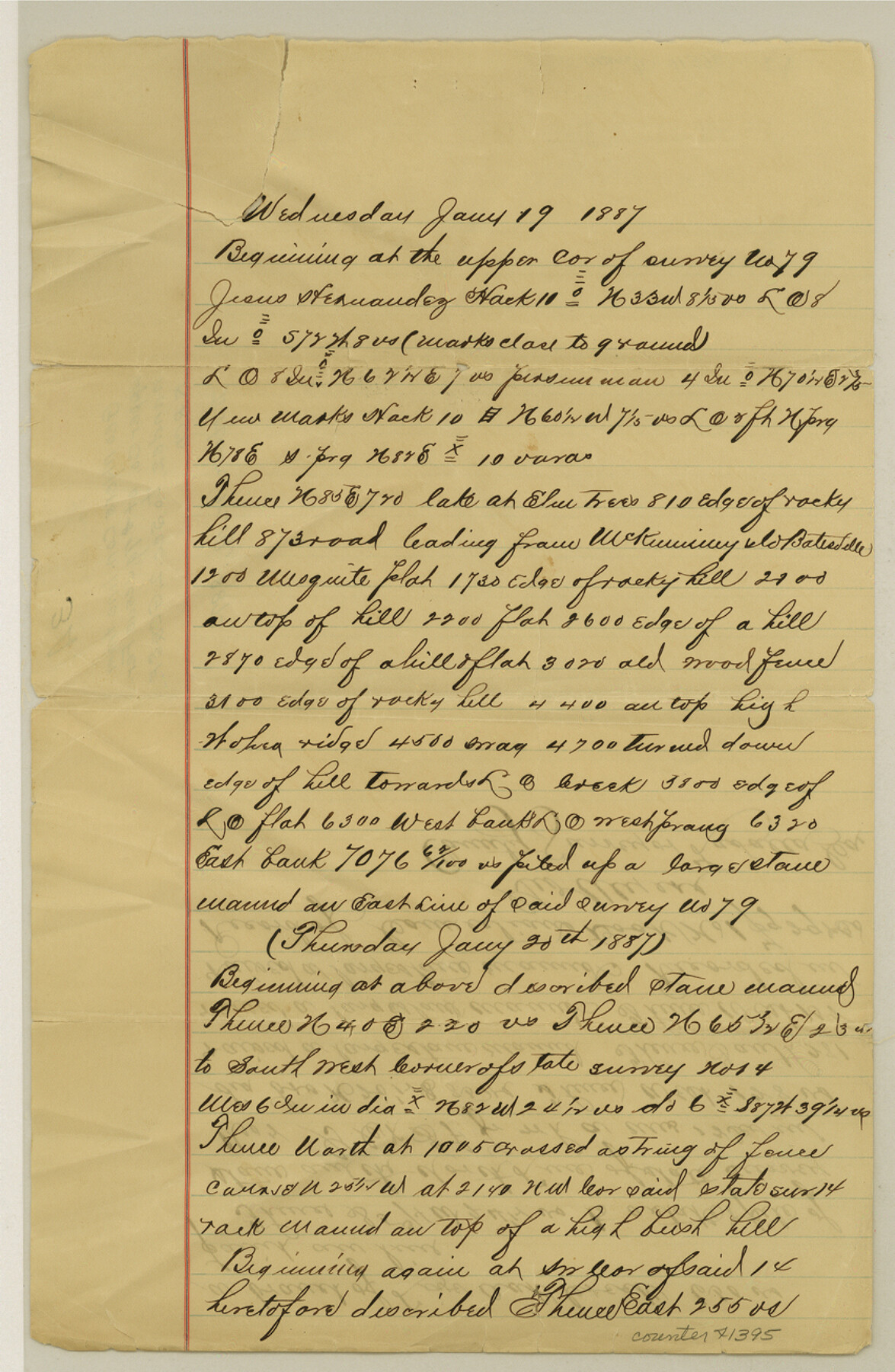
Zavala County Sketch File 34
[Connecting line from the upper corner of the Jesus Fernandez survey no. 79 to section 2, G. C. & S. F. R.R. Co.]
-
Map/Doc
41395
-
Collection
General Map Collection
-
Object Dates
1/19/1887 (Creation Date)
-
People and Organizations
George Myers (Surveyor/Engineer)
-
Counties
Zavala
-
Subjects
Surveying Sketch File
-
Height x Width
13.0 x 8.5 inches
33.0 x 21.6 cm
-
Medium
paper, manuscript
-
Features
Live Oak Creek
Part of: General Map Collection
Knox County Sketch File 27

Print $20.00
- Digital $50.00
Knox County Sketch File 27
1963
Size 20.3 x 19.7 inches
Map/Doc 11964
Flight Mission No. DQO-8K, Frame 68, Galveston County

Print $20.00
- Digital $50.00
Flight Mission No. DQO-8K, Frame 68, Galveston County
1952
Size 17.3 x 19.5 inches
Map/Doc 85172
Polk County Rolled Sketch 23

Print $20.00
- Digital $50.00
Polk County Rolled Sketch 23
Size 29.1 x 23.5 inches
Map/Doc 7313
Jasper County Sketch File 17

Print $20.00
- Digital $50.00
Jasper County Sketch File 17
1886
Size 27.5 x 35.4 inches
Map/Doc 10505
Burleson County Working Sketch 33

Print $20.00
- Digital $50.00
Burleson County Working Sketch 33
1981
Size 33.9 x 34.8 inches
Map/Doc 67752
Flight Mission No. BRA-17M, Frame 13, Jefferson County

Print $20.00
- Digital $50.00
Flight Mission No. BRA-17M, Frame 13, Jefferson County
1953
Size 18.6 x 22.3 inches
Map/Doc 85794
Travis County Rolled Sketch 11

Print $20.00
- Digital $50.00
Travis County Rolled Sketch 11
Size 23.3 x 37.9 inches
Map/Doc 8014
Reagan County Rolled Sketch 29A

Print $20.00
- Digital $50.00
Reagan County Rolled Sketch 29A
1954
Size 36.4 x 36.3 inches
Map/Doc 9825
Flight Mission No. CUG-3P, Frame 137, Kleberg County

Print $20.00
- Digital $50.00
Flight Mission No. CUG-3P, Frame 137, Kleberg County
1956
Size 18.4 x 22.2 inches
Map/Doc 86272
Southern Part of Laguna Madre

Print $20.00
- Digital $50.00
Southern Part of Laguna Madre
1969
Size 44.4 x 35.4 inches
Map/Doc 73541
Webb County Working Sketch 8

Print $20.00
- Digital $50.00
Webb County Working Sketch 8
1911
Size 43.1 x 39.9 inches
Map/Doc 72373
Nueces County Sketch File 25

Print $14.00
- Digital $50.00
Nueces County Sketch File 25
1876
Size 8.7 x 6.3 inches
Map/Doc 32572
You may also like
Topographic Map of Texas and Oklahoma Boundary, Fort Augur Area

Print $20.00
Topographic Map of Texas and Oklahoma Boundary, Fort Augur Area
1924
Size 32.3 x 33.8 inches
Map/Doc 79755
Map of Hopkins County

Print $20.00
- Digital $50.00
Map of Hopkins County
1872
Size 17.5 x 17.9 inches
Map/Doc 4567
Flight Mission No. CRC-4R, Frame 163, Chambers County

Print $20.00
- Digital $50.00
Flight Mission No. CRC-4R, Frame 163, Chambers County
1956
Size 18.5 x 22.4 inches
Map/Doc 84922
Foard County Sketch File XX

Print $40.00
- Digital $50.00
Foard County Sketch File XX
1884
Size 14.0 x 16.4 inches
Map/Doc 22802
Flight Mission No. DQN-6K, Frame 3, Calhoun County

Print $20.00
- Digital $50.00
Flight Mission No. DQN-6K, Frame 3, Calhoun County
1953
Size 18.3 x 22.1 inches
Map/Doc 84425
[South Center of County near surveys 1144 and 1143]
![90502, [South Center of County near surveys 1144 and 1143], Twichell Survey Records](https://historictexasmaps.com/wmedia_w700/maps/90502-1.tif.jpg)
Print $2.00
- Digital $50.00
[South Center of County near surveys 1144 and 1143]
Size 6.6 x 16.1 inches
Map/Doc 90502
Crockett County Rolled Sketch 46A

Print $40.00
- Digital $50.00
Crockett County Rolled Sketch 46A
Size 43.4 x 63.9 inches
Map/Doc 9199
Bandera County Working Sketch 21

Print $20.00
- Digital $50.00
Bandera County Working Sketch 21
1948
Size 21.1 x 16.7 inches
Map/Doc 67617
Hemphill County Working Sketch 1

Print $20.00
- Digital $50.00
Hemphill County Working Sketch 1
1926
Size 15.1 x 19.7 inches
Map/Doc 66096
Presidio County Rolled Sketch 91

Print $20.00
- Digital $50.00
Presidio County Rolled Sketch 91
Size 15.1 x 29.4 inches
Map/Doc 7376
Matagorda County NRC Article 33.136 Location Key Sheet

Print $20.00
- Digital $50.00
Matagorda County NRC Article 33.136 Location Key Sheet
1995
Size 27.0 x 23.0 inches
Map/Doc 87909
Collin County, Texas

Print $20.00
- Digital $50.00
Collin County, Texas
1879
Size 19.6 x 17.0 inches
Map/Doc 559