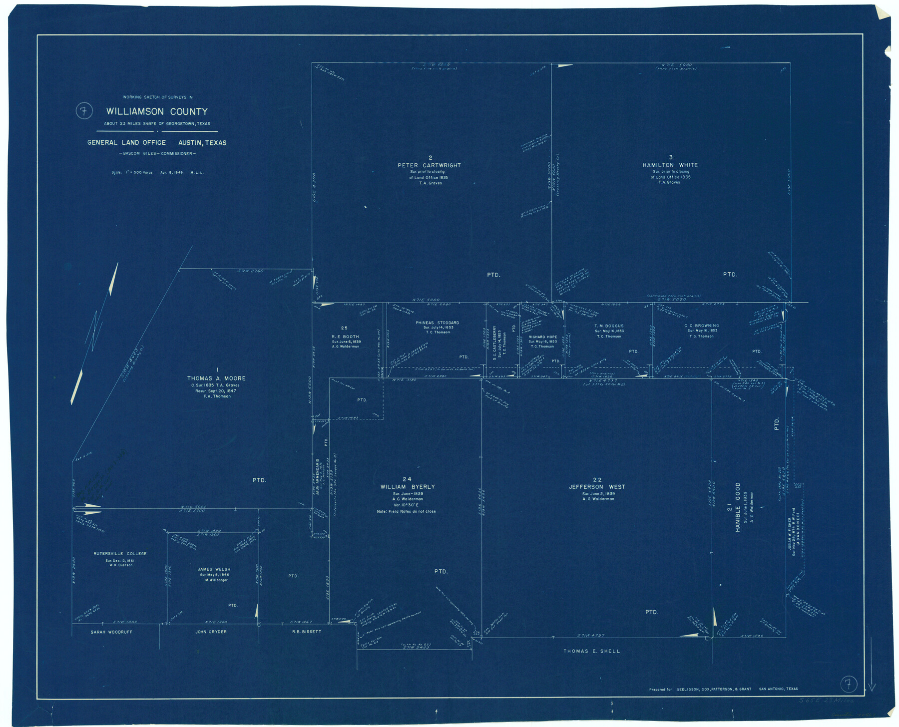
Williamson County Working Sketch 7
-
Map/Doc
72567
-
Collection
General Map Collection
-
Object Dates
4/8/1949 (Creation Date)
-
People and Organizations
M. L. Liles (Draftsman)
-
Counties
Williamson
-
Subjects
Surveying Working Sketch
-
Height x Width
30.2 x 37.3 inches
76.7 x 94.7 cm
-
Scale
1" = 500 varas
Part of: General Map Collection
Blanco County Rolled Sketch 19

Print $20.00
- Digital $50.00
Blanco County Rolled Sketch 19
Size 20.4 x 17.0 inches
Map/Doc 76409
Grayson County Sketch File 13

Print $40.00
- Digital $50.00
Grayson County Sketch File 13
1853
Size 16.2 x 14.4 inches
Map/Doc 24480
University Land Field Notes for Blocks K, L, M, and N in Hudspeth County

University Land Field Notes for Blocks K, L, M, and N in Hudspeth County
Map/Doc 81713
Jeff Davis County Rolled Sketch 16

Print $20.00
- Digital $50.00
Jeff Davis County Rolled Sketch 16
Size 27.1 x 31.7 inches
Map/Doc 6369
Ward County Working Sketch Graphic Index - sheet A

Print $40.00
- Digital $50.00
Ward County Working Sketch Graphic Index - sheet A
1932
Size 30.8 x 52.8 inches
Map/Doc 76731
Liberty County Working Sketch 35

Print $20.00
- Digital $50.00
Liberty County Working Sketch 35
1948
Size 22.3 x 42.3 inches
Map/Doc 70494

Falls County Sketch File 23

Print $20.00
- Digital $50.00
Falls County Sketch File 23
1921
Size 24.8 x 36.3 inches
Map/Doc 11467
Galveston County Rolled Sketch JK

Print $40.00
- Digital $50.00
Galveston County Rolled Sketch JK
1913
Size 25.4 x 56.5 inches
Map/Doc 9092
Galveston County Sketch File 74

Print $12.00
- Digital $50.00
Galveston County Sketch File 74
2002
Size 11.3 x 8.7 inches
Map/Doc 77526
McMullen County Rolled Sketch WSG

Print $20.00
- Digital $50.00
McMullen County Rolled Sketch WSG
Size 25.8 x 33.9 inches
Map/Doc 6738
Johnson County Boundary File 51

Print $66.00
- Digital $50.00
Johnson County Boundary File 51
Size 8.5 x 4.2 inches
Map/Doc 55589
You may also like
Harris County Working Sketch 124

Print $20.00
- Digital $50.00
Harris County Working Sketch 124
1993
Size 30.0 x 34.0 inches
Map/Doc 66016
Nolan County, Texas

Print $20.00
- Digital $50.00
Nolan County, Texas
1870
Size 23.9 x 19.5 inches
Map/Doc 744
Polk County Rolled Sketch TS

Print $40.00
- Digital $50.00
Polk County Rolled Sketch TS
1937
Size 37.9 x 58.9 inches
Map/Doc 9755
Montgomery County Sketch File 39

Print $4.00
- Digital $50.00
Montgomery County Sketch File 39
1941
Size 14.6 x 8.6 inches
Map/Doc 31923
Map of Polk County

Print $20.00
- Digital $50.00
Map of Polk County
1863
Size 21.4 x 28.5 inches
Map/Doc 3960
Upshur County Working Sketch 2

Print $20.00
- Digital $50.00
Upshur County Working Sketch 2
1934
Size 16.3 x 21.4 inches
Map/Doc 69558
Edwards County Rolled Sketch 25

Print $20.00
- Digital $50.00
Edwards County Rolled Sketch 25
1955
Size 30.2 x 35.5 inches
Map/Doc 5811
Calhoun County Rolled Sketch 3

Print $20.00
- Digital $50.00
Calhoun County Rolled Sketch 3
Size 28.0 x 21.9 inches
Map/Doc 5361
Outer Continental Shelf Leasing Maps (Louisiana Offshore Operations)

Print $20.00
- Digital $50.00
Outer Continental Shelf Leasing Maps (Louisiana Offshore Operations)
1955
Size 17.8 x 11.6 inches
Map/Doc 76083
[Sketch showing University Lands in West Texas]
![62964, [Sketch showing University Lands in West Texas], General Map Collection](https://historictexasmaps.com/wmedia_w700/maps/62964-1.tif.jpg)
Print $20.00
- Digital $50.00
[Sketch showing University Lands in West Texas]
Size 20.5 x 27.8 inches
Map/Doc 62964
Jack County Working Sketch 13

Print $20.00
- Digital $50.00
Jack County Working Sketch 13
1975
Size 25.5 x 35.8 inches
Map/Doc 66439
San Saba County Sketch File 11

Print $8.00
- Digital $50.00
San Saba County Sketch File 11
1882
Size 12.4 x 8.3 inches
Map/Doc 36435