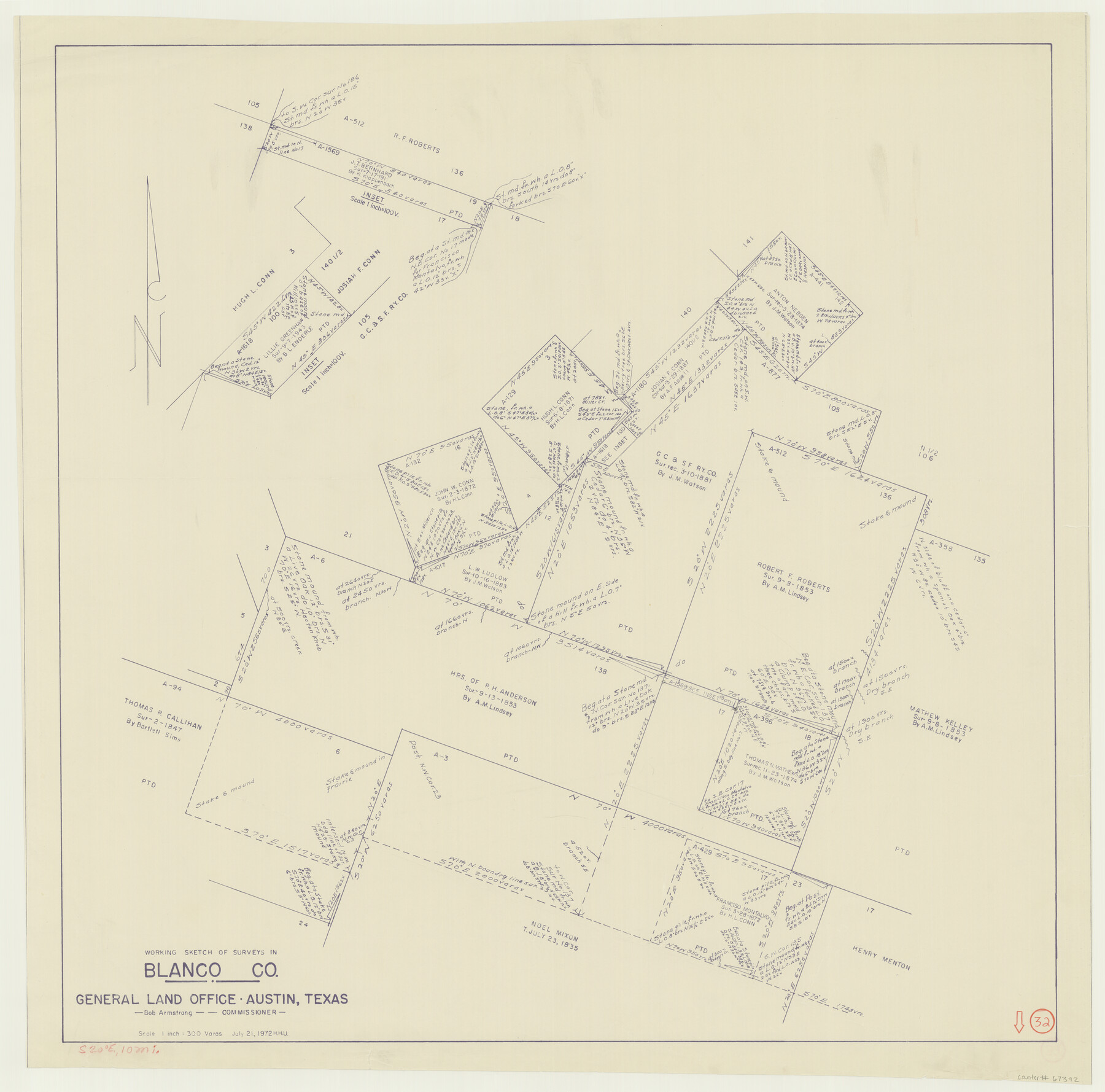
Blanco County Working Sketch 32
-
Map/Doc
67392
-
Collection
General Map Collection
-
Object Dates
7/21/1972 (Creation Date)
-
People and Organizations
Bob Armstrong (GLO Commissioner)
Herbert H. Ulbricht (Draftsman)
-
Counties
Blanco
-
Subjects
Surveying Working Sketch
-
Height x Width
31.8 x 32.2 inches
80.8 x 81.8 cm
-
Scale
1" = 300 varas
-
Comments
Surveys located about 10 miles South 20 degrees East of Johnson City, Texas.
Part of: General Map Collection
Hartley County Working Sketch 7

Print $20.00
- Digital $50.00
Hartley County Working Sketch 7
1971
Size 20.1 x 25.1 inches
Map/Doc 66057
Hudspeth County Rolled Sketch 19

Print $20.00
- Digital $50.00
Hudspeth County Rolled Sketch 19
Size 47.8 x 44.6 inches
Map/Doc 9205
Flight Mission No. DQO-3K, Frame 31, Galveston County

Print $20.00
- Digital $50.00
Flight Mission No. DQO-3K, Frame 31, Galveston County
1952
Size 18.9 x 22.5 inches
Map/Doc 85072
San Patricio County Sketch File 51

Print $12.00
- Digital $50.00
San Patricio County Sketch File 51
1917
Size 11.2 x 8.8 inches
Map/Doc 36375
Brazoria County Working Sketch 31

Print $20.00
- Digital $50.00
Brazoria County Working Sketch 31
1977
Size 26.3 x 31.7 inches
Map/Doc 67516
Flight Mission No. DCL-7C, Frame 26, Kenedy County

Print $20.00
- Digital $50.00
Flight Mission No. DCL-7C, Frame 26, Kenedy County
1943
Size 15.3 x 15.5 inches
Map/Doc 86018
[Fort Worth & Rio Grande Ry.] Map, Tracings of Located Line, Dublin to Comanche
![64353, [Fort Worth & Rio Grande Ry.] Map, Tracings of Located Line, Dublin to Comanche, General Map Collection](https://historictexasmaps.com/wmedia_w700/maps/64353.tif.jpg)
Print $20.00
- Digital $50.00
[Fort Worth & Rio Grande Ry.] Map, Tracings of Located Line, Dublin to Comanche
Size 15.3 x 41.6 inches
Map/Doc 64353
Runnels County Sketch File 5a

Print $40.00
Runnels County Sketch File 5a
1883
Size 8.9 x 22.0 inches
Map/Doc 35438
Menard County Rolled Sketch 18

Print $20.00
- Digital $50.00
Menard County Rolled Sketch 18
2024
Size 35.9 x 47.7 inches
Map/Doc 97427
Map of the Public Land States and Territories constructed from the Public Surveys and other official sources in the General Land Office

Print $20.00
- Digital $50.00
Map of the Public Land States and Territories constructed from the Public Surveys and other official sources in the General Land Office
Size 31.0 x 46.6 inches
Map/Doc 94152
[Sketch with field note calls of the boundaries of Webb, Duval, Jim Wells,Nueces, Kleberg, Zapata, Jim Hogg, Brooks, Willacy, Starr, Hidalgo and Cameron Counties]
![1689, [Sketch with field note calls of the boundaries of Webb, Duval, Jim Wells,Nueces, Kleberg, Zapata, Jim Hogg, Brooks, Willacy, Starr, Hidalgo and Cameron Counties], General Map Collection](https://historictexasmaps.com/wmedia_w700/pdf_converted_jpg/qi_pdf_thumbnail_720.jpg)
Print $20.00
- Digital $50.00
[Sketch with field note calls of the boundaries of Webb, Duval, Jim Wells,Nueces, Kleberg, Zapata, Jim Hogg, Brooks, Willacy, Starr, Hidalgo and Cameron Counties]
1915
Size 21.9 x 26.2 inches
Map/Doc 1689
Freestone County Working Sketch 11

Print $40.00
- Digital $50.00
Freestone County Working Sketch 11
1978
Size 31.4 x 51.4 inches
Map/Doc 69253
You may also like
San Saba County

Print $20.00
- Digital $50.00
San Saba County
1918
Size 46.8 x 41.2 inches
Map/Doc 63022
Briscoe County Working Sketch 12

Print $40.00
- Digital $50.00
Briscoe County Working Sketch 12
1984
Size 43.6 x 60.3 inches
Map/Doc 67815
McMullen County Sketch File 27a

Print $4.00
- Digital $50.00
McMullen County Sketch File 27a
Size 9.5 x 6.3 inches
Map/Doc 31390
Refugio District

Print $20.00
- Digital $50.00
Refugio District
1855
Size 30.7 x 34.7 inches
Map/Doc 2139
Midland County Working Sketch 1

Print $20.00
- Digital $50.00
Midland County Working Sketch 1
Size 26.8 x 8.7 inches
Map/Doc 70981
Burleson County Working Sketch 26

Print $20.00
- Digital $50.00
Burleson County Working Sketch 26
1981
Size 10.1 x 30.5 inches
Map/Doc 67745
Sutton County Sketch File H

Print $22.00
- Digital $50.00
Sutton County Sketch File H
Size 14.3 x 8.7 inches
Map/Doc 37400
Cass County Sketch File 7

Print $4.00
- Digital $50.00
Cass County Sketch File 7
1853
Size 8.0 x 12.6 inches
Map/Doc 17408
Duval County Boundary File 3h

Print $4.00
- Digital $50.00
Duval County Boundary File 3h
Size 10.0 x 8.0 inches
Map/Doc 52749
Survey 4, Block 1, D.B. Gardner

Print $20.00
- Digital $50.00
Survey 4, Block 1, D.B. Gardner
1914
Size 26.6 x 13.7 inches
Map/Doc 10769
Polk County Boundary File 1

Print $24.00
- Digital $50.00
Polk County Boundary File 1
Size 12.6 x 8.0 inches
Map/Doc 57912
Uvalde County Sketch File 25

Print $8.00
- Digital $50.00
Uvalde County Sketch File 25
1928
Size 14.5 x 8.8 inches
Map/Doc 39016