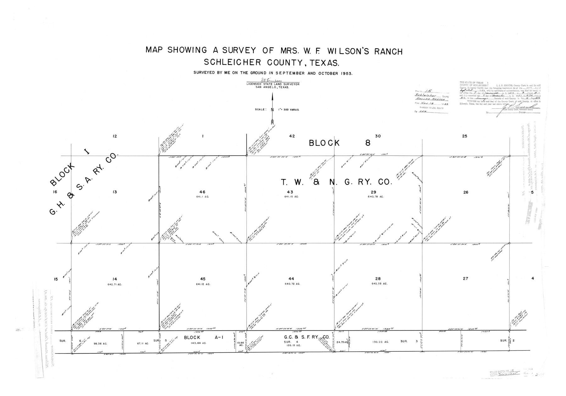
Schleicher County Rolled Sketch 15
Map showing a survey of Mrs. W.F. Wilson's Ranch, Schleicher County, Texas
-
Map/Doc
7757
-
Collection
General Map Collection
-
Object Dates
1953 (Survey Date)
1953/11/18 (File Date)
-
People and Organizations
J.A. Simpson (Surveyor/Engineer)
-
Counties
Schleicher
-
Subjects
Surveying Rolled Sketch
-
Height x Width
28.8 x 41.0 inches
73.2 x 104.1 cm
-
Scale
1" = 300 varas
Part of: General Map Collection
Houston County Sketch File 4a

Print $4.00
- Digital $50.00
Houston County Sketch File 4a
1858
Size 13.0 x 8.3 inches
Map/Doc 26754

Flight Mission No. DQN-2K, Frame 98, Calhoun County

Print $20.00
- Digital $50.00
Flight Mission No. DQN-2K, Frame 98, Calhoun County
1953
Size 18.7 x 22.4 inches
Map/Doc 84288
[Surveys in Austin's Colony at Carancahua Bay]
![172, [Surveys in Austin's Colony at Carancahua Bay], General Map Collection](https://historictexasmaps.com/wmedia_w700/maps/172.tif.jpg)
Print $20.00
- Digital $50.00
[Surveys in Austin's Colony at Carancahua Bay]
Size 22.5 x 17.4 inches
Map/Doc 172
Flight Mission No. CUG-1P, Frame 70, Kleberg County

Print $20.00
- Digital $50.00
Flight Mission No. CUG-1P, Frame 70, Kleberg County
1956
Size 18.5 x 22.3 inches
Map/Doc 86135
South Part Pecos County

Print $20.00
- Digital $50.00
South Part Pecos County
1976
Size 37.9 x 45.3 inches
Map/Doc 95613
Kendall County Working Sketch 29

Print $20.00
- Digital $50.00
Kendall County Working Sketch 29
2025
Map/Doc 97408
Hudspeth County Rolled Sketch 65

Print $40.00
- Digital $50.00
Hudspeth County Rolled Sketch 65
1988
Size 70.5 x 37.7 inches
Map/Doc 9229

Flight Mission No. BRA-3M, Frame 124, Jefferson County

Print $20.00
- Digital $50.00
Flight Mission No. BRA-3M, Frame 124, Jefferson County
1953
Size 18.6 x 21.4 inches
Map/Doc 85398
Panola County Working Sketch 29

Print $20.00
- Digital $50.00
Panola County Working Sketch 29
1980
Map/Doc 71438
West and Trans-Pecos Texas with parts of New Mexico and Mexico and a New Map of Big Bend Ranch State Park and Surrounding Area

Print $32.48
West and Trans-Pecos Texas with parts of New Mexico and Mexico and a New Map of Big Bend Ranch State Park and Surrounding Area
1988
Size 28.0 x 31.0 inches
Map/Doc 89070
You may also like
Erath County Working Sketch 33

Print $20.00
- Digital $50.00
Erath County Working Sketch 33
1972
Size 25.1 x 21.0 inches
Map/Doc 69114

Map of Spearman Lands

Print $20.00
- Digital $50.00
Map of Spearman Lands
Size 20.0 x 15.4 inches
Map/Doc 90793
Texas, Corpus Christi, Corpus Christi to Laguna Madre

Print $40.00
- Digital $50.00
Texas, Corpus Christi, Corpus Christi to Laguna Madre
1934
Size 35.1 x 48.6 inches
Map/Doc 73457
Jack County Sketch File 10

Print $4.00
- Digital $50.00
Jack County Sketch File 10
1857
Size 12.4 x 8.3 inches
Map/Doc 27527
[Mary Fury and B. H. Epperson surveys]
![93066, [Mary Fury and B. H. Epperson surveys], Twichell Survey Records](https://historictexasmaps.com/wmedia_w700/maps/93066-1.tif.jpg)
Print $3.00
- Digital $50.00
[Mary Fury and B. H. Epperson surveys]
1919
Size 10.6 x 14.6 inches
Map/Doc 93066
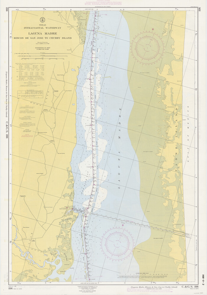
Texas Intracoastal Waterway - Laguna Madre - Rincon de San Jose to Chubby Island
Print $20.00
- Digital $50.00
Texas Intracoastal Waterway - Laguna Madre - Rincon de San Jose to Chubby Island
1961
Size 38.0 x 26.7 inches
Map/Doc 73514
Subdivisions of Hall County School Land situated in Bailey and Cockran (sic) Counties, Texas owned by G. T. Oliver, Amarillo, Tex.

Print $2.00
- Digital $50.00
Subdivisions of Hall County School Land situated in Bailey and Cockran (sic) Counties, Texas owned by G. T. Oliver, Amarillo, Tex.
1907
Size 8.3 x 15.8 inches
Map/Doc 90442
Caldwell County Working Sketch 12

Print $20.00
- Digital $50.00
Caldwell County Working Sketch 12
1979
Size 47.7 x 44.2 inches
Map/Doc 67842
Tyler County Sketch File 15

Print $6.00
- Digital $50.00
Tyler County Sketch File 15
1857
Size 10.4 x 7.5 inches
Map/Doc 38658
Travis County Sketch File 12a

Print $5.00
- Digital $50.00
Travis County Sketch File 12a
1859
Size 7.9 x 9.1 inches
Map/Doc 38308
Hays County Sketch File 34

Print $15.00
- Digital $50.00
Hays County Sketch File 34
1954
Size 14.3 x 8.9 inches
Map/Doc 26270