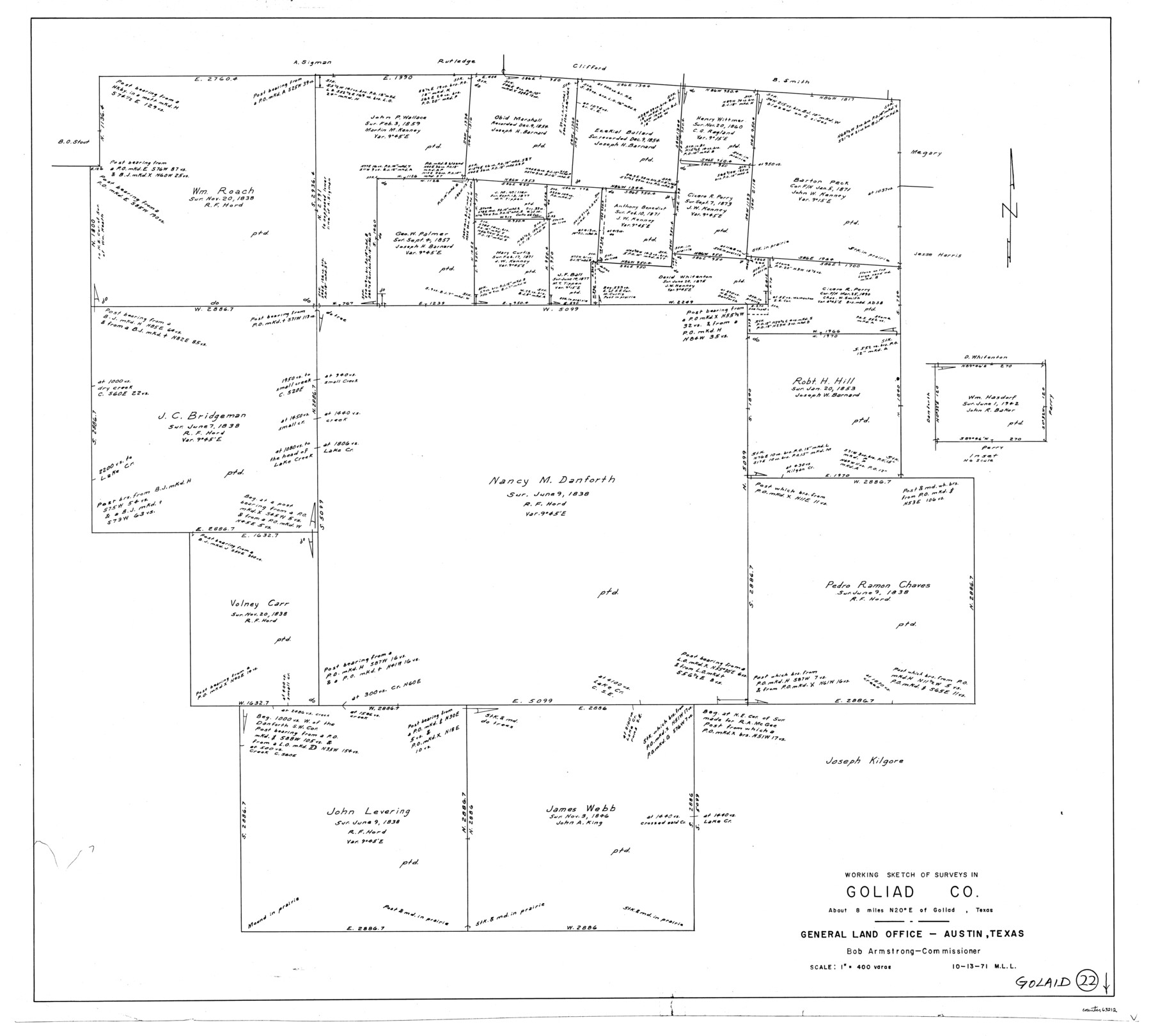
Goliad County Working Sketch 22
-
Map/Doc
63212
-
Collection
General Map Collection
-
Object Dates
10/13/1971 (Creation Date)
-
People and Organizations
M. L. Liles (Draftsman)
-
Counties
Goliad
-
Subjects
Surveying Working Sketch
-
Height x Width
33.1 x 36.8 inches
84.1 x 93.5 cm
-
Scale
1" = 400 varas
Part of: General Map Collection
Goliad County Sketch File 12

Print $18.00
- Digital $50.00
Goliad County Sketch File 12
1857
Size 12.9 x 7.9 inches
Map/Doc 24230
Chambers County Sketch File 23

Print $2.00
- Digital $50.00
Chambers County Sketch File 23
1878
Size 10.0 x 7.9 inches
Map/Doc 17597

Stonewall County Sketch File 15

Print $40.00
- Digital $50.00
Stonewall County Sketch File 15
1905
Size 14.3 x 8.7 inches
Map/Doc 37255

Map of the Texas & Pacific Ry. Reserve West of the Pecos River

Print $40.00
- Digital $50.00
Map of the Texas & Pacific Ry. Reserve West of the Pecos River
1879
Size 55.4 x 118.1 inches
Map/Doc 96439

Travis County Boundary File 25

Print $8.00
- Digital $50.00
Travis County Boundary File 25
Size 9.0 x 6.4 inches
Map/Doc 59459
Tyler County Sketch File 19a

Print $4.00
- Digital $50.00
Tyler County Sketch File 19a
Size 8.1 x 14.1 inches
Map/Doc 38672
Bee County Working Sketch 17

Print $20.00
- Digital $50.00
Bee County Working Sketch 17
1975
Size 31.5 x 33.7 inches
Map/Doc 67267
Colorado River, Sandy Creek Sheet

Print $6.00
- Digital $50.00
Colorado River, Sandy Creek Sheet
1941
Size 27.5 x 30.7 inches
Map/Doc 65319
Midland County Working Sketch Graphic Index

Print $20.00
- Digital $50.00
Midland County Working Sketch Graphic Index
1930
Size 43.3 x 35.3 inches
Map/Doc 76641
You may also like
Republic Counties. January 1, 1839

Print $20.00
Republic Counties. January 1, 1839
2020
Size 24.5 x 21.7 inches
Map/Doc 96312
Flight Mission No. CUG-1P, Frame 107, Kleberg County

Print $20.00
- Digital $50.00
Flight Mission No. CUG-1P, Frame 107, Kleberg County
1956
Size 18.5 x 22.3 inches
Map/Doc 86157
Chambers County Rolled Sketch 12

Print $20.00
- Digital $50.00
Chambers County Rolled Sketch 12
1935
Size 36.4 x 30.9 inches
Map/Doc 8613
Schleicher County Sketch File 24

Print $35.00
- Digital $50.00
Schleicher County Sketch File 24
1937
Size 10.1 x 14.8 inches
Map/Doc 36516
Marion County Sketch File 2

Print $4.00
- Digital $50.00
Marion County Sketch File 2
1853
Size 8.3 x 14.2 inches
Map/Doc 30564
Gonzales County Working Sketch 4a

Print $20.00
- Digital $50.00
Gonzales County Working Sketch 4a
1979
Size 30.9 x 32.2 inches
Map/Doc 63219
El Paso County Working Sketch 39

Print $20.00
- Digital $50.00
El Paso County Working Sketch 39
1984
Size 45.7 x 37.1 inches
Map/Doc 69061
Davis Mountains State Park Area Showing Scenic Drive

Print $20.00
Davis Mountains State Park Area Showing Scenic Drive
1935
Size 26.9 x 34.5 inches
Map/Doc 76312
[Map of Portion of Pecos County as Surveyed by F. F. Friend]
![91562, [Map of Portion of Pecos County as Surveyed by F. F. Friend], Twichell Survey Records](https://historictexasmaps.com/wmedia_w700/maps/91562-1.tif.jpg)
Print $3.00
- Digital $50.00
[Map of Portion of Pecos County as Surveyed by F. F. Friend]
1926
Size 17.0 x 11.4 inches
Map/Doc 91562
Rusk County Working Sketch 30

Print $20.00
- Digital $50.00
Rusk County Working Sketch 30
1931
Size 22.9 x 21.4 inches
Map/Doc 63667
Colorado County Sketch File 31

Print $4.00
- Digital $50.00
Colorado County Sketch File 31
1838
Size 12.8 x 7.8 inches
Map/Doc 18984
General Highway Map, Newton County, Texas

Print $20.00
General Highway Map, Newton County, Texas
1961
Size 19.3 x 25.0 inches
Map/Doc 79612