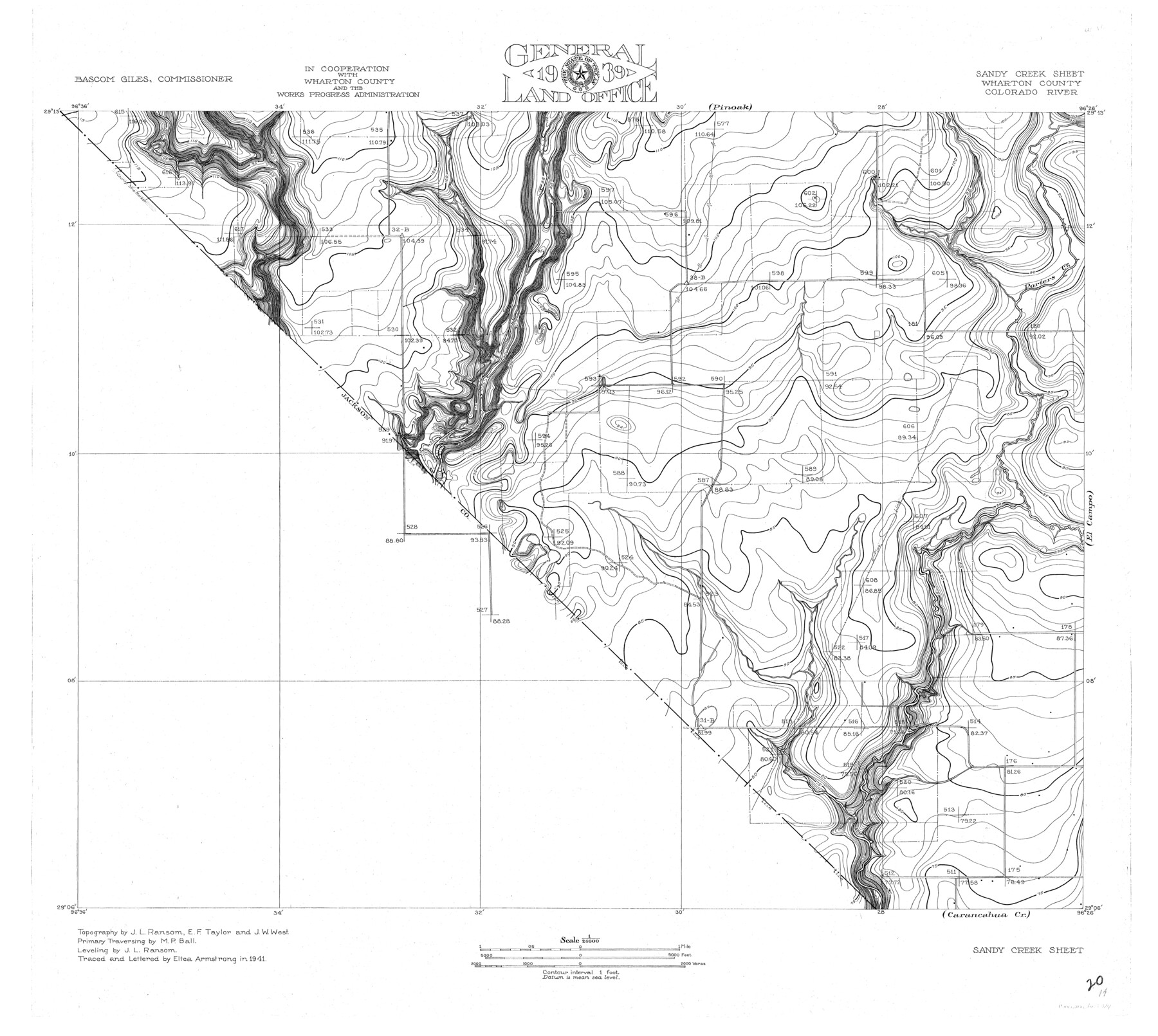
Colorado River, Sandy Creek Sheet
-
Map/Doc
65319
-
Collection
General Map Collection
-
Object Dates
1941 (Creation Date)
-
People and Organizations
Texas General Land Office (Publisher)
Bascom Giles (GLO Commissioner)
Eltea Armstrong (Draftsman)
Eltea Armstrong (Compiler)
J.L. Ransom (Surveyor/Engineer)
M.P. Ball (Surveyor/Engineer)
R.C. Wisdom (Surveyor/Engineer)
J.W. West (Surveyor/Engineer)
-
Counties
Wharton
-
Subjects
River Surveys Topographic
-
Height x Width
27.5 x 30.7 inches
69.9 x 78.0 cm
-
Comments
Sandy Creek Sheet located south of Pinoak Creek Sheet, west of the El Campo Sheet and north of the Carancahua Creek Sheet.
Part of: General Map Collection
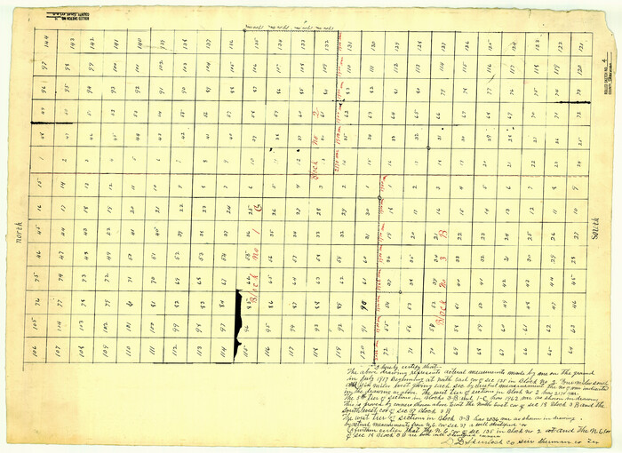
Sherman County Rolled Sketch 4
Print $20.00
- Digital $50.00
Sherman County Rolled Sketch 4
Size 23.1 x 31.7 inches
Map/Doc 7786
[Untitled Map of Baja California & West Coast of Mexico]

Print $20.00
- Digital $50.00
[Untitled Map of Baja California & West Coast of Mexico]
1541
Size 11.1 x 16.7 inches
Map/Doc 97353
San Saba County Working Sketch 9

Print $20.00
- Digital $50.00
San Saba County Working Sketch 9
1983
Size 33.8 x 42.8 inches
Map/Doc 63797
Blanco County Working Sketch 26

Print $40.00
- Digital $50.00
Blanco County Working Sketch 26
1969
Size 52.7 x 38.7 inches
Map/Doc 67386
Orange County Aerial Photograph Index Sheet 1

Print $20.00
- Digital $50.00
Orange County Aerial Photograph Index Sheet 1
1957
Size 24.1 x 20.4 inches
Map/Doc 83740
Motley County Sketch File 7 (S)

Print $4.00
- Digital $50.00
Motley County Sketch File 7 (S)
Size 8.1 x 9.6 inches
Map/Doc 32149

Cass County Working Sketch 27

Print $20.00
- Digital $50.00
Cass County Working Sketch 27
1978
Size 17.5 x 19.7 inches
Map/Doc 67930
Brown County Rolled Sketch 2B

Print $20.00
- Digital $50.00
Brown County Rolled Sketch 2B
1984
Size 24.3 x 18.6 inches
Map/Doc 5351

United States of America compiled from the latest & best Authorities

Print $20.00
- Digital $50.00
United States of America compiled from the latest & best Authorities
1818
Size 17.3 x 20.9 inches
Map/Doc 97135
Jasper County Sketch File 18

Print $32.00
- Digital $50.00
Jasper County Sketch File 18
1890
Size 12.6 x 7.9 inches
Map/Doc 27808
You may also like
Collin County Sketch File 12

Print $40.00
- Digital $50.00
Collin County Sketch File 12
1851
Size 24.3 x 31.3 inches
Map/Doc 11127
Working Sketch Cochran and Yoakum Co's.

Print $40.00
- Digital $50.00
Working Sketch Cochran and Yoakum Co's.
1919
Size 54.5 x 16.4 inches
Map/Doc 89676
Flight Mission No. CRC-4R, Frame 83, Chambers County

Print $20.00
- Digital $50.00
Flight Mission No. CRC-4R, Frame 83, Chambers County
1956
Size 18.8 x 22.5 inches
Map/Doc 84888
Comanche County Rolled Sketch 1

Print $20.00
- Digital $50.00
Comanche County Rolled Sketch 1
1985
Size 24.1 x 18.7 inches
Map/Doc 5542
Dallas County Sketch File 11

Print $12.00
- Digital $50.00
Dallas County Sketch File 11
1860
Size 8.5 x 7.9 inches
Map/Doc 20416
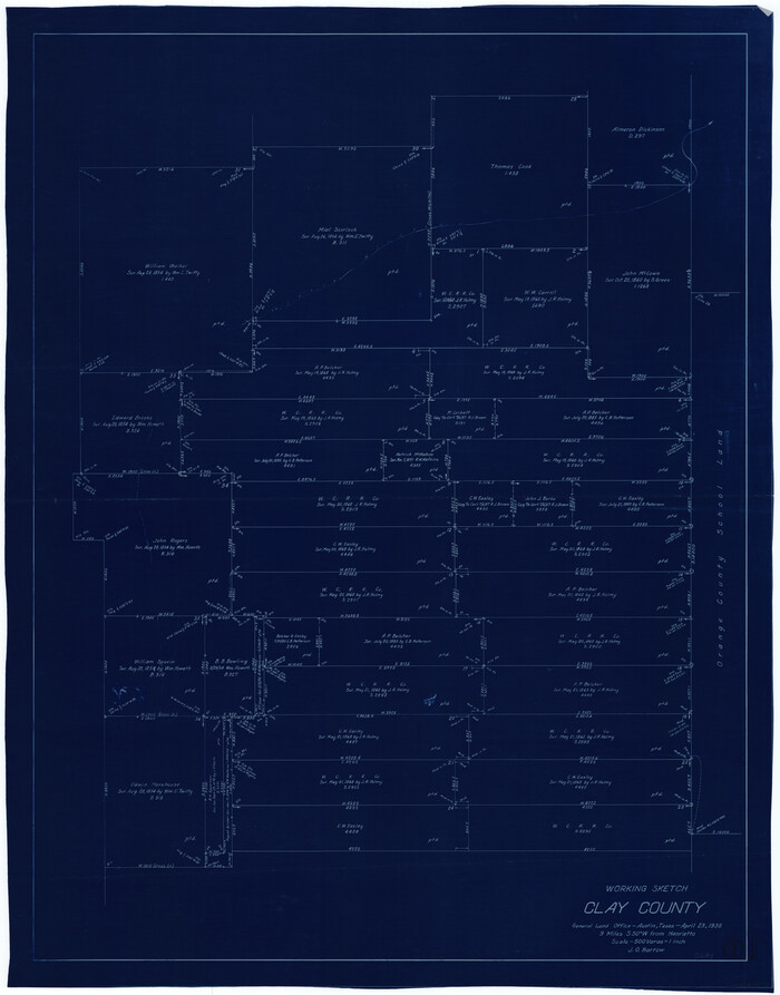
Clay County Working Sketch 9
Print $20.00
- Digital $50.00
Clay County Working Sketch 9
1938
Size 37.5 x 29.4 inches
Map/Doc 68032
Wilbarger County Sketch File 10

Print $20.00
- Digital $50.00
Wilbarger County Sketch File 10
1894
Size 33.9 x 38.7 inches
Map/Doc 10434
Live Oak County Working Sketch 24

Print $20.00
- Digital $50.00
Live Oak County Working Sketch 24
1978
Size 31.9 x 38.2 inches
Map/Doc 70609
Andrews County Rolled Sketch 33

Print $40.00
- Digital $50.00
Andrews County Rolled Sketch 33
Size 131.2 x 22.0 inches
Map/Doc 9003
Travis County Rolled Sketch 15

Print $20.00
- Digital $50.00
Travis County Rolled Sketch 15
1939
Size 25.4 x 37.6 inches
Map/Doc 10011
Galveston to Rio Grande

Print $20.00
- Digital $50.00
Galveston to Rio Grande
1941
Size 43.7 x 37.1 inches
Map/Doc 69957
Live Oak County Working Sketch 4

Print $20.00
- Digital $50.00
Live Oak County Working Sketch 4
1914
Size 16.8 x 14.0 inches
Map/Doc 70589