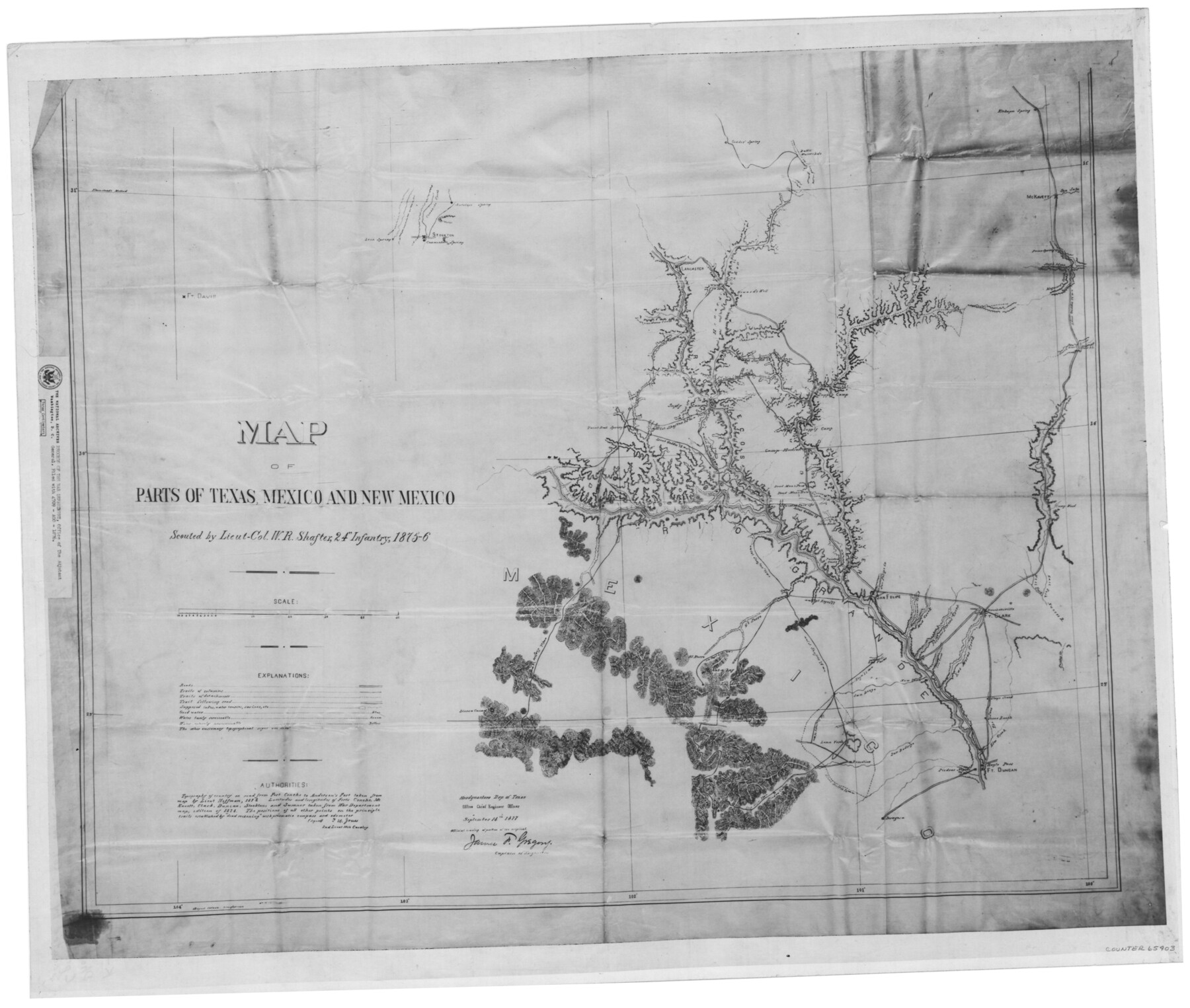
Map of parts of Texas, Mexico and New Mexico
K-7-15
- 
                          Map/Doc
65403
 - 
                            Collection
General Map Collection
 - 
                            Object Dates
9/14/1877 (Creation Date)
 - 
                            People and Organizations
James F. Gregory (Surveyor/Engineer)
 - 
                            Subjects
Military
 - 
                            Height x Width
18.1 x 21.8 inches
46.0 x 55.4 cm
 - 
                            Medium
photostat
 - 
                            Comments
Scouted by Lieut-Col. W. R. Shafter, 24th Infantry, 1875-6; Copy from National Archives - Records of the War Department, Office of the Adjutant General, Filed with 4709 - AGO - 1876
 - 
                            Features
Painted Cave Spring
Cow Creek
Piedras Pintas Creek
Las Moras Creek
Turkey Creek
Fort Clark
Brackettsville
Mud Creek
San Felipe Creek
San Felipe
Devil's River
Painted Caves
Yellow Banks Creek
Capt. Keys '77 [trail]
Dead Man's Hole
Dead Man's Pass
Nueces River
West Fork of the Nueces River
East Fork of the Nueces River
Camp Wood
Camp Hudson
Pecan Spring
Lieut. Geddes '76 [trail]
McKavett
San Saba River
Kickapoo Spring
Col. Shafter '73 [trail]
Comanche Springs
Comanche Creek
Antelope Springs
Bullis Waterhole
Lancaster
Independence Creek
Howard's Well
Howard's Canyon
Paint Rock Springs
Col. Shafter '75 [trail]
Lieut. Geddes '75 [trail]
Supply Camp
Stockton
Rio Pecos
Rio Grande
Col. Shafter '76 [trail]
Saragosa
Lieut. Bullis '76 [trail]
San Diego Creek
Fort Duncan
Eagle Pass
Elm Creek
Stone Ranch
El Burro Mountain
 
Part of: General Map Collection
            Chambers County Rolled Sketch FD2


                                            Print $20.00                    
                                             -                         Digital $50.00                                    
                Chambers County Rolled Sketch FD2
1935
Size 15.3 x 19.7 inches
                                Map/Doc 5434
            
            Township 4 North Range 13 West, North Western District, Louisiana


                                            Print $20.00                    
                                             -                         Digital $50.00                                    
                Township 4 North Range 13 West, North Western District, Louisiana
1884
Size 19.6 x 24.6 inches
                                Map/Doc 65866
            
            Flight Mission No. DQO-3K, Frame 81, Galveston County


                                            Print $20.00                    
                                             -                         Digital $50.00                                    
                Flight Mission No. DQO-3K, Frame 81, Galveston County
1952
Size 18.7 x 22.5 inches
                                Map/Doc 85086
            
            [Location St. L. & S. W. R. R. Through Cherokee County]


                                            Print $40.00                    
                                             -                         Digital $50.00                                    
                [Location St. L. & S. W. R. R. Through Cherokee County]
Size 38.7 x 76.6 inches
                                Map/Doc 64045
            
            Flight Mission No. DIX-10P, Frame 74, Aransas County


                                            Print $20.00                    
                                             -                         Digital $50.00                                    
                Flight Mission No. DIX-10P, Frame 74, Aransas County
1956
Size 18.7 x 22.4 inches
                                Map/Doc 83935
            
            Anderson County Sketch File 27


                                            Print $40.00                    
                                             -                         Digital $50.00                                    
                Anderson County Sketch File 27
1970
Size 19.5 x 23.7 inches
                                Map/Doc 10806
            
            Maps of Gulf Intracoastal Waterway, Texas - Sabine River to the Rio Grande and connecting waterways including ship channels


                                            Print $20.00                    
                                             -                         Digital $50.00                                    
                Maps of Gulf Intracoastal Waterway, Texas - Sabine River to the Rio Grande and connecting waterways including ship channels
1966
Size 14.5 x 22.1 inches
                                Map/Doc 61917
            
            Flight Mission No. DQN-7K, Frame 14, Calhoun County


                                            Print $20.00                    
                                             -                         Digital $50.00                                    
                Flight Mission No. DQN-7K, Frame 14, Calhoun County
1953
Size 17.2 x 19.1 inches
                                Map/Doc 84465
            
            [Part of Bexar District]


                                            Print $20.00                    
                                             -                         Digital $50.00                                    
                [Part of Bexar District]
1847
Size 40.9 x 27.8 inches
                                Map/Doc 1958
            
            Real County Working Sketch 13


                                            Print $20.00                    
                                             -                         Digital $50.00                                    
                Real County Working Sketch 13
1931
Size 24.2 x 33.3 inches
                                Map/Doc 71905
            
            Reeves County Working Sketch 5


                                            Print $20.00                    
                                             -                         Digital $50.00                                    
                Reeves County Working Sketch 5
1938
Size 38.0 x 32.4 inches
                                Map/Doc 63448
            
            Comanche County Working Sketch 32


                                            Print $20.00                    
                                             -                         Digital $50.00                                    
                Comanche County Working Sketch 32
1992
Size 23.5 x 38.8 inches
                                Map/Doc 68166
            You may also like
            General Highway Map, Haskell County, Texas


                                            Print $20.00                    
                                    
                General Highway Map, Haskell County, Texas
1940
Size 18.5 x 24.8 inches
                                Map/Doc 79122
            
            Galveston County Rolled Sketch 34A


                                            Print $20.00                    
                                             -                         Digital $50.00                                    
                Galveston County Rolled Sketch 34A
1978
Size 30.2 x 40.9 inches
                                Map/Doc 5967
            
            Zapata County Rolled Sketch 27


                                            Print $40.00                    
                                             -                         Digital $50.00                                    
                Zapata County Rolled Sketch 27
1988
Size 48.5 x 36.4 inches
                                Map/Doc 10173
            
            Coleman County Working Sketch 1


                                            Print $20.00                    
                                             -                         Digital $50.00                                    
                Coleman County Working Sketch 1
1900
Size 11.1 x 21.2 inches
                                Map/Doc 68067
            
            Cameron County Boundary File 1


                                            Print $14.00                    
                                             -                         Digital $50.00                                    
                Cameron County Boundary File 1
Size 14.1 x 8.6 inches
                                Map/Doc 51087
            
            Dallas County Boundary File 5a


                                            Print $4.00                    
                                             -                         Digital $50.00                                    
                Dallas County Boundary File 5a
Size 4.9 x 8.6 inches
                                Map/Doc 52182
            
            Madison County Working Sketch 14


                                            Print $4.00                    
                                             -                         Digital $50.00                                    
                Madison County Working Sketch 14
Size 24.9 x 17.0 inches
                                Map/Doc 78204
            
            Bexar County Sketch File 29


                                            Print $40.00                    
                                             -                         Digital $50.00                                    
                Bexar County Sketch File 29
Size 11.3 x 36.7 inches
                                Map/Doc 10919
            
            Duval County Sketch File 8d


                                            Print $4.00                    
                                             -                         Digital $50.00                                    
                Duval County Sketch File 8d
1869
Size 10.8 x 8.9 inches
                                Map/Doc 21302
            
            Map of the River Sabine from its mouth on the Gulf of Mexico in the Sea to Logan's Ferry in Latitude 31°58'24" North


                                            Print $40.00                    
                                             -                         Digital $50.00                                    
                Map of the River Sabine from its mouth on the Gulf of Mexico in the Sea to Logan's Ferry in Latitude 31°58'24" North
1842
Size 60.5 x 30.6 inches
                                Map/Doc 87151
            
            Lands of Gunter & Munson and Maddox Bros. & Anderson, Tom Green Co. Tex.


                                            Print $20.00                    
                                             -                         Digital $50.00                                    
                Lands of Gunter & Munson and Maddox Bros. & Anderson, Tom Green Co. Tex.
Size 20.4 x 30.7 inches
                                Map/Doc 75787
            
            [Map showing T&P Lands in El Paso County]


                                            Print $20.00                    
                                    
                [Map showing T&P Lands in El Paso County]
Size 17.3 x 22.2 inches
                                Map/Doc 88934