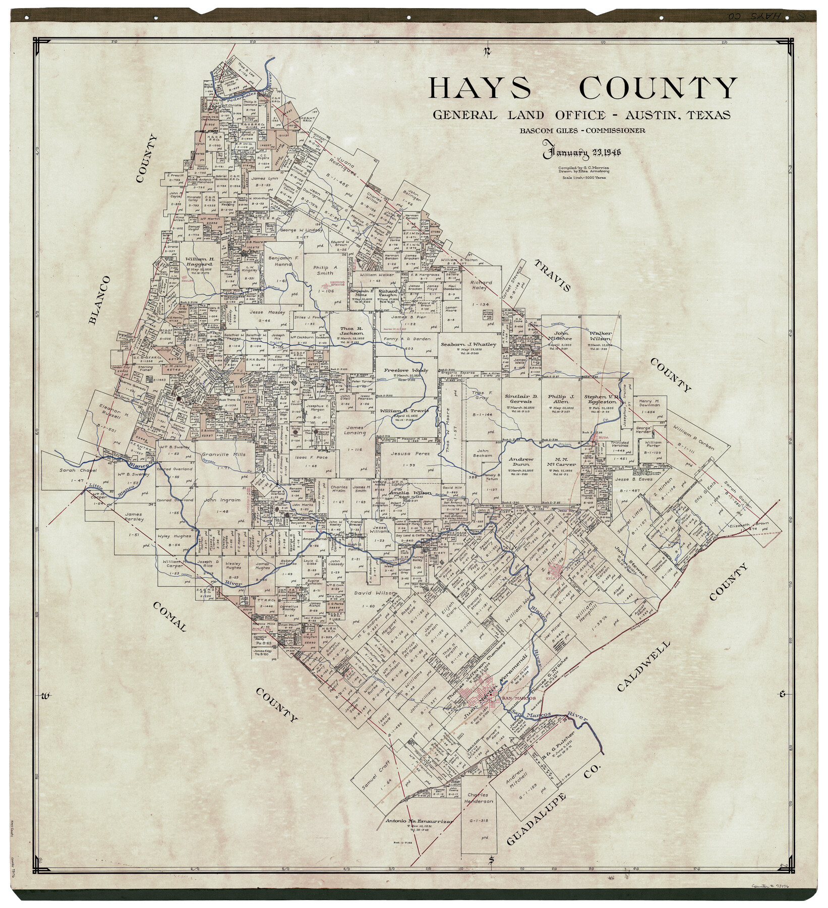
Hays County
-
Map/Doc
73176
-
Collection
General Map Collection
-
Object Dates
1/23/1946 (Creation Date)
-
People and Organizations
Texas General Land Office (Publisher)
Eltea Armstrong (Draftsman)
Bascom Giles (GLO Commissioner)
G.C. Morriss (Compiler)
-
Counties
Hays
-
Subjects
County
-
Height x Width
44.7 x 41.1 inches
113.5 x 104.4 cm
-
Comments
Hand lettered.
Note on reverse side: "Compilation completed January 23, 1946. Inking completed March 19, 1946. Tracing completed April 10, 1946. Placed in official use April 10, 1946. Replaced [on sticks] by copy June 6, 1946." -
Features
I&GN
Little Blanco River
MK&T
Purgatory Creek
San Marcos
San Marcos River
Carpers Creek
Kyle
Nacogdoches Road
San Antonio Road
San Antonio and Nacogdoches Road
Plum Creek
Halifax Creek
Wimberly [sic]
Jacob's Well
Little Twin Sister Peaks
Pedernales River
Buda
Lone Man Mountain
Lone Woman Mountain
Cypress Creek
Blanco River
Mount Sharp
Gatlin Creek
Bear Creek
Slaughter Creek
Onion Creek
Henley
Archer's Fork of Onion Creek
Dripping Springs
Barton Creek
Part of: General Map Collection
Flight Mission No. CGI-1N, Frame 170, Cameron County

Print $20.00
- Digital $50.00
Flight Mission No. CGI-1N, Frame 170, Cameron County
1955
Size 18.5 x 22.1 inches
Map/Doc 84505
Bandera County Working Sketch 13

Print $20.00
- Digital $50.00
Bandera County Working Sketch 13
1932
Size 29.1 x 25.3 inches
Map/Doc 67606
Hardeman County Working Sketch 9

Print $20.00
- Digital $50.00
Hardeman County Working Sketch 9
1953
Size 44.4 x 27.2 inches
Map/Doc 63390
Flight Mission No. CRC-5R, Frame 31, Chambers County

Print $20.00
- Digital $50.00
Flight Mission No. CRC-5R, Frame 31, Chambers County
1956
Size 18.5 x 22.4 inches
Map/Doc 84950
Harris County Sketch File 26

Print $8.00
- Digital $50.00
Harris County Sketch File 26
Size 9.2 x 8.5 inches
Map/Doc 25393
Frio County Rolled Sketch 10

Print $20.00
- Digital $50.00
Frio County Rolled Sketch 10
1945
Size 34.0 x 35.7 inches
Map/Doc 8902
Nueces River, North Extension Clarkwood Sheet

Print $2.00
- Digital $50.00
Nueces River, North Extension Clarkwood Sheet
1942
Size 14.5 x 17.7 inches
Map/Doc 65100
Reagan County Rolled Sketch 31

Print $20.00
- Digital $50.00
Reagan County Rolled Sketch 31
1955
Size 26.5 x 28.8 inches
Map/Doc 7447
Throckmorton County Rolled Sketch 3

Print $20.00
- Digital $50.00
Throckmorton County Rolled Sketch 3
1987
Size 31.2 x 36.3 inches
Map/Doc 7986
Fisher County Sketch File 19a

Print $42.00
- Digital $50.00
Fisher County Sketch File 19a
1898
Size 14.1 x 8.9 inches
Map/Doc 22595
Flight Mission No. CRE-2R, Frame 166, Jackson County

Print $20.00
- Digital $50.00
Flight Mission No. CRE-2R, Frame 166, Jackson County
1956
Size 18.5 x 22.2 inches
Map/Doc 85376
Pecos County Working Sketch 27a

Print $20.00
- Digital $50.00
Pecos County Working Sketch 27a
1931
Size 37.0 x 22.1 inches
Map/Doc 71499
You may also like
Polk County Working Sketch 18

Print $20.00
- Digital $50.00
Polk County Working Sketch 18
1949
Size 25.4 x 23.3 inches
Map/Doc 71633
Kenedy County Rolled Sketch 13

Print $20.00
- Digital $50.00
Kenedy County Rolled Sketch 13
1946
Size 38.2 x 45.5 inches
Map/Doc 9334
Flight Mission No. BQR-4K, Frame 69, Brazoria County

Print $20.00
- Digital $50.00
Flight Mission No. BQR-4K, Frame 69, Brazoria County
1952
Size 18.7 x 22.4 inches
Map/Doc 84002
Military Reconnaissance of the Arkansas Rio Del Norte and Rio Gila

Print $40.00
- Digital $50.00
Military Reconnaissance of the Arkansas Rio Del Norte and Rio Gila
1847
Size 33.0 x 72.2 inches
Map/Doc 552
Mills County Working Sketch 4

Print $3.00
- Digital $50.00
Mills County Working Sketch 4
1906
Size 10.7 x 11.7 inches
Map/Doc 71034
Flight Mission No. DAG-28K, Frame 31, Matagorda County

Print $20.00
- Digital $50.00
Flight Mission No. DAG-28K, Frame 31, Matagorda County
1953
Size 16.1 x 16.2 inches
Map/Doc 86599
Hartley County Sketch File 16

Print $4.00
- Digital $50.00
Hartley County Sketch File 16
Size 11.1 x 7.1 inches
Map/Doc 26113
Clay County Rolled Sketch 1

Print $20.00
- Digital $50.00
Clay County Rolled Sketch 1
1940
Size 47.0 x 37.9 inches
Map/Doc 8621
DeWitt County Working Sketch 11

Print $20.00
- Digital $50.00
DeWitt County Working Sketch 11
1980
Size 15.9 x 12.8 inches
Map/Doc 68601
Ward County Boundary File 1

Print $12.00
- Digital $50.00
Ward County Boundary File 1
Size 14.4 x 9.0 inches
Map/Doc 59667
Coke County Sketch File 36

Print $24.00
- Digital $50.00
Coke County Sketch File 36
1918
Size 14.1 x 8.5 inches
Map/Doc 18652
Kent County Sketch File 3

Print $4.00
- Digital $50.00
Kent County Sketch File 3
Size 14.2 x 8.7 inches
Map/Doc 28825