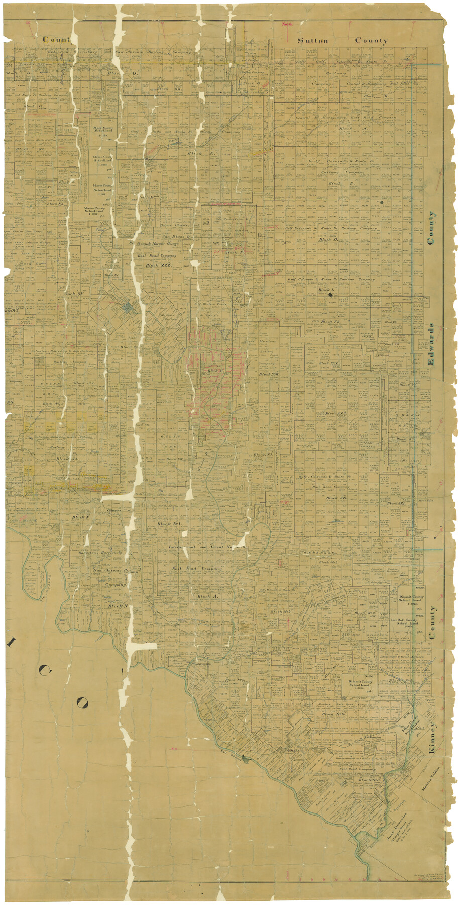
Map of Val Verde County
-
Map/Doc
16913
-
Collection
General Map Collection
-
Object Dates
9/1898 (Creation Date)
-
People and Organizations
Texas General Land Office (Publisher)
E. von Rosenberg (Draftsman)
E. von Rosenberg (Compiler)
-
Counties
Val Verde
-
Subjects
County
-
Height x Width
80.7 x 42.7 inches
205.0 x 108.5 cm
-
Comments
See counter 82013 for west part. See counter 82014 for digitally combined image.
Conservation funded in 2004 with donation from Glen Sample Ely. -
Features
Dry Branch [of San Pedro Creek]
San Felipe
Del Rio
Sienegas Spring
Arroyo los Poloncillos
Southern Pacific Railroad Company
Maverick's Creek
Sienegas Creek
Sycamore Creek
San Pedro Creek
Devil's River Station
U. S. Barracks
Stampede Creek
Middle Fork of Sycamore Creek
East Fork of San Pedro Creek
North Fork of San Pedro Creek
Goodenough Spring
Painted Creek
California Creek
Lone Hill
Griner Springs
Chalk Bluff
San Felipe Creek
GH&SA
Head Spring
Lange Cañon
Painted Cave Creek
Comstock and Ozona Road
West Prong of Painted Cave Creek
East Fork of Dolan's Creek
Pecan Spring
Yellow Bluff
Bluff Creek
North Prong of Buckley's Creek
Bandera Road
Water Creek
Mud Creek
Conical Mountain
Sugar Loaf Mountain
Poloncillo Mountain
Zacatosa Creek
Johnstone
Dolan Spring
Devils River
Sycamore Springs
Jack Springs
Jack Branch [of Dolan's Creek]
Grape Springs
Dolan's Creek
Camp Hudson
Norris Ranch
Ozona Road
Comstock Road
Ames Ranch
Ricardo Creek
Beaver Lake
Devil's Creek
Dry Creek
China Creek
Lowe's Creek
Buckley's Creek
Johnson's Ranch
McKees
Painted Cave Spring
Feely Station
East Prong of Cow Creek
Rio Grande
Rock Springs
Bullis Creek
West Fork of Sycamore Creek
West Prong of Cow Creek
Rocky Creek
Satan's Creek
Flanders
Johnson's Run [Creek]
Seminole Spring
Comstock
Almond's Rancho
Evans Creek
Cow Creek
Deadmans Creek
Red Bluff Cañon
Dry Devil's River
Dead Man's Cañon
Part of: General Map Collection
Uvalde County Working Sketch 14

Print $20.00
- Digital $50.00
Uvalde County Working Sketch 14
1943
Size 13.5 x 16.0 inches
Map/Doc 72084
Roberts County Working Sketch 32

Print $20.00
- Digital $50.00
Roberts County Working Sketch 32
1978
Size 26.6 x 22.5 inches
Map/Doc 63558
Chambers County Rolled Sketch 29

Print $20.00
- Digital $50.00
Chambers County Rolled Sketch 29
1951
Size 24.2 x 44.4 inches
Map/Doc 5429
Jim Hogg County Working Sketch 4

Print $20.00
- Digital $50.00
Jim Hogg County Working Sketch 4
1939
Size 20.9 x 25.4 inches
Map/Doc 66590
Freestone County Working Sketch 21

Print $40.00
- Digital $50.00
Freestone County Working Sketch 21
1980
Size 49.0 x 42.3 inches
Map/Doc 69263
Map of San Jacinto County

Print $20.00
- Digital $50.00
Map of San Jacinto County
1879
Size 27.0 x 18.1 inches
Map/Doc 4624
Baylor County Rolled Sketch 11

Print $20.00
- Digital $50.00
Baylor County Rolled Sketch 11
Size 19.4 x 19.9 inches
Map/Doc 5128
Haskell County Working Sketch 17

Print $20.00
- Digital $50.00
Haskell County Working Sketch 17
2011
Size 34.3 x 32.3 inches
Map/Doc 89989
Cottle County Working Sketch 23

Print $20.00
- Digital $50.00
Cottle County Working Sketch 23
1992
Size 26.6 x 24.2 inches
Map/Doc 68333
Pecos County Rolled Sketch 143

Print $74.00
- Digital $50.00
Pecos County Rolled Sketch 143
1935
Size 14.8 x 9.4 inches
Map/Doc 48359
Sutton County

Print $40.00
- Digital $50.00
Sutton County
1941
Size 43.9 x 56.1 inches
Map/Doc 73296
Wilbarger County Sketch File 9

Print $4.00
- Digital $50.00
Wilbarger County Sketch File 9
1885
Size 12.7 x 8.2 inches
Map/Doc 40181
You may also like
Dallam County Sketch File 8

Print $8.00
- Digital $50.00
Dallam County Sketch File 8
1903
Size 11.2 x 8.7 inches
Map/Doc 20353
Bosque County Sketch File 9

Print $6.00
- Digital $50.00
Bosque County Sketch File 9
1859
Size 4.3 x 4.7 inches
Map/Doc 14754
Andrews County Boundary File 2b

Print $217.00
- Digital $50.00
Andrews County Boundary File 2b
Size 9.6 x 56.0 inches
Map/Doc 49698
Texas, Brazos River, Freeport

Print $40.00
- Digital $50.00
Texas, Brazos River, Freeport
1933
Size 28.4 x 48.3 inches
Map/Doc 69994
Lipscomb County

Print $20.00
- Digital $50.00
Lipscomb County
1878
Size 18.1 x 16.4 inches
Map/Doc 3816

Smith County Rolled Sketch 1

Print $20.00
- Digital $50.00
Smith County Rolled Sketch 1
Size 42.4 x 34.8 inches
Map/Doc 9932
Jim Hogg County Sketch File 8

Print $20.00
- Digital $50.00
Jim Hogg County Sketch File 8
1941
Size 21.9 x 27.0 inches
Map/Doc 11887
[Texas & Pacific Railway through Callahan County]
![64235, [Texas & Pacific Railway through Callahan County], General Map Collection](https://historictexasmaps.com/wmedia_w700/maps/64235.tif.jpg)
Print $20.00
- Digital $50.00
[Texas & Pacific Railway through Callahan County]
1918
Size 23.2 x 8.3 inches
Map/Doc 64235
Jackson County Boundary File 1a

Print $12.00
- Digital $50.00
Jackson County Boundary File 1a
Size 12.8 x 8.0 inches
Map/Doc 55431
McMullen County

Print $40.00
- Digital $50.00
McMullen County
1918
Size 48.3 x 36.1 inches
Map/Doc 66923
Presidio County Rolled Sketch 77

Print $20.00
- Digital $50.00
Presidio County Rolled Sketch 77
1940
Size 47.1 x 43.0 inches
Map/Doc 9778