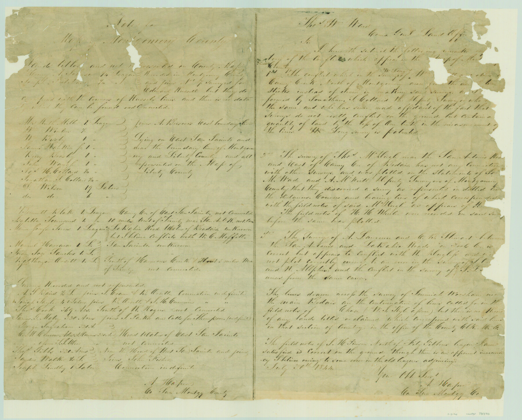
Notes for map of Montgomery County
Atlas F, Sketch 2 (F-2)
F-2
-
Map/Doc
78370
-
Collection
General Map Collection
-
Object Dates
1844 (Creation Date)
-
People and Organizations
A. Harper (Surveyor/Engineer)
-
Counties
Montgomery
-
Subjects
Atlas
-
Height x Width
17.6 x 21.9 inches
44.7 x 55.6 cm
-
Medium
paper, manuscript
-
Comments
Conserved in 2004.
Part of: General Map Collection
Reeves County Sketch File 1

Print $10.00
- Digital $50.00
Reeves County Sketch File 1
Size 9.0 x 15.8 inches
Map/Doc 35176
Reagan County Working Sketch 46a

Print $20.00
- Digital $50.00
Reagan County Working Sketch 46a
1970
Size 34.5 x 30.4 inches
Map/Doc 71888
[Corpus Christi Bay, Padre Island, Mustang Island, Laguna de la Madre, King and Kenedy's Pasture]
![73045, [Corpus Christi Bay, Padre Island, Mustang Island, Laguna de la Madre, King and Kenedy's Pasture], General Map Collection](https://historictexasmaps.com/wmedia_w700/maps/73045.tif.jpg)
Print $20.00
- Digital $50.00
[Corpus Christi Bay, Padre Island, Mustang Island, Laguna de la Madre, King and Kenedy's Pasture]
Size 26.6 x 18.1 inches
Map/Doc 73045
Refugio County Sketch File 17

Print $6.00
- Digital $50.00
Refugio County Sketch File 17
1902
Size 14.3 x 8.8 inches
Map/Doc 35272
Flight Mission No. CRC-3R, Frame 55, Chambers County

Print $20.00
- Digital $50.00
Flight Mission No. CRC-3R, Frame 55, Chambers County
1956
Size 18.6 x 22.4 inches
Map/Doc 84827
Erath County Working Sketch 15

Print $20.00
- Digital $50.00
Erath County Working Sketch 15
1961
Size 19.8 x 15.4 inches
Map/Doc 69096
Medina County Sketch File 17

Print $40.00
- Digital $50.00
Medina County Sketch File 17
1949
Size 13.1 x 13.3 inches
Map/Doc 31480
Shelby County Sketch File 31

Print $20.00
- Digital $50.00
Shelby County Sketch File 31
1949
Size 12.0 x 36.0 inches
Map/Doc 12320
Hutchinson County Rolled Sketch 36

Print $20.00
- Digital $50.00
Hutchinson County Rolled Sketch 36
1888
Size 20.3 x 25.3 inches
Map/Doc 6293
Shackelford County Working Sketch 10

Print $20.00
- Digital $50.00
Shackelford County Working Sketch 10
1984
Size 28.8 x 26.1 inches
Map/Doc 63850
Eastland County Working Sketch 20

Print $20.00
- Digital $50.00
Eastland County Working Sketch 20
1920
Size 38.0 x 23.5 inches
Map/Doc 68801
[St. Louis & Southwestern]
![64280, [St. Louis & Southwestern], General Map Collection](https://historictexasmaps.com/wmedia_w700/maps/64280.tif.jpg)
Print $20.00
- Digital $50.00
[St. Louis & Southwestern]
Size 20.3 x 27.9 inches
Map/Doc 64280
You may also like
Kent County Working Sketch 10

Print $20.00
- Digital $50.00
Kent County Working Sketch 10
Size 34.1 x 43.0 inches
Map/Doc 70017
Harrison County Rolled Sketch 15

Print $20.00
- Digital $50.00
Harrison County Rolled Sketch 15
2008
Size 20.5 x 21.0 inches
Map/Doc 89045
Texas Gulf Coast from the Sabine River to the Rio Grande Showing Subdivision for Mineral Development.

Print $40.00
- Digital $50.00
Texas Gulf Coast from the Sabine River to the Rio Grande Showing Subdivision for Mineral Development.
1958
Size 46.5 x 118.6 inches
Map/Doc 2944
Texas Gulf Coast from Sabine River to Rio Grande As Subdivided for Mineral Development - Obsolete

Print $40.00
- Digital $50.00
Texas Gulf Coast from Sabine River to Rio Grande As Subdivided for Mineral Development - Obsolete
1948
Size 42.0 x 70.8 inches
Map/Doc 2946
Andrews County Rolled Sketch 14

Print $20.00
- Digital $50.00
Andrews County Rolled Sketch 14
1934
Size 37.9 x 19.7 inches
Map/Doc 77164
Dimmit County Working Sketch 45

Print $20.00
- Digital $50.00
Dimmit County Working Sketch 45
1979
Size 44.7 x 35.5 inches
Map/Doc 68706
Flight Mission No. CRC-2R, Frame 120, Chambers County

Print $20.00
- Digital $50.00
Flight Mission No. CRC-2R, Frame 120, Chambers County
1956
Size 18.5 x 22.3 inches
Map/Doc 84744
Loving County Working Sketch 8

Print $40.00
- Digital $50.00
Loving County Working Sketch 8
1952
Size 21.9 x 56.6 inches
Map/Doc 70640
Sutton County Working Sketch 32

Print $20.00
- Digital $50.00
Sutton County Working Sketch 32
1933
Size 20.5 x 28.3 inches
Map/Doc 62375
San Jacinto County Sketch File 10

Print $5.00
San Jacinto County Sketch File 10
1859
Size 11.7 x 6.6 inches
Map/Doc 35714

Armstrong County

Print $20.00
- Digital $50.00
Armstrong County
1933
Size 39.3 x 39.4 inches
Map/Doc 77203