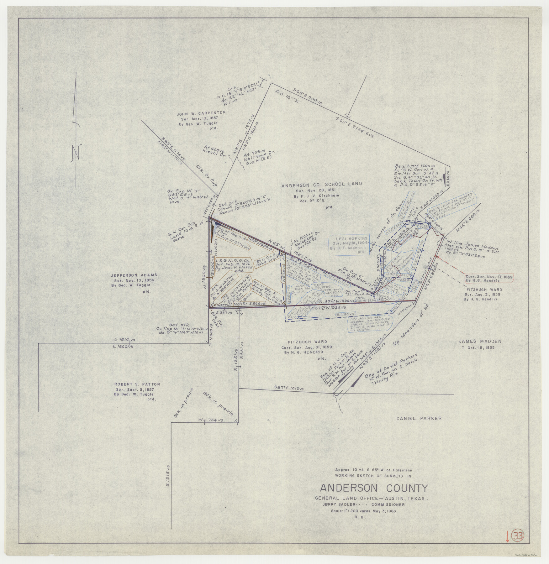
Anderson County Working Sketch 33
-
Map/Doc
67033
-
Collection
General Map Collection
-
Object Dates
5/3/1966 (Creation Date)
-
People and Organizations
Jerry Sadler (GLO Commissioner)
Roy Buckholts (Draftsman)
-
Counties
Anderson
-
Subjects
Surveying Working Sketch
-
Height x Width
30.8 x 29.9 inches
78.2 x 76.0 cm
-
Scale
1" = 200 varas
-
Comments
Surveys located about 10 miles South 65 degrees West of Palestine, Texas.
Part of: General Map Collection
Bell County Sketch File 12a

Print $6.00
- Digital $50.00
Bell County Sketch File 12a
1853
Size 12.8 x 8.0 inches
Map/Doc 14387
Flight Mission No. DCL-7C, Frame 72, Kenedy County

Print $20.00
- Digital $50.00
Flight Mission No. DCL-7C, Frame 72, Kenedy County
1943
Size 15.4 x 15.1 inches
Map/Doc 86058
Flight Mission No. BRA-7M, Frame 116, Jefferson County

Print $20.00
- Digital $50.00
Flight Mission No. BRA-7M, Frame 116, Jefferson County
1953
Size 18.6 x 22.5 inches
Map/Doc 85510
Lubbock County Working Sketch 8

Print $20.00
- Digital $50.00
Lubbock County Working Sketch 8
1989
Size 27.4 x 25.2 inches
Map/Doc 70668
Texas showing counties, cities, towns, villages and post offices, railways with stations and distances between stations

Print $40.00
- Digital $50.00
Texas showing counties, cities, towns, villages and post offices, railways with stations and distances between stations
1940
Size 45.6 x 49.4 inches
Map/Doc 4335
El Paso County Sketch File 9

Print $44.00
- Digital $50.00
El Paso County Sketch File 9
Size 8.6 x 12.5 inches
Map/Doc 21970
Pecos County Sketch File 92

Print $4.00
- Digital $50.00
Pecos County Sketch File 92
1954
Size 11.2 x 8.6 inches
Map/Doc 33988
Moore County Rolled Sketch 14

Print $20.00
- Digital $50.00
Moore County Rolled Sketch 14
1981
Size 22.6 x 26.6 inches
Map/Doc 6830
Map of Madison County

Print $20.00
- Digital $50.00
Map of Madison County
1880
Size 17.0 x 24.9 inches
Map/Doc 3832
Intracoastal Waterway in Texas - Corpus Christi to Point Isabel including Arroyo Colorado to Mo. Pac. R.R. Bridge Near Harlingen

Print $20.00
- Digital $50.00
Intracoastal Waterway in Texas - Corpus Christi to Point Isabel including Arroyo Colorado to Mo. Pac. R.R. Bridge Near Harlingen
1933
Size 27.9 x 40.9 inches
Map/Doc 61865
Hamilton County Working Sketch 5

Print $20.00
- Digital $50.00
Hamilton County Working Sketch 5
1941
Size 25.5 x 20.1 inches
Map/Doc 63343
Starr County Sketch File 45

Print $6.00
- Digital $50.00
Starr County Sketch File 45
1945
Size 14.3 x 8.7 inches
Map/Doc 36999
You may also like
Flight Mission No. DAG-24K, Frame 154, Matagorda County

Print $20.00
- Digital $50.00
Flight Mission No. DAG-24K, Frame 154, Matagorda County
1953
Size 18.5 x 22.2 inches
Map/Doc 86568
Map of the Northeast part of the Pitchfork Ranch

Print $20.00
- Digital $50.00
Map of the Northeast part of the Pitchfork Ranch
1916
Size 23.2 x 23.6 inches
Map/Doc 91046
University of Texas System University Lands

Print $20.00
- Digital $50.00
University of Texas System University Lands
1931
Size 23.2 x 17.5 inches
Map/Doc 93241
Sketch Showing Beach Groins 6th St to 39th St - Galveston, Tex.

Print $20.00
- Digital $50.00
Sketch Showing Beach Groins 6th St to 39th St - Galveston, Tex.
1928
Size 21.0 x 36.4 inches
Map/Doc 73626
Brewster County Working Sketch 25

Print $20.00
- Digital $50.00
Brewster County Working Sketch 25
1940
Size 17.0 x 18.0 inches
Map/Doc 67559
Working Sketch Archer County

Print $20.00
- Digital $50.00
Working Sketch Archer County
1924
Size 26.6 x 20.5 inches
Map/Doc 90257
Val Verde County Sketch File XXX10

Print $20.00
- Digital $50.00
Val Verde County Sketch File XXX10
Size 25.9 x 19.2 inches
Map/Doc 12549
Deaf Smith County Working Sketch Graphic Index

Print $40.00
- Digital $50.00
Deaf Smith County Working Sketch Graphic Index
1926
Size 40.1 x 52.6 inches
Map/Doc 76519
Erath County Sketch File 4

Print $8.00
- Digital $50.00
Erath County Sketch File 4
1853
Size 13.1 x 8.3 inches
Map/Doc 22259
Cameron County Rolled Sketch 19

Print $2.00
- Digital $50.00
Cameron County Rolled Sketch 19
Size 7.0 x 5.6 inches
Map/Doc 5467
Jeff Davis County Texas

Print $20.00
- Digital $50.00
Jeff Davis County Texas
Size 16.1 x 21.1 inches
Map/Doc 4572
Liberty County Working Sketch 37

Print $20.00
- Digital $50.00
Liberty County Working Sketch 37
1948
Size 25.4 x 26.8 inches
Map/Doc 70496