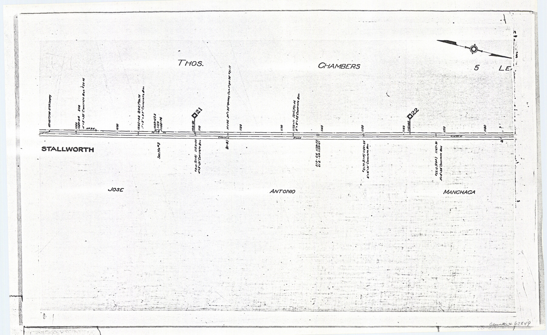
Railroad Track Map, H&TCRRCo., Falls County, Texas
Right of Way and Track Map
K-7-79 flat folder
-
Map/Doc
62849
-
Collection
General Map Collection
-
Object Dates
1918 (Creation Date)
-
Counties
Falls
-
Subjects
Railroads
-
Height x Width
11.4 x 18.7 inches
29.0 x 47.5 cm
-
Comments
Operated by the Texas and New Orleans Railroad Company, Waco Branch.
Part of: General Map Collection
Potter County Rolled Sketch 13

Print $20.00
- Digital $50.00
Potter County Rolled Sketch 13
2004
Size 18.4 x 23.4 inches
Map/Doc 82476
Shelby County Rolled Sketch 13

Print $20.00
- Digital $50.00
Shelby County Rolled Sketch 13
1945
Size 24.5 x 27.8 inches
Map/Doc 7781
Llano County Sketch File 9

Print $42.00
- Digital $50.00
Llano County Sketch File 9
Size 8.6 x 13.1 inches
Map/Doc 30369
Sutton County Working Sketch 7

Print $20.00
- Digital $50.00
Sutton County Working Sketch 7
1972
Size 44.4 x 37.5 inches
Map/Doc 62350
Ward County Rolled Sketch 16

Print $20.00
- Digital $50.00
Ward County Rolled Sketch 16
1942
Size 30.5 x 21.7 inches
Map/Doc 8159
El Paso County Sketch File 26

Print $20.00
- Digital $50.00
El Paso County Sketch File 26
Size 24.8 x 21.9 inches
Map/Doc 11457
Jefferson County Sketch File 43

Print $20.00
- Digital $50.00
Jefferson County Sketch File 43
1957
Size 26.6 x 19.6 inches
Map/Doc 11877
Lampasas County Sketch File 11

Print $4.00
- Digital $50.00
Lampasas County Sketch File 11
1874
Size 12.2 x 7.9 inches
Map/Doc 29420
Harris County Boundary File 39a

Print $12.00
- Digital $50.00
Harris County Boundary File 39a
Size 10.1 x 8.0 inches
Map/Doc 54329
Flight Mission No. DQN-2K, Frame 93, Calhoun County

Print $20.00
- Digital $50.00
Flight Mission No. DQN-2K, Frame 93, Calhoun County
1953
Size 16.5 x 16.2 inches
Map/Doc 84283
Upton County Sketch File 32

Print $20.00
- Digital $50.00
Upton County Sketch File 32
1938
Size 14.9 x 24.0 inches
Map/Doc 12523
Flight Mission No. CGI-1N, Frame 217, Cameron County

Print $20.00
- Digital $50.00
Flight Mission No. CGI-1N, Frame 217, Cameron County
1955
Size 18.6 x 22.2 inches
Map/Doc 84526
You may also like
Culberson County Sketch File 41

Print $20.00
- Digital $50.00
Culberson County Sketch File 41
1920
Size 12.5 x 8.8 inches
Map/Doc 20312
Old Miscellaneous File 31

Print $8.00
- Digital $50.00
Old Miscellaneous File 31
1845
Size 8.6 x 5.6 inches
Map/Doc 75748
Milam County Sketch File 9

Print $4.00
- Digital $50.00
Milam County Sketch File 9
1873
Size 12.8 x 8.2 inches
Map/Doc 31639
Nova Totivs Americae Descriptio

Print $20.00
- Digital $50.00
Nova Totivs Americae Descriptio
1666
Size 21.2 x 24.3 inches
Map/Doc 93818
Pecos County Working Sketch 78

Print $20.00
- Digital $50.00
Pecos County Working Sketch 78
1960
Size 29.4 x 34.4 inches
Map/Doc 71550
Medina County Rolled Sketch 12

Print $20.00
- Digital $50.00
Medina County Rolled Sketch 12
1979
Size 20.9 x 14.7 inches
Map/Doc 6746
Bee County Sketch File X

Print $6.00
- Digital $50.00
Bee County Sketch File X
Size 11.5 x 11.0 inches
Map/Doc 14243
Randall County Working Sketch 3

Print $40.00
- Digital $50.00
Randall County Working Sketch 3
1934
Size 48.8 x 42.5 inches
Map/Doc 71840
Matagorda County NRC Article 33.136 Sketch 19

Print $24.00
Matagorda County NRC Article 33.136 Sketch 19
2023
Map/Doc 97268
Galveston County NRC Article 33.136 Sketch 33

Print $20.00
- Digital $50.00
Galveston County NRC Article 33.136 Sketch 33
2003
Size 42.5 x 30.9 inches
Map/Doc 83285
Hockley County Boundary File 4

Print $76.00
- Digital $50.00
Hockley County Boundary File 4
Size 14.3 x 8.7 inches
Map/Doc 54810
Fannin County Sketch File 22

Print $6.00
- Digital $50.00
Fannin County Sketch File 22
1883
Size 10.9 x 9.5 inches
Map/Doc 22489