El Paso County Sketch File 26
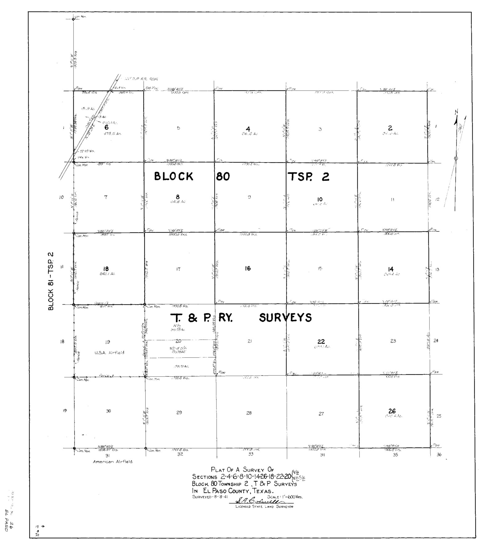
Plat of a Survey of Sections 2-4-6-8-10-14-26-18-22-20 Block 80 Township 2, T&P Surveys in El Paso County, Texas
-
Map/Doc
11457
-
Collection
General Map Collection
-
Object Dates
1941/4/25 (File Date)
1941/8/18 (Survey Date)
-
People and Organizations
S.A. Colwell (Surveyor/Engineer)
-
Counties
El Paso
-
Subjects
Surveying Sketch File
-
Height x Width
24.8 x 21.9 inches
63.0 x 55.6 cm
-
Medium
paper, photocopy
-
Scale
1:600
Part of: General Map Collection
Limestone County Working Sketch 15

Print $20.00
- Digital $50.00
Limestone County Working Sketch 15
1936
Size 14.7 x 16.3 inches
Map/Doc 70565
Brazoria County Working Sketch 47

Print $40.00
- Digital $50.00
Brazoria County Working Sketch 47
1988
Size 35.3 x 59.9 inches
Map/Doc 67532
Edwards County Working Sketch 53

Print $40.00
- Digital $50.00
Edwards County Working Sketch 53
1951
Size 40.8 x 48.5 inches
Map/Doc 68929
Menard County Working Sketch 30

Print $20.00
- Digital $50.00
Menard County Working Sketch 30
1974
Size 47.9 x 38.8 inches
Map/Doc 70977
Cameron County Rolled Sketch 10

Print $20.00
- Digital $50.00
Cameron County Rolled Sketch 10
Size 38.5 x 44.5 inches
Map/Doc 8566
Stonewall County Working Sketch 31

Print $20.00
- Digital $50.00
Stonewall County Working Sketch 31
1983
Size 42.6 x 42.9 inches
Map/Doc 62338
El Paso County Working Sketch 2

Print $20.00
- Digital $50.00
El Paso County Working Sketch 2
1913
Size 15.5 x 25.0 inches
Map/Doc 69024
Midland County Working Sketch 25

Print $40.00
- Digital $50.00
Midland County Working Sketch 25
1957
Size 58.3 x 49.1 inches
Map/Doc 71006

Montague County Working Sketch 3

Print $20.00
- Digital $50.00
Montague County Working Sketch 3
1912
Size 20.5 x 15.4 inches
Map/Doc 71069
Liberty County Working Sketch 14

Print $20.00
- Digital $50.00
Liberty County Working Sketch 14
1919
Size 17.0 x 25.4 inches
Map/Doc 70473
Galveston County Sketch File 6

Print $4.00
- Digital $50.00
Galveston County Sketch File 6
Size 14.2 x 8.9 inches
Map/Doc 23362
You may also like
The Coast & Bays of Western Texas, St. Joseph's and Mustang Islands from actual survey, the remainder from county maps, etc.

Print $20.00
- Digital $50.00
The Coast & Bays of Western Texas, St. Joseph's and Mustang Islands from actual survey, the remainder from county maps, etc.
1857
Size 28.0 x 18.3 inches
Map/Doc 72767
Brazoria County NRC Article 33.136 Sketch 18

Print $24.00
- Digital $50.00
Brazoria County NRC Article 33.136 Sketch 18
2015
Size 24.0 x 36.0 inches
Map/Doc 95066
Flight Mission No. CUG-3P, Frame 23, Kleberg County

Print $20.00
- Digital $50.00
Flight Mission No. CUG-3P, Frame 23, Kleberg County
1956
Size 18.5 x 22.3 inches
Map/Doc 86233
Flight Mission No. DCL-5C, Frame 71, Kenedy County

Print $20.00
- Digital $50.00
Flight Mission No. DCL-5C, Frame 71, Kenedy County
1943
Size 18.5 x 22.2 inches
Map/Doc 85854
Flight Mission No. CRC-3R, Frame 34, Chambers County

Print $20.00
- Digital $50.00
Flight Mission No. CRC-3R, Frame 34, Chambers County
1956
Size 18.5 x 22.3 inches
Map/Doc 84807
Flight Mission No. BRA-16M, Frame 110, Jefferson County

Print $20.00
- Digital $50.00
Flight Mission No. BRA-16M, Frame 110, Jefferson County
1953
Size 18.6 x 22.4 inches
Map/Doc 85720

Baylor County Sketch File 20

Print $8.00
- Digital $50.00
Baylor County Sketch File 20
1887
Size 12.9 x 8.2 inches
Map/Doc 14195
Matagorda County NRC Article 33.136 Sketch 17

Print $24.00
Matagorda County NRC Article 33.136 Sketch 17
2023
Map/Doc 97274
Maverick County Rolled Sketch 19

Print $20.00
- Digital $50.00
Maverick County Rolled Sketch 19
1955
Size 33.5 x 44.1 inches
Map/Doc 9494
Bowie County Sketch File 7e

Print $10.00
- Digital $50.00
Bowie County Sketch File 7e
1927
Size 10.5 x 8.4 inches
Map/Doc 14867
Topographical Map of the Rio Grande, Sheet No. 2

Print $20.00
- Digital $50.00
Topographical Map of the Rio Grande, Sheet No. 2
1912
Map/Doc 89526