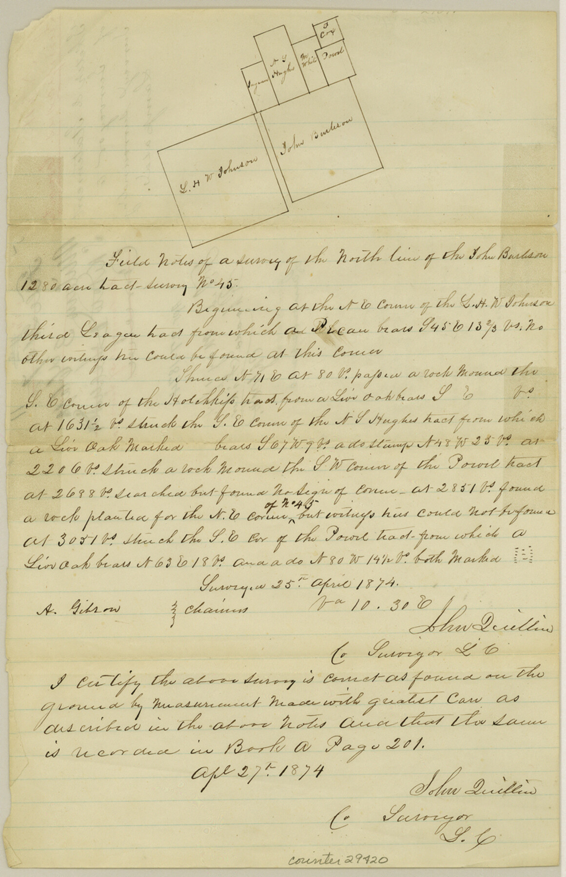
Lampasas County Sketch File 11
[Field notes of north line of John Burleson survey in the vicinity of Lampasas, the county seat]
-
Map/Doc
29420
-
Collection
General Map Collection
-
Object Dates
4/27/1874 (Creation Date)
5/1/1874 (File Date)
4/25/1874 (Survey Date)
-
People and Organizations
John Quillin (Surveyor/Engineer)
A. Gibson (Chainman)
-
Counties
Lampasas
-
Subjects
Surveying Sketch File
-
Height x Width
12.2 x 7.9 inches
31.0 x 20.1 cm
-
Medium
paper, manuscript
Part of: General Map Collection
Scarborough's Map of the New England States Vermont, New Hampshire, Maine, Massachusetts, Rhode Island and Connecticut

Print $40.00
- Digital $50.00
Scarborough's Map of the New England States Vermont, New Hampshire, Maine, Massachusetts, Rhode Island and Connecticut
1910
Size 58.3 x 40.1 inches
Map/Doc 97106
Flight Mission No. CRC-3R, Frame 19, Chambers County

Print $20.00
- Digital $50.00
Flight Mission No. CRC-3R, Frame 19, Chambers County
1956
Size 18.5 x 22.1 inches
Map/Doc 84793
Chambers County Sketch File B

Print $2.00
- Digital $50.00
Chambers County Sketch File B
1907
Size 7.2 x 8.5 inches
Map/Doc 17515
Burnet County Sketch File 24

Print $8.00
- Digital $50.00
Burnet County Sketch File 24
1872
Size 7.9 x 10.2 inches
Map/Doc 16721
Current Miscellaneous File 36

Print $12.00
- Digital $50.00
Current Miscellaneous File 36
Size 10.3 x 12.4 inches
Map/Doc 73952
Smith County Rolled Sketch 6A3

Print $40.00
- Digital $50.00
Smith County Rolled Sketch 6A3
1990
Size 48.6 x 36.8 inches
Map/Doc 10698
Map accompanying report of scout made by 2nd Lt. F. de I. Carrington. 1st Infantry

Print $20.00
- Digital $50.00
Map accompanying report of scout made by 2nd Lt. F. de I. Carrington. 1st Infantry
1881
Size 22.2 x 18.0 inches
Map/Doc 65407
Roberts County Working Sketch 46

Print $20.00
- Digital $50.00
Roberts County Working Sketch 46
1979
Size 19.4 x 28.3 inches
Map/Doc 63572
[Map of Block 97, Borden and Scurry Co (Exhibit A); Map of Southeastern part of Young Territory; Map of part of of Borden, Fisher, Kent, Mitchell, Scurry and Garza Cos. Showing the north boundary line of the T&P 80 mile reservation]
![65692, [Map of Block 97, Borden and Scurry Co (Exhibit A); Map of Southeastern part of Young Territory; Map of part of of Borden, Fisher, Kent, Mitchell, Scurry and Garza Cos. Showing the north boundary line of the T&P 80 mile reservation], General Map Collection](https://historictexasmaps.com/wmedia_w700/maps/65692-1.tif.jpg)
Print $20.00
- Digital $50.00
[Map of Block 97, Borden and Scurry Co (Exhibit A); Map of Southeastern part of Young Territory; Map of part of of Borden, Fisher, Kent, Mitchell, Scurry and Garza Cos. Showing the north boundary line of the T&P 80 mile reservation]
1873
Size 33.4 x 29.6 inches
Map/Doc 65692
Knox County Rolled Sketch 24

Print $20.00
- Digital $50.00
Knox County Rolled Sketch 24
2007
Size 28.5 x 34.5 inches
Map/Doc 87722
Culberson County Rolled Sketch 41

Print $88.00
- Digital $50.00
Culberson County Rolled Sketch 41
1944
Size 57.5 x 46.0 inches
Map/Doc 8752
Map of Collin County

Print $20.00
- Digital $50.00
Map of Collin County
1862
Size 24.4 x 20.5 inches
Map/Doc 1084
You may also like
Menard County Boundary File 4

Print $12.00
- Digital $50.00
Menard County Boundary File 4
Size 10.9 x 8.6 inches
Map/Doc 57076
Matagorda Light to Aransas Pass

Print $20.00
- Digital $50.00
Matagorda Light to Aransas Pass
1946
Size 35.8 x 44.5 inches
Map/Doc 73394
Gulf Intracoastal Waterway, Tex. - Aransas Bay to Corpus Christi Bay - Modified Route of Main Channel/Dredging

Print $20.00
- Digital $50.00
Gulf Intracoastal Waterway, Tex. - Aransas Bay to Corpus Christi Bay - Modified Route of Main Channel/Dredging
1958
Size 31.3 x 42.6 inches
Map/Doc 61894
[Sketch of Part of B. S. & F. Block 9]
![93090, [Sketch of Part of B. S. & F. Block 9], Twichell Survey Records](https://historictexasmaps.com/wmedia_w700/maps/93090-1.tif.jpg)
Print $2.00
- Digital $50.00
[Sketch of Part of B. S. & F. Block 9]
Size 7.6 x 7.4 inches
Map/Doc 93090
Map of the Western Part of Bexar District

Print $40.00
- Digital $50.00
Map of the Western Part of Bexar District
1849
Size 64.0 x 54.3 inches
Map/Doc 16944
New Guide to Spanish and Mexican Land Grants in South Texas

Price $15.00
New Guide to Spanish and Mexican Land Grants in South Texas
2009
Size 11.0 x 8.5 inches
Map/Doc 83388
The Chief Justice County of Sabine. Undated

Print $20.00
The Chief Justice County of Sabine. Undated
2020
Size 20.0 x 21.7 inches
Map/Doc 96068
Wilson County Sketch File 13

Print $4.00
- Digital $50.00
Wilson County Sketch File 13
1873
Size 10.2 x 8.0 inches
Map/Doc 40429
Montague County Working Sketch 14

Print $20.00
- Digital $50.00
Montague County Working Sketch 14
1940
Size 28.4 x 17.9 inches
Map/Doc 71080
Gonzales County

Print $40.00
- Digital $50.00
Gonzales County
1920
Size 41.0 x 51.2 inches
Map/Doc 1841
Edwards County Working Sketch 118

Print $20.00
- Digital $50.00
Edwards County Working Sketch 118
1974
Size 19.5 x 30.4 inches
Map/Doc 68994
Val Verde County Working Sketch 42

Print $20.00
- Digital $50.00
Val Verde County Working Sketch 42
1944
Size 24.4 x 33.9 inches
Map/Doc 72177