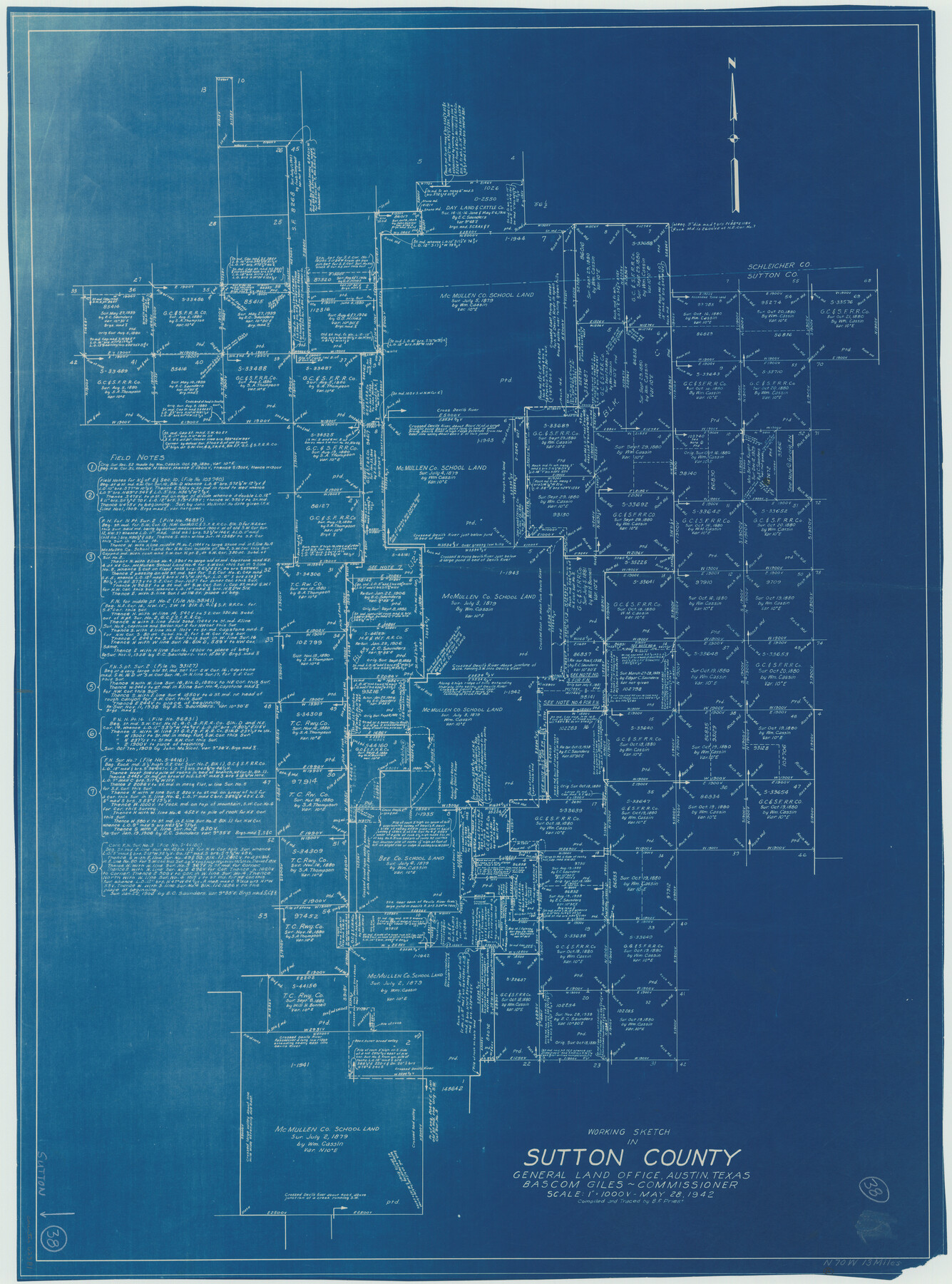
Sutton County Working Sketch 38
-
Map/Doc
62381
-
Collection
General Map Collection
-
Object Dates
5/28/1942 (Creation Date)
-
People and Organizations
B.F. Priest (Draftsman)
-
Counties
Sutton
-
Subjects
Surveying Working Sketch
-
Height x Width
35.2 x 26.1 inches
89.4 x 66.3 cm
-
Scale
1" = 1000 varas
Part of: General Map Collection
Jackson County Working Sketch 8

Print $20.00
- Digital $50.00
Jackson County Working Sketch 8
1980
Size 30.4 x 29.0 inches
Map/Doc 66456
Motley County Working Sketch 3

Print $20.00
- Digital $50.00
Motley County Working Sketch 3
1914
Size 13.2 x 20.4 inches
Map/Doc 71208
Flight Mission No. CUG-3P, Frame 142, Kleberg County

Print $20.00
- Digital $50.00
Flight Mission No. CUG-3P, Frame 142, Kleberg County
1956
Size 18.7 x 22.3 inches
Map/Doc 86277
Young County Sketch File 10b

Print $4.00
- Digital $50.00
Young County Sketch File 10b
1880
Size 12.9 x 8.4 inches
Map/Doc 40870
Kleberg County, Cayo del Grullo

Print $20.00
- Digital $50.00
Kleberg County, Cayo del Grullo
1952
Size 32.6 x 29.0 inches
Map/Doc 73506
Gray County Sketch File 11

Print $40.00
- Digital $50.00
Gray County Sketch File 11
Size 15.0 x 13.5 inches
Map/Doc 24452
Blanco County Sketch File 36

Print $8.00
- Digital $50.00
Blanco County Sketch File 36
1889
Size 11.2 x 8.8 inches
Map/Doc 14642
Childress County Working Sketch 4

Print $20.00
- Digital $50.00
Childress County Working Sketch 4
1939
Size 43.4 x 14.5 inches
Map/Doc 68020
Panola County Working Sketch 8

Print $20.00
- Digital $50.00
Panola County Working Sketch 8
1943
Map/Doc 71417
Trinity River, Map of J. B. Bradley's Levee in Valley of Cummins Creek about 2 1/2 Miles South of Rice Showing Proposed Change of Location

Print $2.00
- Digital $50.00
Trinity River, Map of J. B. Bradley's Levee in Valley of Cummins Creek about 2 1/2 Miles South of Rice Showing Proposed Change of Location
1950
Size 13.9 x 16.1 inches
Map/Doc 65246
Flight Mission No. DQN-6K, Frame 17, Calhoun County

Print $20.00
- Digital $50.00
Flight Mission No. DQN-6K, Frame 17, Calhoun County
1953
Size 18.5 x 22.1 inches
Map/Doc 84439
El Paso County Rolled Sketch 8

Print $40.00
- Digital $50.00
El Paso County Rolled Sketch 8
1882
Size 39.9 x 51.7 inches
Map/Doc 8852
You may also like
The Rand McNally New Commercial Atlas Map of Texas

Print $20.00
- Digital $50.00
The Rand McNally New Commercial Atlas Map of Texas
1915
Size 28.5 x 40.3 inches
Map/Doc 95862

Swisher County Sketch File 1b

Print $8.00
- Digital $50.00
Swisher County Sketch File 1b
1884
Size 12.8 x 8.2 inches
Map/Doc 37570
Bexar County Working Sketch 20

Print $20.00
- Digital $50.00
Bexar County Working Sketch 20
1982
Size 42.4 x 43.6 inches
Map/Doc 67336
Harris County Rolled Sketch 80B

Print $20.00
- Digital $50.00
Harris County Rolled Sketch 80B
Size 32.0 x 44.2 inches
Map/Doc 9137
Reagan County Working Sketch 16

Print $20.00
- Digital $50.00
Reagan County Working Sketch 16
1950
Size 24.5 x 42.5 inches
Map/Doc 71858
Karnes County Rolled Sketch 1

Print $20.00
- Digital $50.00
Karnes County Rolled Sketch 1
1943
Size 27.5 x 25.7 inches
Map/Doc 6452
Bell County Rolled Sketch 1

Print $20.00
- Digital $50.00
Bell County Rolled Sketch 1
1954
Size 38.1 x 41.1 inches
Map/Doc 75938
Maps & Lists Showing Prison Lands (Oil & Gas) Leased as of June 1955

Digital $50.00
Maps & Lists Showing Prison Lands (Oil & Gas) Leased as of June 1955
Size 11.2 x 8.7 inches
Map/Doc 62871
Hutchinson County Working Sketch 30

Print $20.00
- Digital $50.00
Hutchinson County Working Sketch 30
1978
Size 27.6 x 23.3 inches
Map/Doc 66390
Texas-Indian Territory Gainesville Quadrangle

Print $20.00
- Digital $50.00
Texas-Indian Territory Gainesville Quadrangle
1913
Size 20.4 x 16.9 inches
Map/Doc 75103
Midland County, Texas

Print $20.00
- Digital $50.00
Midland County, Texas
1880
Size 20.8 x 17.7 inches
Map/Doc 437