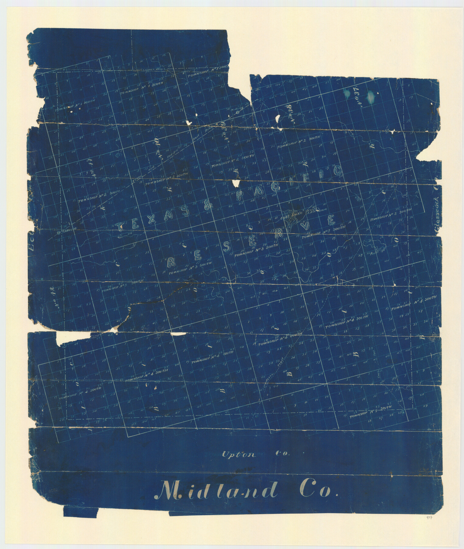
Midland County, Texas
- 
                          Map/Doc
437
 - 
                            Collection
Maddox Collection
 - 
                            Object Dates
[1880 ca.] (Creation Date)
 - 
                            People and Organizations
General Land Office (Publisher)
 - 
                            Counties
Midland
 - 
                            Subjects
County
 - 
                            Height x Width
20.8 x 17.7 inches
52.8 x 45.0 cm
 - 
                            Medium
blueprint/diazo
 - 
                            Comments
Copy of lithograph. Conservation funded in 2011.
 - 
                            Features
Midway
T&P
Salt Lake
Odessa
Pecks Spr[ing]
Fort Concho Trail
Shafters Trail
 
Part of: Maddox Collection
            Palo Pinto County, Texas


                                            Print $20.00                    
                                             -                         Digital $50.00                                    
                Palo Pinto County, Texas
1871
Size 28.8 x 23.4 inches
                                Map/Doc 660
            
            Map of Rockport Texas, Aransas County


                                            Print $20.00                    
                                             -                         Digital $50.00                                    
                Map of Rockport Texas, Aransas County
1888
Size 29.0 x 20.5 inches
                                Map/Doc 380
            
            Map of Duval County, Texas


                                            Print $20.00                    
                                             -                         Digital $50.00                                    
                Map of Duval County, Texas
1880
Size 29.8 x 22.6 inches
                                Map/Doc 712
            
            Map of Swisher Addition


                                            Print $20.00                    
                                             -                         Digital $50.00                                    
                Map of Swisher Addition
1910
Size 18.0 x 13.1 inches
                                Map/Doc 83425
            
            Copy of Sketch in Nacogdoches Scrip 1392


                                            Print $20.00                    
                                             -                         Digital $50.00                                    
                Copy of Sketch in Nacogdoches Scrip 1392
1890
Size 25.3 x 14.7 inches
                                Map/Doc 75780
            
            Map of Wood County, Texas


                                            Print $20.00                    
                                             -                         Digital $50.00                                    
                Map of Wood County, Texas
1879
Size 17.5 x 17.1 inches
                                Map/Doc 659
            
            Subdivision for R.N. Graham


                                            Print $3.00                    
                                             -                         Digital $50.00                                    
                Subdivision for R.N. Graham
1913
Size 15.2 x 10.4 inches
                                Map/Doc 83430
            
            Map of SW portion of Hale Co., Texas


                                            Print $3.00                    
                                             -                         Digital $50.00                                    
                Map of SW portion of Hale Co., Texas
Size 12.7 x 10.8 inches
                                Map/Doc 518
            
            Sketch No. 1, Dickens & Motley Cos.


                                            Print $20.00                    
                                             -                         Digital $50.00                                    
                Sketch No. 1, Dickens & Motley Cos.
1879
Size 17.9 x 15.5 inches
                                Map/Doc 10761
            
            Map Representing the Original Locations of Various Surveys Deliniated Thereon


                                            Print $40.00                    
                                             -                         Digital $50.00                                    
                Map Representing the Original Locations of Various Surveys Deliniated Thereon
1890
Size 40.8 x 62.0 inches
                                Map/Doc 469
            
            Plat of surveys in El Paso Co. made for Maddox Bro's & Anderson and Gunter & Munson


                                            Print $20.00                    
                                             -                         Digital $50.00                                    
                Plat of surveys in El Paso Co. made for Maddox Bro's & Anderson and Gunter & Munson
Size 22.2 x 23.4 inches
                                Map/Doc 713
            
            Map of the San Antonio del Encinal as Corrected


                                            Print $20.00                    
                                             -                         Digital $50.00                                    
                Map of the San Antonio del Encinal as Corrected
1916
Size 28.5 x 30.6 inches
                                Map/Doc 4456
            You may also like
            Reeves County Sketch File 1


                                            Print $10.00                    
                                             -                         Digital $50.00                                    
                Reeves County Sketch File 1
Size 9.0 x 15.8 inches
                                Map/Doc 35176
            
            Crosby County Working Sketch 4


                                            Print $20.00                    
                                             -                         Digital $50.00                                    
                Crosby County Working Sketch 4
1907
Size 19.9 x 14.0 inches
                                Map/Doc 68438
            
            Map of the United States to accompany Granger's Southern and Western Texas Guide


                                            Print $20.00                    
                                             -                         Digital $50.00                                    
                Map of the United States to accompany Granger's Southern and Western Texas Guide
1878
Size 26.7 x 20.9 inches
                                Map/Doc 96613
            
            Crockett County Rolled Sketch 53


                                            Print $20.00                    
                                             -                         Digital $50.00                                    
                Crockett County Rolled Sketch 53
1942
Size 17.5 x 36.8 inches
                                Map/Doc 5598
            
            Goliad County Sketch File 10


                                            Print $4.00                    
                                             -                         Digital $50.00                                    
                Goliad County Sketch File 10
1859
Size 9.3 x 8.1 inches
                                Map/Doc 24226
            
            Bexar County Boundary File 2


                                            Print $32.00                    
                                             -                         Digital $50.00                                    
                Bexar County Boundary File 2
Size 8.4 x 4.0 inches
                                Map/Doc 50518
            
            Boundary Between the United States & Mexico Agreed upon by the Joint Commission under the Treaty of Guadalupe Hidalgo


                                            Print $20.00                    
                                             -                         Digital $50.00                                    
                Boundary Between the United States & Mexico Agreed upon by the Joint Commission under the Treaty of Guadalupe Hidalgo
1853
Size 18.4 x 26.5 inches
                                Map/Doc 72884
            
            Maps & Lists Showing Prison Lands (Oil & Gas) Leased as of June 1955


                                                                    Digital $50.00                                    
                Maps & Lists Showing Prison Lands (Oil & Gas) Leased as of June 1955
Size 11.1 x 8.8 inches
                                Map/Doc 62873
            
            Orange County Working Sketch 26


                                            Print $20.00                    
                                             -                         Digital $50.00                                    
                Orange County Working Sketch 26
1953
Size 13.4 x 22.0 inches
                                Map/Doc 71358
            
            Coast Chart No. 210 - Aransas Pass and Corpus Christi Bay with the coast to latitude 27° 12', Texas


                                            Print $20.00                    
                                             -                         Digital $50.00                                    
                Coast Chart No. 210 - Aransas Pass and Corpus Christi Bay with the coast to latitude 27° 12', Texas
1907
Size 44.2 x 36.5 inches
                                Map/Doc 73449
            
            Uvalde County Sketch File 8


                                            Print $6.00                    
                                             -                         Digital $50.00                                    
                Uvalde County Sketch File 8
1882
Size 8.4 x 6.2 inches
                                Map/Doc 38964
            
            Val Verde County Working Sketch Graphic Index, Sheet 3 (Sketches 89 to Most Recent)


                                            Print $20.00                    
                                             -                         Digital $50.00                                    
                Val Verde County Working Sketch Graphic Index, Sheet 3 (Sketches 89 to Most Recent)
1944
Size 40.3 x 36.6 inches
                                Map/Doc 76726