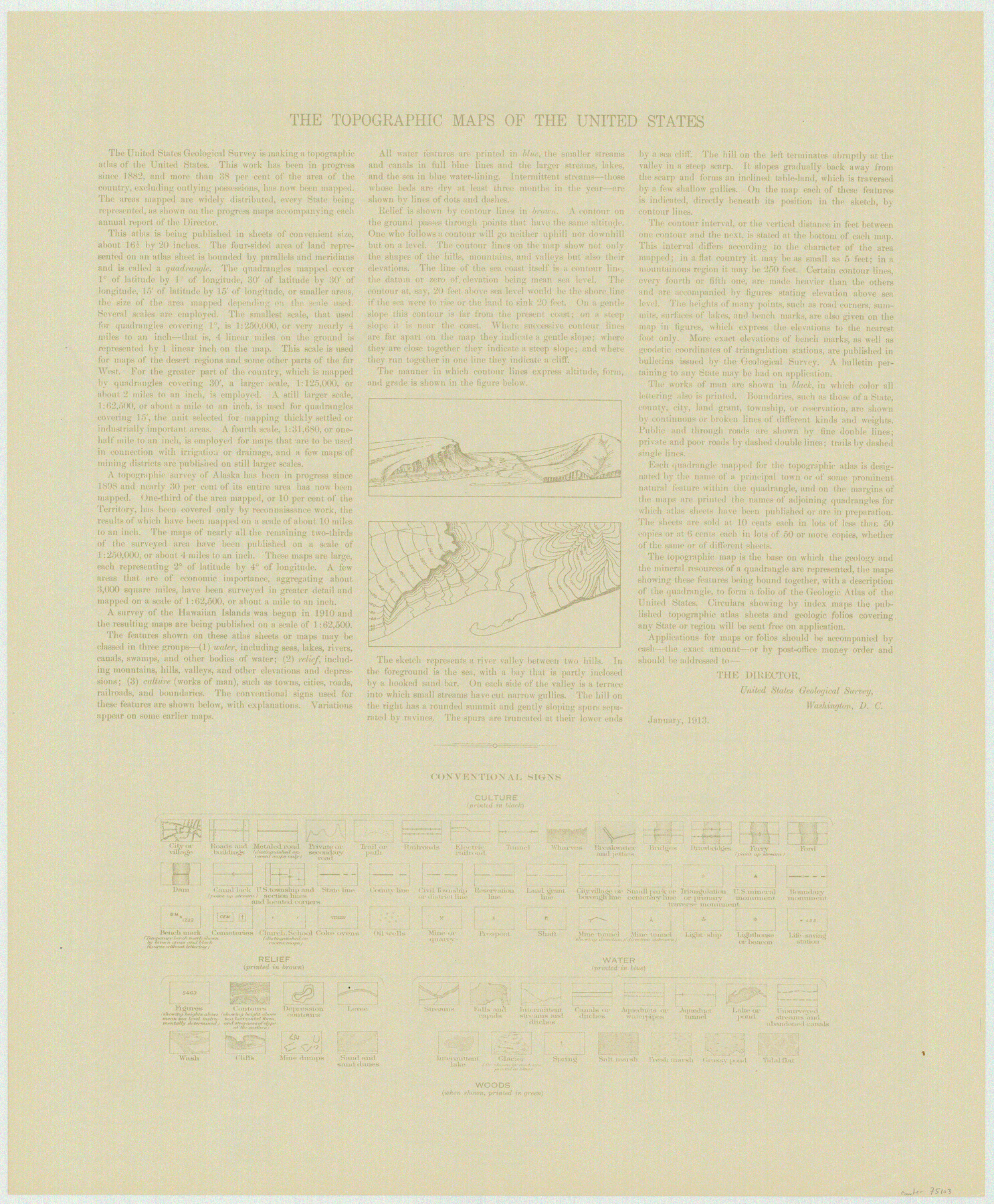
Texas-Indian Territory Gainesville Quadrangle
-
Map/Doc
75103
-
Collection
General Map Collection
-
Object Dates
1913 (Creation Date)
-
Subjects
Texas Boundaries Topographic
-
Height x Width
20.4 x 16.9 inches
51.8 x 42.9 cm
-
Comments
dual-sided map
Part of: General Map Collection
Bexar County Sketch File 21

Print $4.00
- Digital $50.00
Bexar County Sketch File 21
1859
Size 12.2 x 7.9 inches
Map/Doc 14484
PSL Field Notes for Blocks C38 and C39 in Dawson and Terry Counties, and Block C41 in Dawson, Lynn, and Terry Counties

PSL Field Notes for Blocks C38 and C39 in Dawson and Terry Counties, and Block C41 in Dawson, Lynn, and Terry Counties
Map/Doc 81650
Map of Retrieve Plantation, Brazoria County, Texas

Print $20.00
- Digital $50.00
Map of Retrieve Plantation, Brazoria County, Texas
Size 16.9 x 16.4 inches
Map/Doc 63000
San Antonio & Surrounding Area

San Antonio & Surrounding Area
1997
Size 36.4 x 46.3 inches
Map/Doc 96867
[Sketch for Mineral Application 24072, San Jacinto River]
![65608, [Sketch for Mineral Application 24072, San Jacinto River], General Map Collection](https://historictexasmaps.com/wmedia_w700/maps/65608.tif.jpg)
Print $20.00
- Digital $50.00
[Sketch for Mineral Application 24072, San Jacinto River]
1929
Size 8.6 x 14.0 inches
Map/Doc 65608
Jack County Working Sketch 20

Print $20.00
- Digital $50.00
Jack County Working Sketch 20
1991
Size 35.4 x 28.9 inches
Map/Doc 66446
Maps of Gulf Intracoastal Waterway, Texas - Sabine River to the Rio Grande and connecting waterways including ship channels

Print $20.00
- Digital $50.00
Maps of Gulf Intracoastal Waterway, Texas - Sabine River to the Rio Grande and connecting waterways including ship channels
1966
Size 14.5 x 22.2 inches
Map/Doc 61931
Jasper County Working Sketch 33

Print $20.00
- Digital $50.00
Jasper County Working Sketch 33
1999
Size 30.4 x 17.5 inches
Map/Doc 66495
Lubbock County Sketch File 14

Print $4.00
- Digital $50.00
Lubbock County Sketch File 14
1892
Size 11.2 x 8.9 inches
Map/Doc 30438
Cass County Rolled Sketch 5B

Print $20.00
- Digital $50.00
Cass County Rolled Sketch 5B
1949
Size 23.5 x 16.4 inches
Map/Doc 5412
Map of the Mississippi River from its Source to the Mouth of the Missouri

Print $20.00
- Digital $50.00
Map of the Mississippi River from its Source to the Mouth of the Missouri
1810
Size 10.4 x 31.3 inches
Map/Doc 95153
Cameron County Rolled Sketch 34

Print $20.00
- Digital $50.00
Cameron County Rolled Sketch 34
2000
Size 24.2 x 35.2 inches
Map/Doc 5397
You may also like
Navarro County Sketch File 7

Print $4.00
- Digital $50.00
Navarro County Sketch File 7
1854
Size 12.2 x 8.0 inches
Map/Doc 32313
Brewster County Working Sketch 88

Print $20.00
- Digital $50.00
Brewster County Working Sketch 88
1973
Size 45.2 x 39.6 inches
Map/Doc 67688
Flight Mission No. CRC-6R, Frame 12, Chambers County

Print $20.00
- Digital $50.00
Flight Mission No. CRC-6R, Frame 12, Chambers County
1956
Size 18.7 x 22.3 inches
Map/Doc 84966
Harris County Historic Topographic 11

Print $20.00
- Digital $50.00
Harris County Historic Topographic 11
1915
Size 29.2 x 22.6 inches
Map/Doc 65821
General Highway Map, Starr County, Texas

Print $20.00
General Highway Map, Starr County, Texas
1961
Size 24.9 x 18.1 inches
Map/Doc 79658
[Leagues 701-714 and vicinity]
![90460, [Leagues 701-714 and vicinity], Twichell Survey Records](https://historictexasmaps.com/wmedia_w700/maps/90460-1.tif.jpg)
Print $20.00
- Digital $50.00
[Leagues 701-714 and vicinity]
Size 37.7 x 22.8 inches
Map/Doc 90460
Township No. 2 South Range No. 19 West of the Indian Meridian

Print $20.00
- Digital $50.00
Township No. 2 South Range No. 19 West of the Indian Meridian
1875
Size 19.2 x 24.8 inches
Map/Doc 75181
Flight Mission No. DQO-8K, Frame 18, Galveston County

Print $20.00
- Digital $50.00
Flight Mission No. DQO-8K, Frame 18, Galveston County
1952
Size 18.6 x 22.4 inches
Map/Doc 85141
Frio County Sketch File 1

Print $8.00
- Digital $50.00
Frio County Sketch File 1
1848
Size 8.6 x 7.7 inches
Map/Doc 23101
[Right of Way Map, Belton Branch of the M.K.&T. RR.]
![64225, [Right of Way Map, Belton Branch of the M.K.&T. RR.], General Map Collection](https://historictexasmaps.com/wmedia_w700/maps/64225.tif.jpg)
Print $20.00
- Digital $50.00
[Right of Way Map, Belton Branch of the M.K.&T. RR.]
1896
Size 7.2 x 21.6 inches
Map/Doc 64225
Map of Texas to accompany Granger's Southern and Western Texas Guide

Print $20.00
- Digital $50.00
Map of Texas to accompany Granger's Southern and Western Texas Guide
1878
Size 26.7 x 20.8 inches
Map/Doc 96612
Coke County Rolled Sketch 14A

Print $20.00
- Digital $50.00
Coke County Rolled Sketch 14A
Size 21.0 x 14.1 inches
Map/Doc 5515