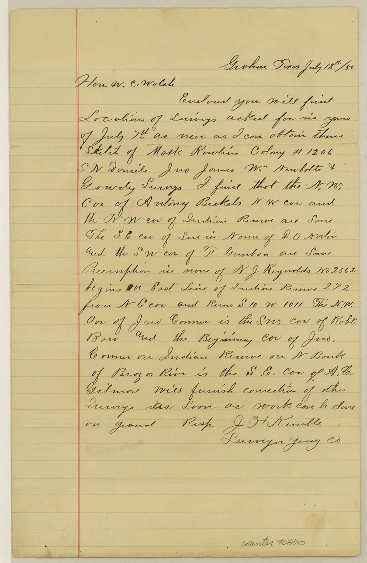
Young County Sketch File 10b
[Letter regarding surveys in Young County]
-
Map/Doc
40870
-
Collection
General Map Collection
-
Object Dates
1880/7/18 (Creation Date)
1880/7/18 (Creation Date)
-
People and Organizations
J.H. Kemble (Surveyor/Engineer)
-
Counties
Young
-
Subjects
Surveying Sketch File
-
Height x Width
12.9 x 8.4 inches
32.8 x 21.3 cm
-
Medium
paper, manuscript
-
Features
Indian Reserve
Brazos River
Part of: General Map Collection
Houston County Sketch File 37

Print $6.00
- Digital $50.00
Houston County Sketch File 37
1846
Size 12.8 x 7.8 inches
Map/Doc 26819
Terrell County Sketch File 27

Print $10.00
- Digital $50.00
Terrell County Sketch File 27
1936
Size 8.7 x 11.3 inches
Map/Doc 37971
Medina County Sketch File 6

Print $22.00
- Digital $50.00
Medina County Sketch File 6
1874
Size 8.4 x 12.0 inches
Map/Doc 31454
Upton County Sketch File 5

Print $40.00
- Digital $50.00
Upton County Sketch File 5
Size 8.7 x 24.4 inches
Map/Doc 38813
Montague County Sketch File 22

Print $20.00
- Digital $50.00
Montague County Sketch File 22
1927
Size 27.7 x 20.1 inches
Map/Doc 12107
Parker County Sketch File 31

Print $6.00
- Digital $50.00
Parker County Sketch File 31
1877
Size 9.9 x 9.8 inches
Map/Doc 33572
Martin County Sketch File 5

Print $4.00
- Digital $50.00
Martin County Sketch File 5
1913
Size 11.4 x 8.7 inches
Map/Doc 30640
Treaty to Resolve Pending Boundary Differences and Maintain the Rio Grande and Colorado River as the International Boundary Between the United States of American and Mexico

Print $4.00
- Digital $50.00
Treaty to Resolve Pending Boundary Differences and Maintain the Rio Grande and Colorado River as the International Boundary Between the United States of American and Mexico
1970
Size 12.2 x 19.0 inches
Map/Doc 83100
Railroad Track Map, H&TCRRCo., Falls County, Texas

Print $4.00
- Digital $50.00
Railroad Track Map, H&TCRRCo., Falls County, Texas
1918
Size 11.8 x 18.6 inches
Map/Doc 62844
Clarkson's City Map of Port Aransas

Print $20.00
- Digital $50.00
Clarkson's City Map of Port Aransas
Size 18.5 x 26.7 inches
Map/Doc 3038
Crockett County Rolled Sketch 39
Print $20.00
- Digital $50.00
Crockett County Rolled Sketch 39
1935
Size 30.3 x 43.0 inches
Map/Doc 8705
Map of Brazoria

Print $20.00
- Digital $50.00
Map of Brazoria
1863
Size 27.4 x 27.3 inches
Map/Doc 1013
You may also like
Trinity County Working Sketch 3

Print $20.00
- Digital $50.00
Trinity County Working Sketch 3
1905
Size 26.7 x 19.2 inches
Map/Doc 69451
Jefferson County Rolled Sketch 61G

Print $20.00
- Digital $50.00
Jefferson County Rolled Sketch 61G
1928
Size 27.2 x 40.3 inches
Map/Doc 6416
Harris County Working Sketch 76

Print $20.00
- Digital $50.00
Harris County Working Sketch 76
1966
Size 32.2 x 24.2 inches
Map/Doc 65968
General Highway Map, Brazos County, Texas

Print $20.00
General Highway Map, Brazos County, Texas
1940
Size 25.2 x 18.5 inches
Map/Doc 79026
Flight Mission No. BRA-17M, Frame 15, Jefferson County

Print $20.00
- Digital $50.00
Flight Mission No. BRA-17M, Frame 15, Jefferson County
1953
Size 18.5 x 22.3 inches
Map/Doc 85796
Property Line Map, Housing Authority of the City of Lubbock, Texas

Print $20.00
- Digital $50.00
Property Line Map, Housing Authority of the City of Lubbock, Texas
1946
Size 19.4 x 25.4 inches
Map/Doc 92777
Travis County Boundary File 31

Print $4.00
- Digital $50.00
Travis County Boundary File 31
Size 10.0 x 8.2 inches
Map/Doc 59471
Brewster County Sketch File N-2

Print $44.00
- Digital $50.00
Brewster County Sketch File N-2
1881
Size 8.2 x 12.8 inches
Map/Doc 15567
[Blocks 34-36, Township 2N]
![92027, [Blocks 34-36, Township 2N], Twichell Survey Records](https://historictexasmaps.com/wmedia_w700/maps/92027-1.tif.jpg)
Print $20.00
- Digital $50.00
[Blocks 34-36, Township 2N]
Size 36.8 x 24.2 inches
Map/Doc 92027
Fort Bend County Sketch File 3

Print $4.00
- Digital $50.00
Fort Bend County Sketch File 3
Size 12.8 x 8.1 inches
Map/Doc 22880
Collin County Working Sketch 5

Print $20.00
- Digital $50.00
Collin County Working Sketch 5
1992
Size 14.2 x 19.7 inches
Map/Doc 68099
Motley County Working Sketch 11

Print $20.00
- Digital $50.00
Motley County Working Sketch 11
1989
Size 28.5 x 33.0 inches
Map/Doc 71216