Hockley County Rolled Sketch 9
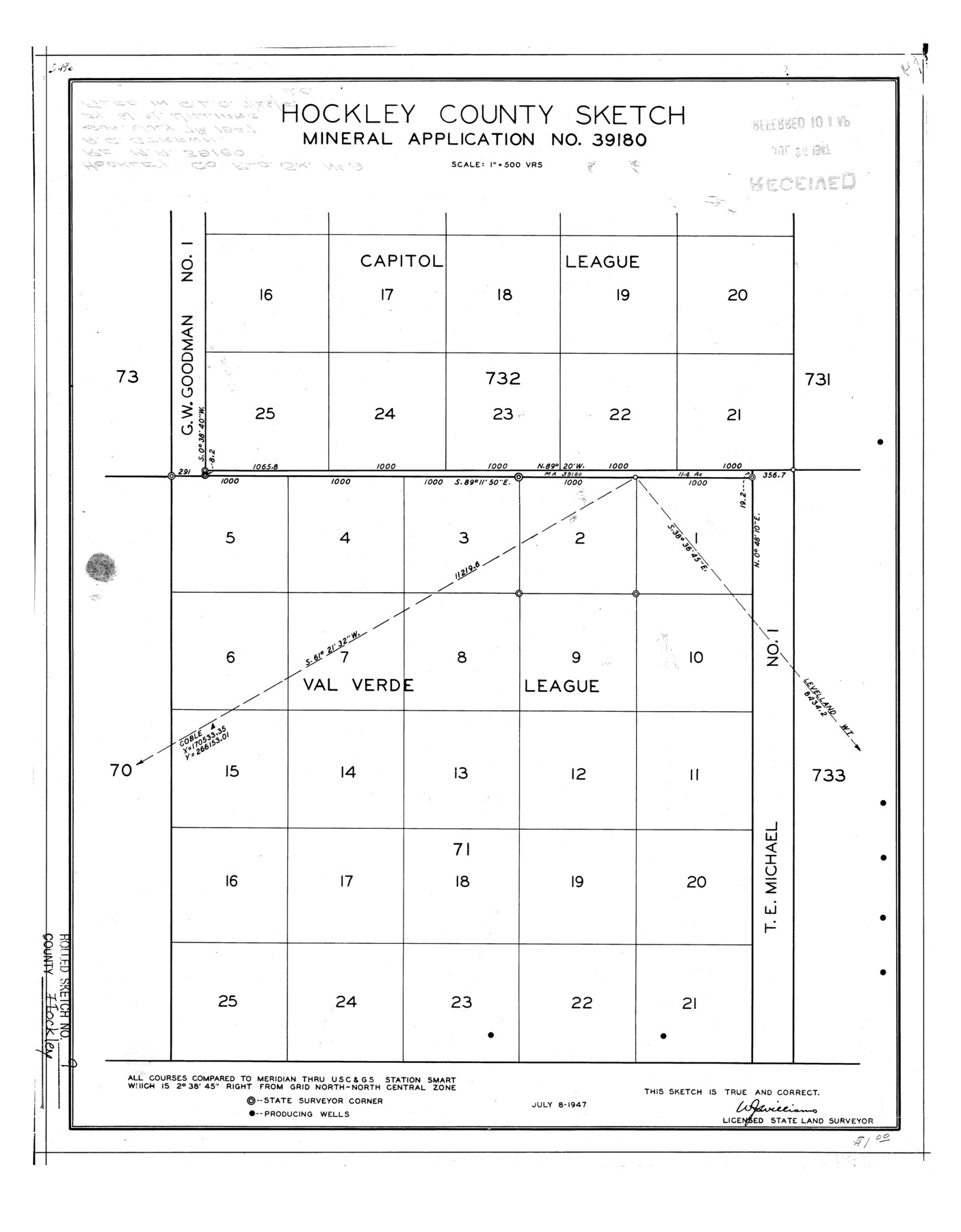
Hockley County Sketch - Mineral Application No. 39180
-
Map/Doc
6218
-
Collection
General Map Collection
-
Object Dates
1947/7/8 (Creation Date)
1947/7/26 (File Date)
-
People and Organizations
W.J. Williams (Surveyor/Engineer)
-
Counties
Hockley
-
Subjects
Surveying Rolled Sketch
-
Height x Width
21.2 x 16.5 inches
53.8 x 41.9 cm
-
Scale
1" = 500 varas
Part of: General Map Collection
Cooke County Rolled Sketch 7

Print $20.00
- Digital $50.00
Cooke County Rolled Sketch 7
2002
Size 44.8 x 34.9 inches
Map/Doc 77525
Real County Sketch File 10

Print $6.00
- Digital $50.00
Real County Sketch File 10
1932
Size 10.3 x 15.0 inches
Map/Doc 35063
Hudspeth County Rolled Sketch 57

Print $20.00
- Digital $50.00
Hudspeth County Rolled Sketch 57
Size 38.3 x 46.0 inches
Map/Doc 9223
Angelina County Sketch File 16a

Print $62.00
- Digital $50.00
Angelina County Sketch File 16a
1862
Size 6.0 x 8.3 inches
Map/Doc 13009
McMullen County Working Sketch 3

Print $20.00
- Digital $50.00
McMullen County Working Sketch 3
1922
Size 21.1 x 10.8 inches
Map/Doc 70704
Real County Working Sketch 7

Print $20.00
- Digital $50.00
Real County Working Sketch 7
1928
Size 18.4 x 19.4 inches
Map/Doc 71899
Morris County Rolled Sketch 2A

Print $20.00
- Digital $50.00
Morris County Rolled Sketch 2A
Size 24.0 x 18.7 inches
Map/Doc 10260
Flight Mission No. CRE-2R, Frame 90, Jackson County

Print $20.00
- Digital $50.00
Flight Mission No. CRE-2R, Frame 90, Jackson County
1956
Size 16.0 x 15.8 inches
Map/Doc 85362
Crane County Rolled Sketch 26

Print $20.00
- Digital $50.00
Crane County Rolled Sketch 26
2020
Size 36.5 x 24.5 inches
Map/Doc 96432

Map of South America engraved to illustrate Mitchell's new intermediate geography

Print $20.00
- Digital $50.00
Map of South America engraved to illustrate Mitchell's new intermediate geography
1885
Size 12.2 x 9.0 inches
Map/Doc 93525
Presidio County Rolled Sketch S2

Print $20.00
- Digital $50.00
Presidio County Rolled Sketch S2
1916
Size 14.2 x 12.0 inches
Map/Doc 7415
You may also like
Flight Mission No. DQN-7K, Frame 34, Calhoun County

Print $20.00
- Digital $50.00
Flight Mission No. DQN-7K, Frame 34, Calhoun County
1953
Size 18.5 x 22.1 inches
Map/Doc 84472
Young County Rolled Sketch 8

Print $20.00
- Digital $50.00
Young County Rolled Sketch 8
Size 40.5 x 25.8 inches
Map/Doc 8296
East Part El Paso County

Print $20.00
- Digital $50.00
East Part El Paso County
1908
Size 47.6 x 40.9 inches
Map/Doc 66814
Stephens County Sketch File 3

Print $4.00
- Digital $50.00
Stephens County Sketch File 3
Size 8.6 x 10.6 inches
Map/Doc 37015
Tarrant County State Real Property Sketch 2

Print $20.00
- Digital $50.00
Tarrant County State Real Property Sketch 2
1994
Size 21.3 x 27.6 inches
Map/Doc 61668
Reeves County Sketch File 11

Print $20.00
- Digital $50.00
Reeves County Sketch File 11
1891
Size 20.1 x 17.9 inches
Map/Doc 12245
Jasper County Sketch File 6

Print $26.00
- Digital $50.00
Jasper County Sketch File 6
1867
Size 12.8 x 8.2 inches
Map/Doc 27771
Newton County Sketch File 45

Print $12.00
- Digital $50.00
Newton County Sketch File 45
1957
Size 14.1 x 8.7 inches
Map/Doc 32445
[Reconnaissance report of Lieut. Scariott around Laguna del Madre and up to Fort San Saba]
![73006, [Reconnaissance report of Lieut. Scariott around Laguna del Madre and up to Fort San Saba], General Map Collection](https://historictexasmaps.com/wmedia_w700/maps/73006.tif.jpg)
Print $20.00
- Digital $50.00
[Reconnaissance report of Lieut. Scariott around Laguna del Madre and up to Fort San Saba]
Size 25.2 x 18.2 inches
Map/Doc 73006
Upton County Working Sketch 13

Print $20.00
- Digital $50.00
Upton County Working Sketch 13
1937
Size 22.6 x 43.4 inches
Map/Doc 69509
Webb County Sketch File 63

Print $20.00
- Digital $50.00
Webb County Sketch File 63
1947
Size 17.2 x 21.2 inches
Map/Doc 12653
Young County Rolled Sketch 18

Print $20.00
- Digital $50.00
Young County Rolled Sketch 18
2020
Size 22.6 x 30.4 inches
Map/Doc 95960