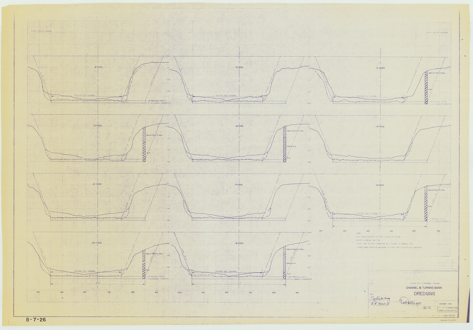
Texas City Channel, Texas, Channel and Turning Basin Dredging - Sheet 3
B-7-26
-
Map/Doc
61833
-
Collection
General Map Collection
-
Object Dates
1958 (Creation Date)
-
Subjects
Intracoastal Waterways
-
Height x Width
28.4 x 40.6 inches
72.1 x 103.1 cm
Part of: General Map Collection
Travis County Sketch File 12

Print $4.00
- Digital $50.00
Travis County Sketch File 12
1850
Size 12.7 x 8.2 inches
Map/Doc 38304
Sutton County Sketch File 1

Print $6.00
- Digital $50.00
Sutton County Sketch File 1
1885
Size 14.3 x 8.9 inches
Map/Doc 37348
Gaines County Rolled Sketch 26

Print $20.00
- Digital $50.00
Gaines County Rolled Sketch 26
1980
Size 28.0 x 15.5 inches
Map/Doc 5940
Culberson County Sketch File 32

Print $22.00
- Digital $50.00
Culberson County Sketch File 32
1952
Size 11.2 x 8.7 inches
Map/Doc 20285
Sketch of Sabine Lake and Pass

Print $20.00
- Digital $50.00
Sketch of Sabine Lake and Pass
1840
Size 24.8 x 18.2 inches
Map/Doc 72725
Presidio County Sketch File 61

Print $3.00
- Digital $50.00
Presidio County Sketch File 61
1930
Size 9.3 x 15.4 inches
Map/Doc 89987
Blanco County Working Sketch 22

Print $20.00
- Digital $50.00
Blanco County Working Sketch 22
1962
Size 41.0 x 36.5 inches
Map/Doc 67382
Map of Chicago, Rock Island & Texas Railway through Wise and Tarrant County, Texas

Print $40.00
- Digital $50.00
Map of Chicago, Rock Island & Texas Railway through Wise and Tarrant County, Texas
1893
Size 19.4 x 121.0 inches
Map/Doc 64428
Webb County Working Sketch 28

Print $20.00
- Digital $50.00
Webb County Working Sketch 28
1933
Size 32.8 x 22.4 inches
Map/Doc 72393

Hutchinson County Rolled Sketch 37

Print $20.00
- Digital $50.00
Hutchinson County Rolled Sketch 37
1950
Size 24.4 x 44.4 inches
Map/Doc 6296
Navigation Maps of Gulf Intracoastal Waterway, Port Arthur to Brownsville, Texas

Print $4.00
- Digital $50.00
Navigation Maps of Gulf Intracoastal Waterway, Port Arthur to Brownsville, Texas
1951
Size 16.7 x 21.5 inches
Map/Doc 65421
You may also like
Live Oak County Working Sketch 26

Print $20.00
- Digital $50.00
Live Oak County Working Sketch 26
1980
Size 13.9 x 16.9 inches
Map/Doc 70611
Flight Mission No. DCL-7C, Frame 148, Kenedy County

Print $20.00
- Digital $50.00
Flight Mission No. DCL-7C, Frame 148, Kenedy County
1943
Size 17.3 x 22.5 inches
Map/Doc 86105
Kerr County Working Sketch 35

Print $20.00
- Digital $50.00
Kerr County Working Sketch 35
1981
Size 35.2 x 15.5 inches
Map/Doc 70066
Roberts County Working Sketch 13

Print $20.00
- Digital $50.00
Roberts County Working Sketch 13
1971
Size 20.2 x 16.0 inches
Map/Doc 63539
Grayson County Rolled Sketch 2

Print $20.00
- Digital $50.00
Grayson County Rolled Sketch 2
1951
Size 25.5 x 42.5 inches
Map/Doc 6030
[Blk. Y2, B. & B. Blk. 5, T. T. Blk. T, North line of H. & G. N. Blk. 4]
![90140, [Blk. Y2, B. & B. Blk. 5, T. T. Blk. T, North line of H. & G. N. Blk. 4], Twichell Survey Records](https://historictexasmaps.com/wmedia_w700/maps/90140-1.tif.jpg)
Print $20.00
- Digital $50.00
[Blk. Y2, B. & B. Blk. 5, T. T. Blk. T, North line of H. & G. N. Blk. 4]
Size 18.8 x 23.7 inches
Map/Doc 90140

Knox County Sketch File 30

Print $15.00
- Digital $50.00
Knox County Sketch File 30
1904
Size 8.2 x 5.2 inches
Map/Doc 29264
Knox County Working Sketch 5

Print $20.00
- Digital $50.00
Knox County Working Sketch 5
1919
Size 27.1 x 23.2 inches
Map/Doc 70247
Sherman County Rolled Sketch 12

Print $40.00
- Digital $50.00
Sherman County Rolled Sketch 12
1951
Size 11.1 x 63.8 inches
Map/Doc 9929
Galveston Bay
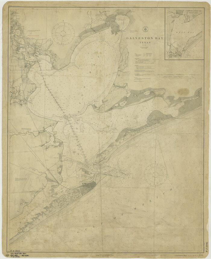
Print $20.00
- Digital $50.00
Galveston Bay
1921
Size 43.4 x 35.4 inches
Map/Doc 69872
[Capitol Leagues 217- 235, 238, and 239]
![90706, [Capitol Leagues 217- 235, 238, and 239], Twichell Survey Records](https://historictexasmaps.com/wmedia_w700/maps/90706-1.tif.jpg)
Print $20.00
- Digital $50.00
[Capitol Leagues 217- 235, 238, and 239]
Size 26.3 x 26.9 inches
Map/Doc 90706