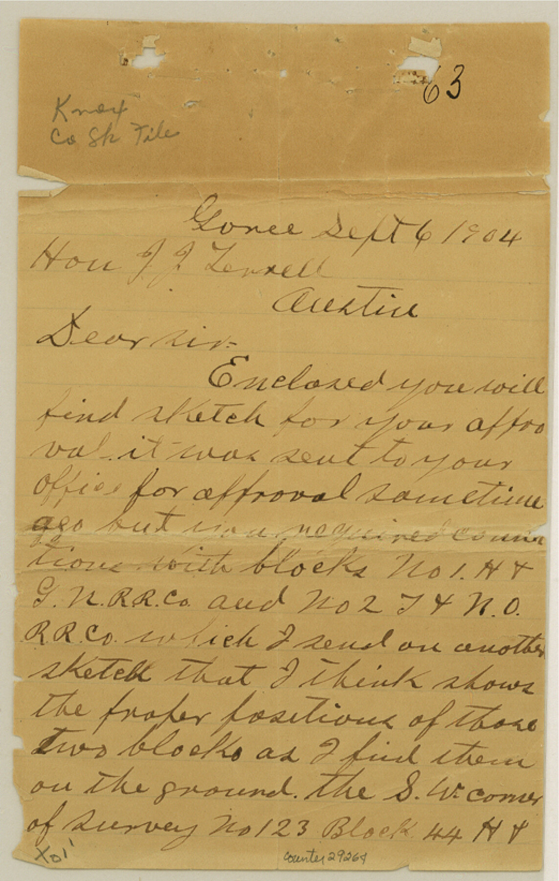
Knox County Sketch File 30
[Correspondence and sketch regarding SF-5350 and SF-5351 in northwestern part of county and into King County]
-
Map/Doc
29264
-
Collection
General Map Collection
-
Object Dates
9/6/1904 (Creation Date)
-
People and Organizations
C. Hood (Surveyor/Engineer)
E. Waldo Bedford (Surveyor/Engineer)
George L. Crum (Surveyor/Engineer)
T.A. Bedford (Surveyor/Engineer)
-
Counties
Knox
-
Subjects
Surveying Sketch File
-
Height x Width
8.2 x 5.2 inches
20.8 x 13.2 cm
-
Medium
paper, manuscript
Part of: General Map Collection
Harrison County Sketch File 9

Print $4.00
- Digital $50.00
Harrison County Sketch File 9
1862
Size 8.3 x 11.1 inches
Map/Doc 26048
El Paso County Working Sketch Graphic Index - north part

Print $20.00
- Digital $50.00
El Paso County Working Sketch Graphic Index - north part
1977
Size 33.4 x 45.0 inches
Map/Doc 76536
Newton County Sketch File 4b

Print $22.00
- Digital $50.00
Newton County Sketch File 4b
Size 7.6 x 12.2 inches
Map/Doc 32364
Ward County Working Sketch 25

Print $40.00
- Digital $50.00
Ward County Working Sketch 25
1957
Size 74.3 x 25.6 inches
Map/Doc 72331
Flight Mission No. CUG-3P, Frame 33, Kleberg County

Print $20.00
- Digital $50.00
Flight Mission No. CUG-3P, Frame 33, Kleberg County
1956
Size 18.4 x 22.2 inches
Map/Doc 86238
Flight Mission No. BRE-2P, Frame 124, Nueces County

Print $20.00
- Digital $50.00
Flight Mission No. BRE-2P, Frame 124, Nueces County
1956
Size 18.3 x 22.3 inches
Map/Doc 86800
Brazoria County Rolled Sketch 39

Print $20.00
- Digital $50.00
Brazoria County Rolled Sketch 39
1949
Size 22.8 x 34.8 inches
Map/Doc 5174
Old Miscellaneous File 34

Print $4.00
- Digital $50.00
Old Miscellaneous File 34
1881
Size 9.8 x 8.0 inches
Map/Doc 75755
Jefferson County Rolled Sketch 9

Print $20.00
- Digital $50.00
Jefferson County Rolled Sketch 9
Size 36.6 x 47.0 inches
Map/Doc 9276
Orange County Working Sketch 28

Print $20.00
- Digital $50.00
Orange County Working Sketch 28
1953
Size 26.4 x 25.2 inches
Map/Doc 71360
Kinney County Sketch File 39

Print $20.00
- Digital $50.00
Kinney County Sketch File 39
1948
Size 18.8 x 21.0 inches
Map/Doc 11951
Hopkins County Working Sketch 2

Print $20.00
- Digital $50.00
Hopkins County Working Sketch 2
1954
Size 25.3 x 21.2 inches
Map/Doc 66227
You may also like
Sabine Pass and Lake

Print $20.00
- Digital $50.00
Sabine Pass and Lake
1945
Size 46.5 x 27.3 inches
Map/Doc 69822
Hidalgo County Working Sketch 4

Print $20.00
- Digital $50.00
Hidalgo County Working Sketch 4
1938
Size 43.1 x 39.6 inches
Map/Doc 66181
Cherokee County Working Sketch 6

Print $20.00
- Digital $50.00
Cherokee County Working Sketch 6
1953
Size 40.9 x 35.1 inches
Map/Doc 67961
Stephens County Working Sketch 10

Print $40.00
- Digital $50.00
Stephens County Working Sketch 10
1921
Size 36.1 x 64.1 inches
Map/Doc 63953
Plat of surveys in El Paso Co. made for Maddox Bro's & Anderson and Gunter & Munson

Print $20.00
- Digital $50.00
Plat of surveys in El Paso Co. made for Maddox Bro's & Anderson and Gunter & Munson
Size 22.2 x 23.4 inches
Map/Doc 713
Galveston County

Print $40.00
- Digital $50.00
Galveston County
1939
Size 42.9 x 54.9 inches
Map/Doc 77287
Map showing the location of the Pecos Valley Railway through H. &. G. N. R.R. Co. Land in Reeves Co., Texas

Print $20.00
- Digital $50.00
Map showing the location of the Pecos Valley Railway through H. &. G. N. R.R. Co. Land in Reeves Co., Texas
1891
Size 37.9 x 42.6 inches
Map/Doc 64708
Presidio County Working Sketch 138

Print $20.00
- Digital $50.00
Presidio County Working Sketch 138
1990
Size 17.4 x 41.2 inches
Map/Doc 71816
Bee County Sketch File 9

Print $4.00
- Digital $50.00
Bee County Sketch File 9
Size 8.1 x 10.2 inches
Map/Doc 14289
Nacogdoches County Rolled Sketch 3

Print $20.00
- Digital $50.00
Nacogdoches County Rolled Sketch 3
1985
Size 39.6 x 27.6 inches
Map/Doc 6837
Uvalde County Working Sketch 11

Print $20.00
- Digital $50.00
Uvalde County Working Sketch 11
1943
Size 17.6 x 16.6 inches
Map/Doc 72081
Schleicher County Sketch File 3

Print $20.00
- Digital $50.00
Schleicher County Sketch File 3
Size 28.1 x 19.9 inches
Map/Doc 12295