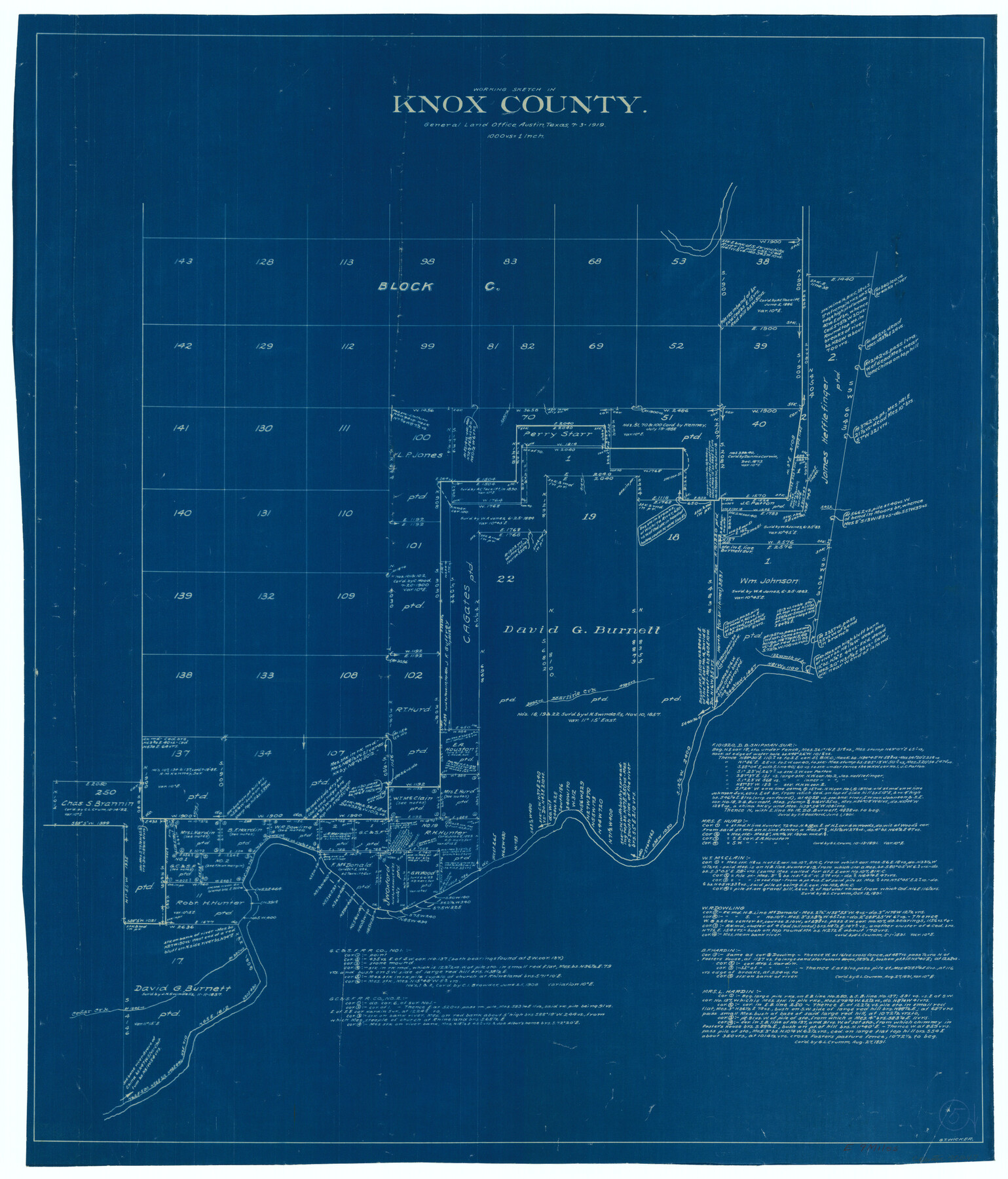
Knox County Working Sketch 5
-
Map/Doc
70247
-
Collection
General Map Collection
-
Object Dates
7/3/1919 (Creation Date)
-
People and Organizations
G.T. Wicker (Draftsman)
-
Counties
Knox
-
Subjects
Surveying Working Sketch
-
Height x Width
27.1 x 23.2 inches
68.8 x 58.9 cm
-
Scale
1" = 1000 varas
Part of: General Map Collection
Milam County Working Sketch 16

Print $20.00
- Digital $50.00
Milam County Working Sketch 16
Size 30.4 x 36.2 inches
Map/Doc 71028
Harris County Sketch File 99

Print $10.00
- Digital $50.00
Harris County Sketch File 99
1896
Size 14.5 x 8.9 inches
Map/Doc 25669
Map of the country between the frontiers of Arkansas and New Mexico embracing the section explored in 1849, 50, 51, & 52

Print $40.00
- Digital $50.00
Map of the country between the frontiers of Arkansas and New Mexico embracing the section explored in 1849, 50, 51, & 52
Size 29.9 x 62.3 inches
Map/Doc 95837
[Sketch for Mineral Application 35811 - Liberty County, John Mecom]
![65619, [Sketch for Mineral Application 35811 - Liberty County, John Mecom], General Map Collection](https://historictexasmaps.com/wmedia_w700/maps/65619.tif.jpg)
Print $4.00
- Digital $50.00
[Sketch for Mineral Application 35811 - Liberty County, John Mecom]
1941
Size 24.9 x 20.0 inches
Map/Doc 65619
Brazos River, Harlem-Imperial Farms Project

Print $4.00
- Digital $50.00
Brazos River, Harlem-Imperial Farms Project
1931
Size 29.4 x 26.6 inches
Map/Doc 65285
Gaines County

Print $20.00
- Digital $50.00
Gaines County
1956
Size 32.2 x 40.6 inches
Map/Doc 77286
Sutton County Rolled Sketch 69

Print $20.00
- Digital $50.00
Sutton County Rolled Sketch 69
Size 39.7 x 36.6 inches
Map/Doc 9981
Calhoun County Sketch File 7

Print $12.00
- Digital $50.00
Calhoun County Sketch File 7
1947
Size 14.5 x 8.9 inches
Map/Doc 35925
Bexar County Sketch File 43

Print $4.00
- Digital $50.00
Bexar County Sketch File 43
1882
Size 8.7 x 10.2 inches
Map/Doc 14522
Hamilton County Rolled Sketch 9

Print $20.00
- Digital $50.00
Hamilton County Rolled Sketch 9
1903
Size 32.8 x 30.4 inches
Map/Doc 9098
Eastland County Working Sketch 3

Print $20.00
- Digital $50.00
Eastland County Working Sketch 3
1917
Size 16.5 x 20.2 inches
Map/Doc 68784
Hudspeth County Working Sketch 10

Print $20.00
- Digital $50.00
Hudspeth County Working Sketch 10
1941
Size 16.0 x 17.1 inches
Map/Doc 66291
You may also like
Flight Mission No. CUG-3P, Frame 90, Kleberg County

Print $20.00
- Digital $50.00
Flight Mission No. CUG-3P, Frame 90, Kleberg County
1956
Size 18.6 x 22.3 inches
Map/Doc 86260
English Field Notes of the Spanish Archives - Books SAS, DB4, GWS, JWB, and JWB3

English Field Notes of the Spanish Archives - Books SAS, DB4, GWS, JWB, and JWB3
1835
Map/Doc 96551
Map of Surveys Made for the T&PRR in Andrews & Martin Counties, Blocks 37, 38, 39, 40 & 41, Reserve West of the Colorado River

Print $20.00
- Digital $50.00
Map of Surveys Made for the T&PRR in Andrews & Martin Counties, Blocks 37, 38, 39, 40 & 41, Reserve West of the Colorado River
1876
Size 42.0 x 36.8 inches
Map/Doc 2229

Stephens County Working Sketch 1

Print $20.00
- Digital $50.00
Stephens County Working Sketch 1
Size 13.5 x 16.1 inches
Map/Doc 63944
Hutchinson County Rolled Sketch 44-17

Print $20.00
- Digital $50.00
Hutchinson County Rolled Sketch 44-17
2002
Size 24.0 x 36.0 inches
Map/Doc 77553
Brazoria County Sketch File 26

Print $40.00
- Digital $50.00
Brazoria County Sketch File 26
Size 13.6 x 13.6 inches
Map/Doc 15028
Cherokee County Working Sketch 11

Print $20.00
- Digital $50.00
Cherokee County Working Sketch 11
1957
Size 24.3 x 20.2 inches
Map/Doc 67966
Map Prepared from Data by Original Field Book by W.D. Twichell

Print $40.00
- Digital $50.00
Map Prepared from Data by Original Field Book by W.D. Twichell
Size 64.0 x 40.0 inches
Map/Doc 89733
Flight Mission No. CUG-3P, Frame 30, Kleberg County

Print $20.00
- Digital $50.00
Flight Mission No. CUG-3P, Frame 30, Kleberg County
1956
Size 18.5 x 22.2 inches
Map/Doc 86235
Baylor County Sketch File 22

Print $10.00
- Digital $50.00
Baylor County Sketch File 22
1913
Size 11.2 x 8.8 inches
Map/Doc 14199
Upton County Rolled Sketch 21

Print $20.00
- Digital $50.00
Upton County Rolled Sketch 21
1939
Size 21.5 x 37.9 inches
Map/Doc 8072