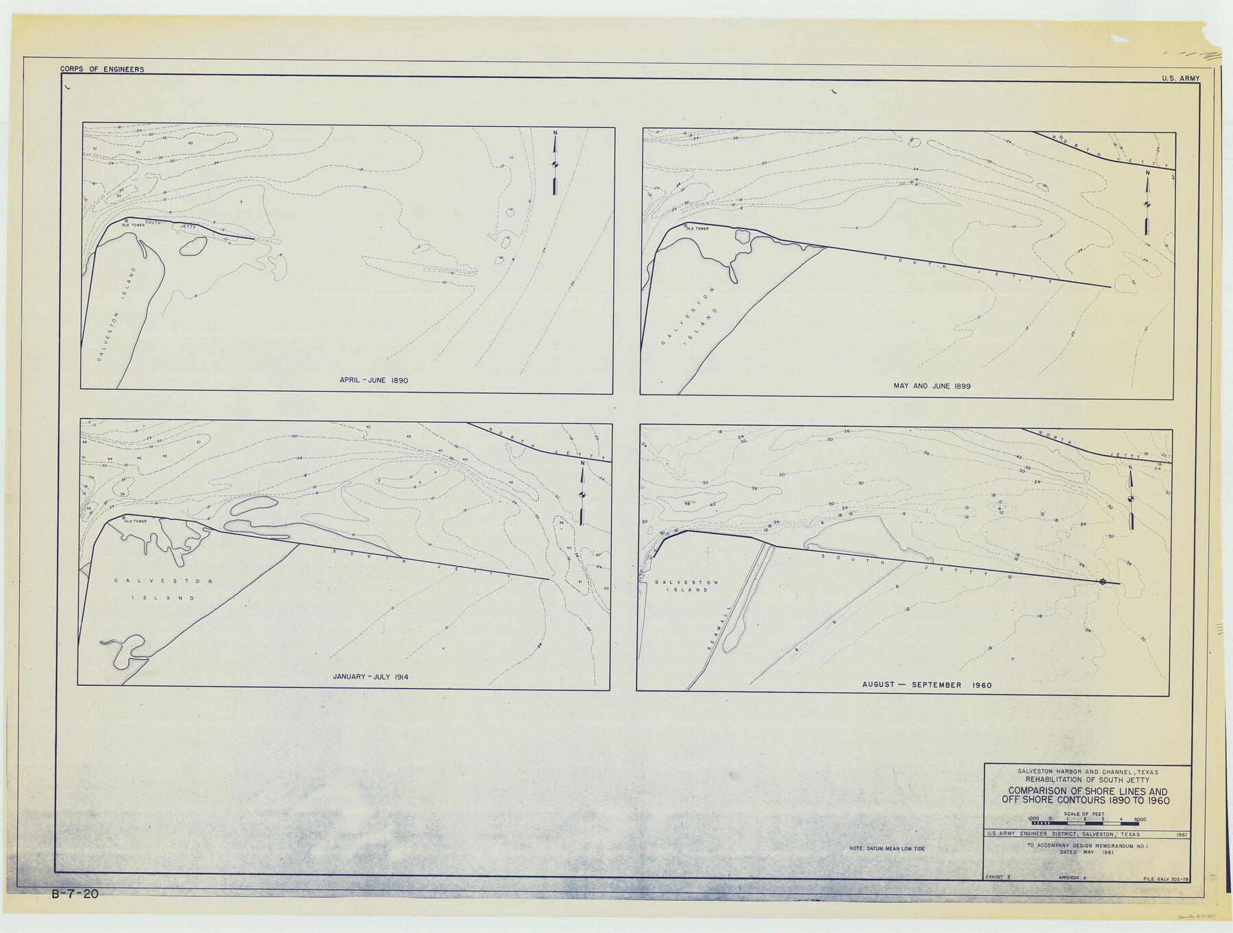
Galveston Harbor and Channel, Texas Rehabilitation of South Jetty, Comparison of Shorelines and Offshore Contours 1890 to 1960
B-7-20
- 
                          Map/Doc
61827
 - 
                            Collection
General Map Collection
 - 
                            Object Dates
1961 (Creation Date)
 - 
                            Subjects
Nautical Charts Topographic
 - 
                            Height x Width
31.6 x 41.8 inches
80.3 x 106.2 cm
 
Part of: General Map Collection
            Johnson County Working Sketch 16


                                            Print $20.00                    
                                             -                         Digital $50.00                                    
                Johnson County Working Sketch 16
1981
Size 37.3 x 38.0 inches
                                Map/Doc 66629
            
            Kimble County Working Sketch 7


                                            Print $20.00                    
                                             -                         Digital $50.00                                    
                Kimble County Working Sketch 7
1917
Size 12.6 x 16.8 inches
                                Map/Doc 70075
            
            Reeves County Rolled Sketch 17


                                            Print $20.00                    
                                             -                         Digital $50.00                                    
                Reeves County Rolled Sketch 17
1963
Size 28.4 x 36.1 inches
                                Map/Doc 7486
            
            Hays County Sketch File 31


                                            Print $6.00                    
                                             -                         Digital $50.00                                    
                Hays County Sketch File 31
1943
Size 14.4 x 8.8 inches
                                Map/Doc 26261
            
            Henderson County Sketch File 24


                                            Print $20.00                    
                                             -                         Digital $50.00                                    
                Henderson County Sketch File 24
1974
Size 27.4 x 24.1 inches
                                Map/Doc 11759
            
            Navarro County


                                            Print $40.00                    
                                             -                         Digital $50.00                                    
                Navarro County
1924
Size 41.5 x 47.9 inches
                                Map/Doc 73249
            
            Freestone County Sketch File 27


                                            Print $2.00                    
                                             -                         Digital $50.00                                    
                Freestone County Sketch File 27
1934
Size 11.3 x 8.6 inches
                                Map/Doc 23098
            
            Nueces River, Corpus Christi Sheet No. 5


                                            Print $6.00                    
                                             -                         Digital $50.00                                    
                Nueces River, Corpus Christi Sheet No. 5
1938
Size 28.4 x 33.7 inches
                                Map/Doc 65094
            
            (A No. 2) Preliminary Sketch Showing the positions of Davis's South Shoal and other Dangers recently discovered by the Coast Survey and the soundings on the Old South Shoal, Bass Rip, Old Man, Pochick Rip &c.


                                            Print $20.00                    
                                             -                         Digital $50.00                                    
                (A No. 2) Preliminary Sketch Showing the positions of Davis's South Shoal and other Dangers recently discovered by the Coast Survey and the soundings on the Old South Shoal, Bass Rip, Old Man, Pochick Rip &c.
1846
Size 19.7 x 21.8 inches
                                Map/Doc 97203
            
            Hunt County Boundary File 11


                                            Print $14.00                    
                                             -                         Digital $50.00                                    
                Hunt County Boundary File 11
Size 11.3 x 8.9 inches
                                Map/Doc 55266
            
            Map of Louisiana from D'Anville's Atlas


                                            Print $20.00                    
                                             -                         Digital $50.00                                    
                Map of Louisiana from D'Anville's Atlas
1788
Size 16.7 x 21.6 inches
                                Map/Doc 94111
            You may also like
            United States, 1956 Revised Edition


                                            Print $40.00                    
                                             -                         Digital $50.00                                    
                United States, 1956 Revised Edition
1946
Size 48.0 x 36.3 inches
                                Map/Doc 78631
            
            Upton County Rolled Sketch 59A


                                            Print $20.00                    
                                             -                         Digital $50.00                                    
                Upton County Rolled Sketch 59A
Size 35.5 x 46.3 inches
                                Map/Doc 76424
            
            Terrell County Sketch File 18


                                            Print $8.00                    
                                             -                         Digital $50.00                                    
                Terrell County Sketch File 18
1908
Size 9.1 x 4.4 inches
                                Map/Doc 37941
            
            Kimble County Working Sketch 96


                                            Print $20.00                    
                                             -                         Digital $50.00                                    
                Kimble County Working Sketch 96
1921
Size 20.9 x 26.8 inches
                                Map/Doc 70164
            
            Pecos County Boundary File 1b


                                            Print $8.00                    
                                             -                         Digital $50.00                                    
                Pecos County Boundary File 1b
Size 14.2 x 8.5 inches
                                Map/Doc 57861
            
            Red River County Working Sketch 42


                                            Print $20.00                    
                                             -                         Digital $50.00                                    
                Red River County Working Sketch 42
1968
Size 28.7 x 36.8 inches
                                Map/Doc 72025
            
            Wilbarger County Sketch File 20


                                            Print $4.00                    
                                             -                         Digital $50.00                                    
                Wilbarger County Sketch File 20
1885
Size 12.7 x 8.2 inches
                                Map/Doc 40217
            
            Live Oak County Rolled Sketch 4


                                            Print $20.00                    
                                             -                         Digital $50.00                                    
                Live Oak County Rolled Sketch 4
1946
Size 27.7 x 32.1 inches
                                Map/Doc 6633
            
            Kleberg County Boundary File 2b


                                            Print $20.00                    
                                             -                         Digital $50.00                                    
                Kleberg County Boundary File 2b
Size 8.0 x 28.9 inches
                                Map/Doc 64978
            
            Morris County Rolled Sketch 2A


                                            Print $20.00                    
                                             -                         Digital $50.00                                    
                Morris County Rolled Sketch 2A
Size 24.3 x 18.7 inches
                                Map/Doc 10675
            
            Atascosa County Sketch File 32


                                            Print $40.00                    
                                             -                         Digital $50.00                                    
                Atascosa County Sketch File 32
Size 17.6 x 19.6 inches
                                Map/Doc 10864
            
            Colorado River, Wharton to Bay City Sheet 1, Texas


                                            Print $40.00                    
                                             -                         Digital $50.00                                    
                Colorado River, Wharton to Bay City Sheet 1, Texas
1924
Size 73.9 x 38.9 inches
                                Map/Doc 65262