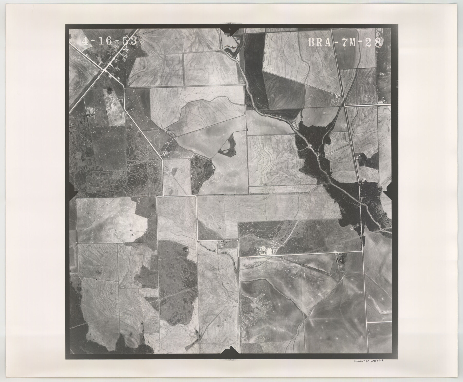
Flight Mission No. BRA-7M, Frame 28, Jefferson County
BRA-7M-28
-
Map/Doc
85479
-
Collection
General Map Collection
-
Object Dates
1953/4/16 (Creation Date)
-
People and Organizations
U. S. Department of Agriculture (Publisher)
-
Counties
Jefferson
-
Subjects
Aerial Photograph
-
Height x Width
18.5 x 22.4 inches
47.0 x 56.9 cm
-
Comments
Flown by Jack Ammann Photogrammetric Engineers of San Antonio, Texas.
Part of: General Map Collection
[Sketch for Mineral Application 13440]
![65673, [Sketch for Mineral Application 13440], General Map Collection](https://historictexasmaps.com/wmedia_w700/maps/65673-1.tif.jpg)
Print $40.00
- Digital $50.00
[Sketch for Mineral Application 13440]
Size 42.4 x 66.0 inches
Map/Doc 65673
Travis County Sketch File 12a

Print $5.00
- Digital $50.00
Travis County Sketch File 12a
1859
Size 7.9 x 9.1 inches
Map/Doc 38308
Jim Hogg County Rolled Sketch EJF

Print $20.00
- Digital $50.00
Jim Hogg County Rolled Sketch EJF
1937
Size 36.0 x 32.4 inches
Map/Doc 9320
Bosque County Sketch File 19

Print $4.00
- Digital $50.00
Bosque County Sketch File 19
1863
Size 12.9 x 6.2 inches
Map/Doc 14794
Gregg County Working Sketch Graphic Index

Print $20.00
- Digital $50.00
Gregg County Working Sketch Graphic Index
1933
Size 32.4 x 29.5 inches
Map/Doc 76559
Flight Mission No. DAG-14K, Frame 143, Matagorda County

Print $20.00
- Digital $50.00
Flight Mission No. DAG-14K, Frame 143, Matagorda County
1952
Size 16.4 x 16.4 inches
Map/Doc 86310

Padre Island National Seashore

Print $4.00
- Digital $50.00
Padre Island National Seashore
Size 16.2 x 22.2 inches
Map/Doc 60533
Rockwall County Sketch File 6

Print $4.00
- Digital $50.00
Rockwall County Sketch File 6
1862
Size 8.5 x 9.4 inches
Map/Doc 35425
McLennan County Sketch File 6

Print $4.00
- Digital $50.00
McLennan County Sketch File 6
1850
Size 7.2 x 7.9 inches
Map/Doc 31244
Real County Working Sketch 8

Print $20.00
- Digital $50.00
Real County Working Sketch 8
1928
Size 38.1 x 44.3 inches
Map/Doc 71900
Runnels County Working Sketch 25

Print $20.00
- Digital $50.00
Runnels County Working Sketch 25
1955
Size 38.2 x 47.1 inches
Map/Doc 63621
You may also like
Current Miscellaneous File 42

Print $4.00
- Digital $50.00
Current Miscellaneous File 42
Size 11.2 x 8.7 inches
Map/Doc 73981
Collin County Working Sketch Graphic Index

Print $20.00
- Digital $50.00
Collin County Working Sketch Graphic Index
1975
Size 41.4 x 39.0 inches
Map/Doc 76498
Bastrop County Rolled Sketch 6

Print $20.00
- Digital $50.00
Bastrop County Rolled Sketch 6
2013
Size 42.3 x 32.1 inches
Map/Doc 93716
The Rand-McNally New Commercial Atlas Map of Texas

The Rand-McNally New Commercial Atlas Map of Texas
1914
Size 29.4 x 40.7 inches
Map/Doc 88745
Gulf of Mexico

Print $20.00
- Digital $50.00
Gulf of Mexico
1900
Size 18.3 x 28.1 inches
Map/Doc 72650
Calhoun County Rolled Sketch 14

Print $20.00
- Digital $50.00
Calhoun County Rolled Sketch 14
Size 22.2 x 40.6 inches
Map/Doc 5369
Martin County Rolled Sketch 9

Print $20.00
- Digital $50.00
Martin County Rolled Sketch 9
1990
Size 17.3 x 11.4 inches
Map/Doc 6669
[Galveston, Harrisburg & San Antonio through El Paso County]
![64010, [Galveston, Harrisburg & San Antonio through El Paso County], General Map Collection](https://historictexasmaps.com/wmedia_w700/maps/64010.tif.jpg)
Print $20.00
- Digital $50.00
[Galveston, Harrisburg & San Antonio through El Paso County]
1906
Size 13.4 x 33.9 inches
Map/Doc 64010
Map of the City of Barry, John McGowan & J.B. & A. Adams Surveys, Navarro County, Texas

Print $20.00
- Digital $50.00
Map of the City of Barry, John McGowan & J.B. & A. Adams Surveys, Navarro County, Texas
1958
Size 28.4 x 25.4 inches
Map/Doc 94015
Reagan County Rolled Sketch 11

Print $20.00
- Digital $50.00
Reagan County Rolled Sketch 11
1931
Size 20.2 x 39.3 inches
Map/Doc 7439
Coke County Rolled Sketch 1

Print $20.00
- Digital $50.00
Coke County Rolled Sketch 1
1943
Size 26.9 x 21.6 inches
Map/Doc 5503
Flight Mission No. DQN-1K, Frame 139, Calhoun County

Print $20.00
- Digital $50.00
Flight Mission No. DQN-1K, Frame 139, Calhoun County
1953
Size 18.4 x 22.3 inches
Map/Doc 84202