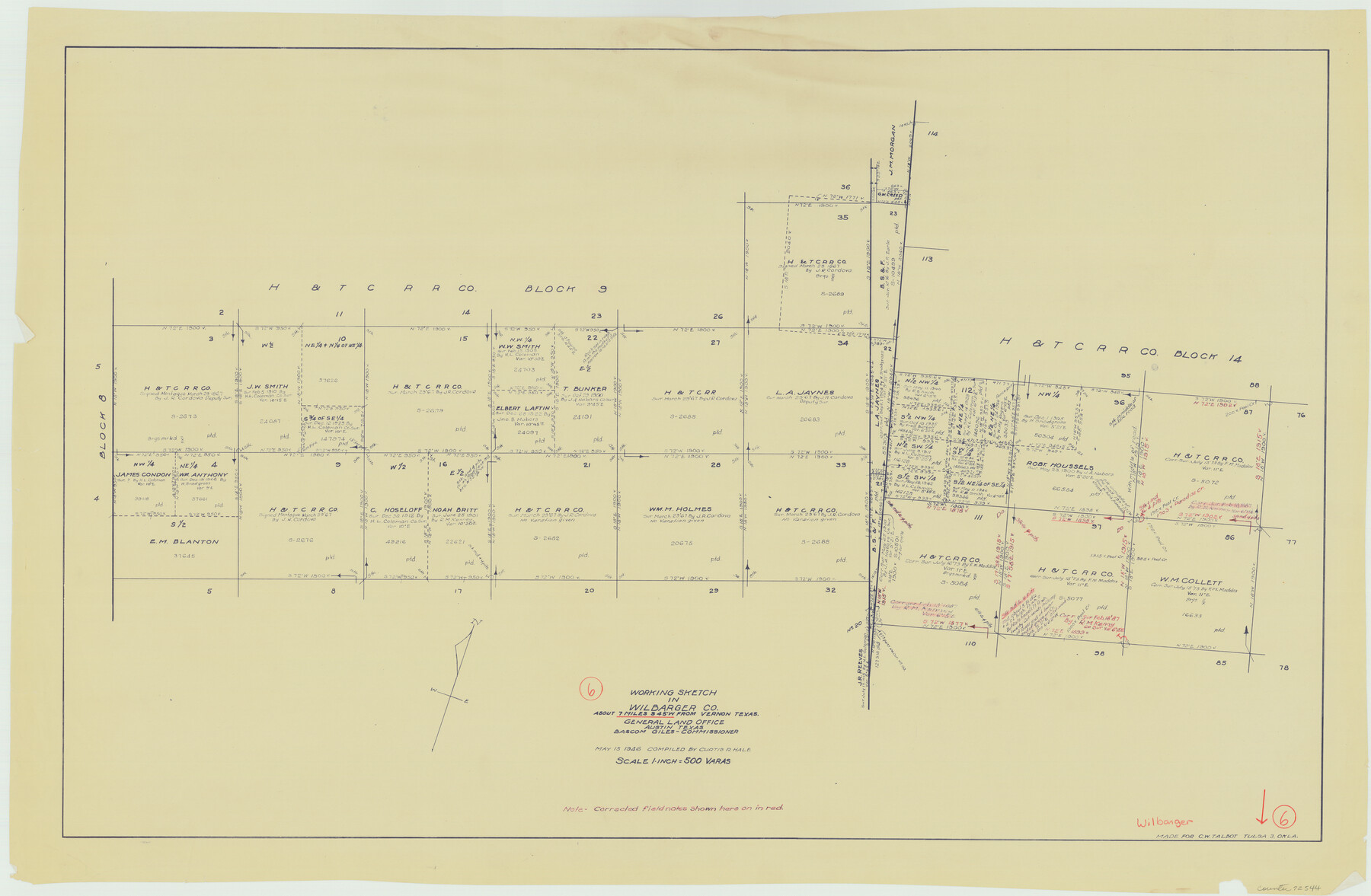
Wilbarger County Working Sketch 6
-
Map/Doc
72544
-
Collection
General Map Collection
-
Object Dates
5/15/1946 (Creation Date)
-
People and Organizations
Curtis R. Hale (Draftsman)
-
Counties
Wilbarger
-
Subjects
Surveying Working Sketch
-
Height x Width
27.1 x 41.4 inches
68.8 x 105.2 cm
-
Scale
1" = 500 varas
Part of: General Map Collection
Nueces County Rolled Sketch 3
Print $20.00
- Digital $50.00
Nueces County Rolled Sketch 3
1907
Size 17.3 x 34.2 inches
Map/Doc 6866
Hutchinson County Rolled Sketch 42

Print $40.00
- Digital $50.00
Hutchinson County Rolled Sketch 42
Size 38.0 x 49.5 inches
Map/Doc 6307
Live Oak County Working Sketch 34

Print $20.00
- Digital $50.00
Live Oak County Working Sketch 34
Size 31.0 x 42.6 inches
Map/Doc 78469
Flight Mission No. BRA-8M, Frame 118, Jefferson County

Print $20.00
- Digital $50.00
Flight Mission No. BRA-8M, Frame 118, Jefferson County
1953
Size 18.6 x 22.3 inches
Map/Doc 85614
Orange County Rolled Sketch CR

Print $20.00
- Digital $50.00
Orange County Rolled Sketch CR
Size 39.4 x 31.5 inches
Map/Doc 9653
Flight Mission No. CUG-1P, Frame 45, Kleberg County

Print $20.00
- Digital $50.00
Flight Mission No. CUG-1P, Frame 45, Kleberg County
1956
Size 18.5 x 22.2 inches
Map/Doc 86123
Starr County Boundary File 44a

Print $57.00
- Digital $50.00
Starr County Boundary File 44a
Size 9.3 x 9.4 inches
Map/Doc 58827
Webb County Sketch File 15

Print $4.00
- Digital $50.00
Webb County Sketch File 15
1878
Size 5.0 x 8.9 inches
Map/Doc 39820
Aransas County Rolled Sketch 27C

Print $20.00
- Digital $50.00
Aransas County Rolled Sketch 27C
1979
Size 17.3 x 19.3 inches
Map/Doc 5056
[Beaumont, Sour Lake and Western Ry. Right of Way and Alignment - Frisco]
![64129, [Beaumont, Sour Lake and Western Ry. Right of Way and Alignment - Frisco], General Map Collection](https://historictexasmaps.com/wmedia_w700/maps/64129.tif.jpg)
Print $20.00
- Digital $50.00
[Beaumont, Sour Lake and Western Ry. Right of Way and Alignment - Frisco]
1910
Size 20.1 x 45.9 inches
Map/Doc 64129
Newton County Sketch File 38

Print $6.00
- Digital $50.00
Newton County Sketch File 38
Size 16.1 x 11.0 inches
Map/Doc 32417
Gonzales County

Print $40.00
- Digital $50.00
Gonzales County
1986
Size 41.6 x 54.7 inches
Map/Doc 73160
You may also like
Rebel Defenses of Galveston and Vicinity

Print $20.00
- Digital $50.00
Rebel Defenses of Galveston and Vicinity
1865
Size 17.0 x 23.7 inches
Map/Doc 61802
Dimmit County Working Sketch 18

Print $20.00
- Digital $50.00
Dimmit County Working Sketch 18
1946
Size 33.5 x 35.0 inches
Map/Doc 68679
Lamar County Sketch File 3

Print $6.00
- Digital $50.00
Lamar County Sketch File 3
1864
Size 14.2 x 8.6 inches
Map/Doc 29275
Flight Mission No. DAG-21K, Frame 37, Matagorda County

Print $20.00
- Digital $50.00
Flight Mission No. DAG-21K, Frame 37, Matagorda County
1952
Size 18.5 x 22.4 inches
Map/Doc 86404
Pecos County Working Sketch 10

Print $20.00
- Digital $50.00
Pecos County Working Sketch 10
1907
Size 25.9 x 23.9 inches
Map/Doc 71480
Nueces County Sketch File 13a

Print $12.00
- Digital $50.00
Nueces County Sketch File 13a
1889
Size 13.8 x 9.0 inches
Map/Doc 32539
Bowie County Rolled Sketch 6A

Print $20.00
- Digital $50.00
Bowie County Rolled Sketch 6A
1992
Size 11.3 x 17.8 inches
Map/Doc 5162
Denton County Working Sketch 36

Print $20.00
- Digital $50.00
Denton County Working Sketch 36
2008
Size 18.5 x 29.0 inches
Map/Doc 88877
San Patricio County Rolled Sketch 47A

Print $20.00
- Digital $50.00
San Patricio County Rolled Sketch 47A
1939
Size 27.7 x 28.5 inches
Map/Doc 7732
Clay County Boundary File 16

Print $56.00
- Digital $50.00
Clay County Boundary File 16
Size 9.1 x 3.7 inches
Map/Doc 51422
Galveston County Working Sketch 5

Print $20.00
- Digital $50.00
Galveston County Working Sketch 5
1934
Size 41.2 x 41.0 inches
Map/Doc 69342
McMullen County Sketch File 13

Print $4.00
- Digital $50.00
McMullen County Sketch File 13
1876
Size 10.0 x 8.0 inches
Map/Doc 31359