Travis County State Real Property Sketch 4
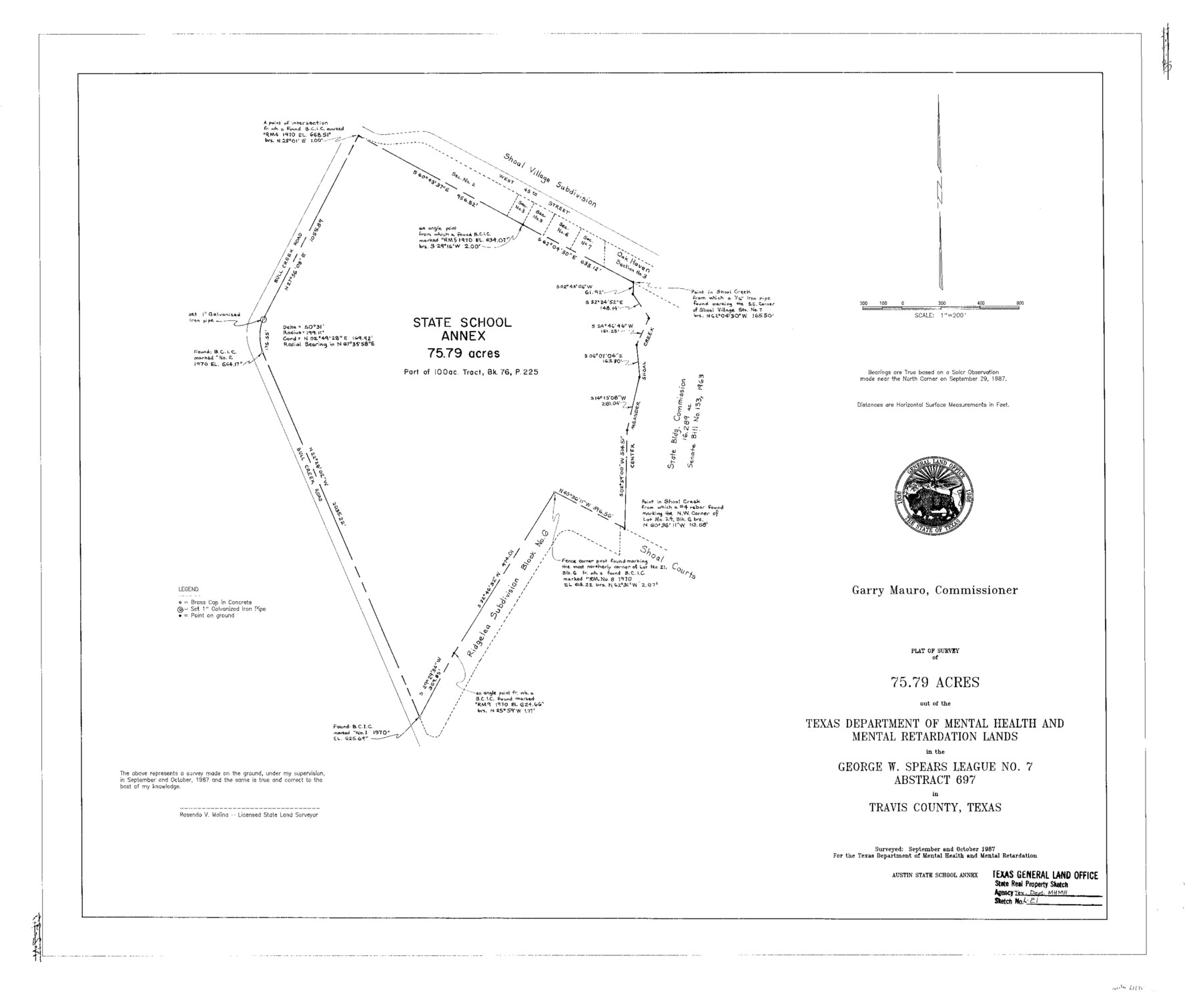
A Plat of a Survey of 75.79 Acres Out of the Texas Department of Mental Health and Mental Retardation Lands, Austin State School Annex, in the George W. Spears League 7, A - 697
S- R- P. Sketch L - 21; N.2.90; N.2.92
-
Map/Doc
61695
-
Collection
General Map Collection
-
Object Dates
1987 (Creation Date)
-
People and Organizations
Texas General Land Office (Publisher)
Texas General Land Office (Printer)
Garry Mauro (GLO Commissioner)
Rosendo V. Molina (Surveyor/Engineer)
-
Counties
Travis
-
Subjects
State Real Property
-
Height x Width
25.7 x 30.7 inches
65.3 x 78.0 cm
-
Comments
Surveyed September and October 1987.
Surveys located about two and one half miles North 75 degrees West of Austin, Texas.
One or more items in this file were formerly filed in another file. They have been reunited in this file with their original g
Part of: General Map Collection
Map of the Mississippi River from its Source to the Mouth of the Missouri

Print $20.00
- Digital $50.00
Map of the Mississippi River from its Source to the Mouth of the Missouri
1810
Size 10.4 x 31.3 inches
Map/Doc 95153
Medina County Working Sketch 9

Print $20.00
- Digital $50.00
Medina County Working Sketch 9
1959
Size 25.3 x 38.8 inches
Map/Doc 70924
Pecos County Rolled Sketch 171

Print $20.00
- Digital $50.00
Pecos County Rolled Sketch 171
1975
Size 17.3 x 17.0 inches
Map/Doc 7293
1910 Map of the City of Houston and vicinity

Print $20.00
- Digital $50.00
1910 Map of the City of Houston and vicinity
1910
Size 20.5 x 23.4 inches
Map/Doc 97452
Flight Mission No. CUG-1P, Frame 112, Kleberg County

Print $20.00
- Digital $50.00
Flight Mission No. CUG-1P, Frame 112, Kleberg County
1956
Size 18.5 x 22.3 inches
Map/Doc 86162
Erath County Sketch File 10

Print $4.00
- Digital $50.00
Erath County Sketch File 10
1871
Size 8.1 x 10.3 inches
Map/Doc 22275
Flight Mission No. BRA-8M, Frame 75, Jefferson County

Print $20.00
- Digital $50.00
Flight Mission No. BRA-8M, Frame 75, Jefferson County
1953
Size 18.6 x 22.4 inches
Map/Doc 85595
Rusk County Rolled Sketch 15

Print $40.00
- Digital $50.00
Rusk County Rolled Sketch 15
2000
Size 62.4 x 21.2 inches
Map/Doc 10636
Tom Green County Working Sketch 8

Print $20.00
- Digital $50.00
Tom Green County Working Sketch 8
1950
Size 24.8 x 20.9 inches
Map/Doc 69377
[Galveston, Harrisburg & San Antonio through El Paso County]
![64005, [Galveston, Harrisburg & San Antonio through El Paso County], General Map Collection](https://historictexasmaps.com/wmedia_w700/maps/64005.tif.jpg)
Print $20.00
- Digital $50.00
[Galveston, Harrisburg & San Antonio through El Paso County]
1906
Size 13.3 x 33.6 inches
Map/Doc 64005
Flight Mission No. DCL-6C, Frame 14, Kenedy County

Print $20.00
- Digital $50.00
Flight Mission No. DCL-6C, Frame 14, Kenedy County
1943
Size 18.7 x 22.4 inches
Map/Doc 85871
Flight Mission No. DAG-19K, Frame 60, Matagorda County

Print $20.00
- Digital $50.00
Flight Mission No. DAG-19K, Frame 60, Matagorda County
1952
Size 18.6 x 22.2 inches
Map/Doc 86387
You may also like
Cottle County Working Sketch 7

Print $20.00
- Digital $50.00
Cottle County Working Sketch 7
1916
Size 28.4 x 30.4 inches
Map/Doc 68317
Flight Mission No. DCL-6C, Frame 71, Kenedy County

Print $20.00
- Digital $50.00
Flight Mission No. DCL-6C, Frame 71, Kenedy County
1943
Size 18.6 x 22.3 inches
Map/Doc 85913
Chambers County Sketch File 44

Print $36.00
- Digital $50.00
Chambers County Sketch File 44
Size 13.9 x 8.7 inches
Map/Doc 17735
Tarrant County Sketch File 19

Print $4.00
- Digital $50.00
Tarrant County Sketch File 19
Size 9.7 x 8.1 inches
Map/Doc 37721
S. Part of Gomez

Print $20.00
- Digital $50.00
S. Part of Gomez
Size 23.5 x 19.6 inches
Map/Doc 92295

Webb County Sketch File LM3

Print $20.00
- Digital $50.00
Webb County Sketch File LM3
1924
Size 24.7 x 31.9 inches
Map/Doc 12658
Dallas County Boundary File 6g

Print $6.00
- Digital $50.00
Dallas County Boundary File 6g
Size 11.2 x 8.7 inches
Map/Doc 52275
Plan C, Part 1st Shewing that portion of the boundary between Texas and the United States, included between the intersection of the 32nd degree of Latitude with western bank of Sabine River and the 36th mile mound

Print $20.00
- Digital $50.00
Plan C, Part 1st Shewing that portion of the boundary between Texas and the United States, included between the intersection of the 32nd degree of Latitude with western bank of Sabine River and the 36th mile mound
1842
Size 19.4 x 27.7 inches
Map/Doc 65412
Brooks County Rolled Sketch 7

Print $20.00
- Digital $50.00
Brooks County Rolled Sketch 7
1916
Size 28.5 x 30.4 inches
Map/Doc 5336
Grayson County Sketch File 6

Print $8.00
- Digital $50.00
Grayson County Sketch File 6
Size 12.9 x 8.2 inches
Map/Doc 24466
Hemphill County, State of Texas

Print $20.00
- Digital $50.00
Hemphill County, State of Texas
1888
Size 22.0 x 17.4 inches
Map/Doc 6187