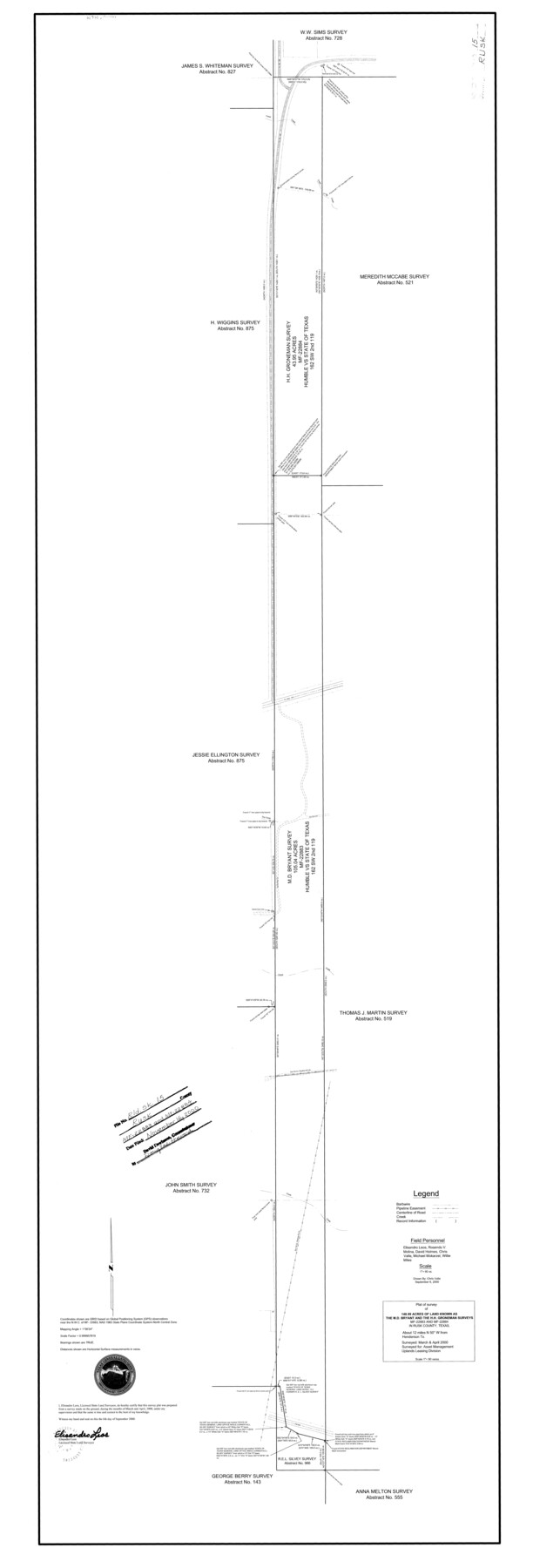
Rusk County Rolled Sketch 15
Plat of survey of 148.99 acres of land known as the M.D. Bryant and the H.H. Groneman surveys MF-22883 and MF-22884 in Rusk County, Texas
-
Map/Doc
10636
-
Collection
General Map Collection
-
Object Dates
2000 (Survey Date)
2000/11/16 (File Date)
2000/9/6 (Creation Date)
-
People and Organizations
Chris Valle (Draftsman)
Elisandro Leos (Surveyor/Engineer)
-
Counties
Rusk
-
Subjects
Surveying Rolled Sketch
-
Height x Width
62.4 x 21.2 inches
158.5 x 53.8 cm
-
Medium
mylar, print
-
Scale
1" = 90 varas
Part of: General Map Collection
Travis County Rolled Sketch 36

Print $20.00
- Digital $50.00
Travis County Rolled Sketch 36
Size 33.9 x 24.5 inches
Map/Doc 8037
Williamson County Sketch File 1

Print $4.00
- Digital $50.00
Williamson County Sketch File 1
1847
Size 8.8 x 10.1 inches
Map/Doc 40299
Wharton County Sketch File A3

Print $26.00
- Digital $50.00
Wharton County Sketch File A3
1899
Size 18.2 x 18.6 inches
Map/Doc 12671
Jackson County Working Sketch 10

Print $20.00
- Digital $50.00
Jackson County Working Sketch 10
1991
Size 35.9 x 36.1 inches
Map/Doc 66458
San Patricio County Rolled Sketch 42

Print $20.00
- Digital $50.00
San Patricio County Rolled Sketch 42
Size 18.6 x 37.3 inches
Map/Doc 7728
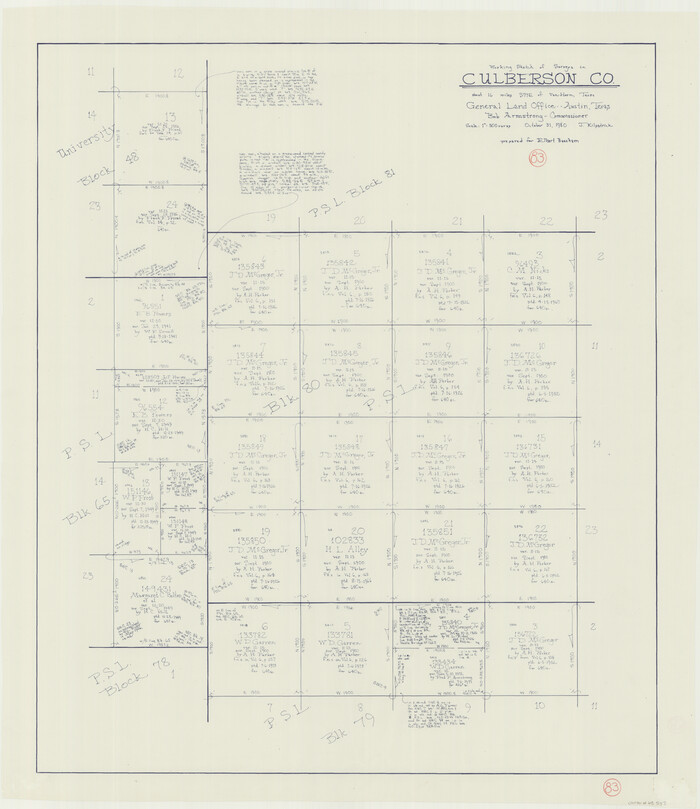
Culberson County Working Sketch 83
Print $20.00
- Digital $50.00
Culberson County Working Sketch 83
1980
Size 33.4 x 28.9 inches
Map/Doc 68537
Montgomery County Working Sketch 8b

Print $20.00
- Digital $50.00
Montgomery County Working Sketch 8b
1932
Size 17.7 x 20.7 inches
Map/Doc 71115
Concho County Working Sketch Graphic Index

Print $20.00
- Digital $50.00
Concho County Working Sketch Graphic Index
1947
Size 45.8 x 35.6 inches
Map/Doc 76503
Map of the County of Nueces

Print $20.00
- Digital $50.00
Map of the County of Nueces
1859
Size 39.3 x 39.6 inches
Map/Doc 78391
Map of Nacogdoches County

Print $20.00
- Digital $50.00
Map of Nacogdoches County
1881
Size 23.7 x 21.0 inches
Map/Doc 4599
Oldham County Working Sketch 1

Print $20.00
- Digital $50.00
Oldham County Working Sketch 1
1901
Size 40.2 x 24.7 inches
Map/Doc 71323
Upton County Working Sketch 17

Print $20.00
- Digital $50.00
Upton County Working Sketch 17
1941
Size 36.1 x 22.1 inches
Map/Doc 69513
You may also like
Wichita County Working Sketch 3

Print $20.00
- Digital $50.00
Wichita County Working Sketch 3
1913
Size 22.2 x 15.6 inches
Map/Doc 72512

[Map of Counties south of Panhandle]
![92960, [Map of Counties south of Panhandle], Twichell Survey Records](https://historictexasmaps.com/wmedia_w700/maps/92960-1.tif.jpg)
Print $20.00
- Digital $50.00
[Map of Counties south of Panhandle]
Size 22.1 x 15.8 inches
Map/Doc 92960
Lamb County Sketch File 10

Print $22.00
- Digital $50.00
Lamb County Sketch File 10
1912
Size 20.0 x 31.2 inches
Map/Doc 11972
Rusk County Sketch File 39

Print $6.00
Rusk County Sketch File 39
1951
Size 11.3 x 8.9 inches
Map/Doc 35579
Kent County Sketch File 1

Print $6.00
- Digital $50.00
Kent County Sketch File 1
1882
Size 10.9 x 12.2 inches
Map/Doc 28823
Hardin County Sketch File 64

Print $24.00
- Digital $50.00
Hardin County Sketch File 64
1936
Size 24.5 x 25.6 inches
Map/Doc 11638
Maps of Gulf Intracoastal Waterway, Texas - Sabine River to the Rio Grande and connecting waterways including ship channels

Print $20.00
- Digital $50.00
Maps of Gulf Intracoastal Waterway, Texas - Sabine River to the Rio Grande and connecting waterways including ship channels
1966
Size 14.6 x 22.2 inches
Map/Doc 61947
Crosby County Boundary File 5

Print $60.00
- Digital $50.00
Crosby County Boundary File 5
Size 14.3 x 8.8 inches
Map/Doc 52033
Knox County Boundary File 104

Print $10.00
- Digital $50.00
Knox County Boundary File 104
Size 9.2 x 7.4 inches
Map/Doc 65051
Houston Ship Channel, Alexander Island to Carpenter Bayou

Print $40.00
- Digital $50.00
Houston Ship Channel, Alexander Island to Carpenter Bayou
1982
Size 35.7 x 49.4 inches
Map/Doc 69914
San Saba County Working Sketch 8

Print $20.00
- Digital $50.00
San Saba County Working Sketch 8
1979
Size 13.3 x 17.2 inches
Map/Doc 63796